Voyage details and related metadata, reports, events and data.
IN2021_E04
- is a Marine National Facility ![]() voyage
voyage
Title: Calibration, Science trials - Kongsberg and seismic commissioning and trials
Voyage details on MNF site: https://mnf.csiro.au/en/Voyages/IN2021_E04
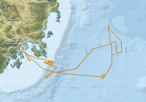
Period: 2021-12-14 21:00 to 2021-12-19 21:00 UTC
Duration: 5.00 days
From: Hobart To: Hobart
Region: Derwent estuary; Tasmania coast southeast; Southern Ocean
Ship: Investigator (RV) [details]
Description: Equipment testing
Project: Investigator - general vessel operations, gear trials, etc. [details] Primary
Underway data from NRUD - see this voyage
Voyage extents: 43° 46.0' S to 42° 26.0' S 147° 20.4' E to 149° 53.3' E Get voyage track shapefile Get CSV
Marlin Metadata:-
Cruise Summary Report at SeaDataNet:-
Participants - on ship:-
| Name | Role | Organisation |
|---|---|---|
| Tara Martin | Chief Scientist | CSIRO National Collections and Marine Infrastructure |
This list includes those that may have only been on part of the voyage. See voyage reports on 'Reports and Maps' tab for details.
Marine National Facility Reports - plans, summaries and data processing
-
IN2021_E04 ADCP Data Processing Report
- details of data processing steps, calibration information, instruments used and any issues with the data.
- View Survey map
Publications, reports and datasets from this voyage.
Dataset
- Martin, Tara; Berry, Chris; Davey, Craig; Boyd, Matt; Navidad, Cisco; Taylor, Charlie; Plunkett, Tom (2022): IN2021_E04 South-East Tasmania Bathymetry 5m - 210m Multi-resolution AusSeabed products. v1. CSIRO. Data Collection. 10.25919/emcn-qr26
- Tilbrook, Bronte; Neill, Craig; Akl, John (2022). Integrated Marine Observing System (IMOS) sea surface and atmospheric fCO2 measurements in the Southern Ocean, South Pacific, Indian Ocean onboard R/V Investigator in 2021 (NCEI Accession 0253535). [indicate subset used]. NOAA National Centers for Environmental Information. Dataset. 10.25921/thsr-dd03
Journal Article
- Lucieer, Vanessa,Flukes, Emma,Monk, Jacquomo,Walsh, Peter (2024) Geomorphometric maps of Australia’s Marine Park estate and their role in improving the integrated monitoring and management of marine ecosystems. Frontiers in Marine Science 10 pp-. 10.3389/fmars.2023.1302108
Search for publications, reports and datasets from this and other voyages
Data publishing
This is a list of online datasets hosted by CSIRO. Other processed datasets hosted by collaborating organisations may be found on the 'Metadata' or "Reports, Publications and Maps' tab.
Use the Get data link on the right to extract data using the NCMI Data Trawler.
| Data Stream | Data Summary | Get data | ||||||||||||||
|---|---|---|---|---|---|---|---|---|---|---|---|---|---|---|---|---|
| ADCP Data |
|
Get Data from Trawler Download the 5 minute ADCP os150nb Data (NetCDF format) Download overview plots of collected OS150nb ADCP data Download the 5 minute ADCP os75nb Data (NetCDF format) Download overview plots of collected OS75nb ADCP data |
||||||||||||||
| Gravity Measurements |
|
Get Data from Trawler |
||||||||||||||
| Multibeam echosounder |
|
Get Data from Trawler |
||||||||||||||
| pCO2 |
|
External link - download datafile at IMOS Data fields and units document (.pdf) |
||||||||||||||
| Sub-bottom profiler |
|
Get Data from Trawler |
||||||||||||||
| Singlebeam echosounder |
|
Get Data from Trawler |
| ID | When (UTC) | Lat | Long | Instrument | Identifier | Action | Log | Subject / Comment |
|---|
Deployments by start time:- Click on column header to sort. Use link on 'Deployment' to see full details. Use the CSV button at the bottom to export data (tab delimited).
Search for deployments from this voyage and others
| Deployment | Operation | Station | Cast | Gear | Project | Start and end times | Start Location | End Location | Depth range | Max Depth | Description | |||
|---|---|---|---|---|---|---|---|---|---|---|---|---|---|---|
| ADCP Data [details] | Teledyne RDI ADCP 75 kHz | 2549 | 2021-12-14 22:32 | 2021-12-19 18:20 | -43.0926 | 147.4362 | -43.0806 | 147.4263 | 750 | |||||