Voyage details and related metadata, reports, events and data.
IN2021_E03
- is a Marine National Facility ![]() voyage
voyage
Title: Equipment Trials and Calibrations 2021
Voyage details on MNF site: https://mnf.csiro.au/en/Voyages/IN2021_E03
Period: 2021-11-30 22:30 to 2021-12-07 22:10 UTC
Duration: 6.99 days
From: Hobart To: Hobart
Ship: Investigator (RV) [details]
Description:
The primary voyage objective for these voyages, are for the Marine National Facility (MNF) to calibrate and commission new, upgraded and existing critical equipment (with sea trials and personnel training) onboard RV Investigator for upcoming voyages in the 2021 schedule and beyond.
Specifically, work will focus on the seagoing testing and trials of MNF’s new Giant Piston Corer with 24m maximum barrel length capability, principally supported by the Geophysical Survey and Mapping team and marine geoscientists from UTAS.
Additionally the voyage will finalise the calibration of the CTD#2 winch with Rapp Macgregor personnel, crew and support staff.
Ancilliary Objectives (Piggybacks)
The following anciliary voyage objectives are targeted where they don’t limit or impact above priorities.
- A small contingent of scientists will advise on QAQC for collection of piston coring samples. The scientific advisors have supported voyage planning by advising appropriate sites of interest that target reduced risks to equipment and personnel, aid commissioning and gain scientific insight, notable thanks to Alix Post and Scott Nichol from Geoscience Australia. Due to traveling restrictions, Martin Jutzeler and Acacia Clark have agreed to fill in this QAQC role onboard the voyage. If cores are successful and of scientific value, they will be provided to the scientific advisors for analysis post voyage in accordance with CSIRO’s Data and Sample Management Policy.
- Underway aerosol particulate CO2 sensor upgrade & replacement, testing & monitoring underway by Craig Neill from O&A.
Project: Investigator - general vessel operations, gear trials, etc. [details] Primary
Underway data from NRUD - see this voyage
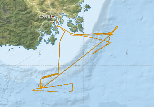
Voyage extents: 44° 37.0' S to 42° 53.2' S 146° 49.5' E to 148° 47.7' E Get voyage track shapefile Get CSV
Marlin Metadata:-
Cruise Summary Report at SeaDataNet:-
Participants - on ship:-
| Name | Role | Organisation | Project |
|---|---|---|---|
| Jason Fazey | Chief Scientist | CSIRO National Collections and Marine Infrastructure | Investigator - general vessel operations, gear trials, etc. |
This list includes those that may have only been on part of the voyage. See voyage reports on 'Reports and Maps' tab for details.
Marine National Facility Reports - plans, summaries and data processing
-
IN2021_E03 Voyage Plan
- includes objectives, investigator details, proposed data collection, voyage track and equipment to be used.
-
IN2021_E03 Voyage Summary
- includes preliminary results, voyage narrative, types of data collected with C77/ROSCOP codes.
-
IN2021_E03 ADCP Data Processing Report
- details of data processing steps, calibration information, instruments used and any issues with the data.
-
IN2021_E03 Underway Data Processing Report
- details of data processing steps, calibration information, instruments used and any issues with the data.
- View Survey map
Publications, reports and datasets from this voyage.
Dataset
- Fazey, Jason; Boyd, Matt; Berry, Chris; Kuna, Nelson; Navidad, Cisco; Taylor, Charlie; Plunkett, Tom (2022): IN2021_E03 South-East Tasmania Bathymetry 5m - 210m Multi-resolution AusSeabed products. v1. CSIRO. Data Collection. 10.25919/fzt3-a364
- Tilbrook, Bronte; Neill, Craig; Akl, John (2022). Integrated Marine Observing System (IMOS) sea surface and atmospheric fCO2 measurements in the Southern Ocean, South Pacific, Indian Ocean onboard R/V Investigator in 2021 (NCEI Accession 0253535). [indicate subset used]. NOAA National Centers for Environmental Information. Dataset. 10.25921/thsr-dd03
Journal Article
- Lucieer, Vanessa,Flukes, Emma,Monk, Jacquomo,Walsh, Peter (2024) Geomorphometric maps of Australia’s Marine Park estate and their role in improving the integrated monitoring and management of marine ecosystems. Frontiers in Marine Science 10 pp-. 10.3389/fmars.2023.1302108
Search for publications, reports and datasets from this and other voyages
Data publishing
This is a list of online datasets hosted by CSIRO. Other processed datasets hosted by collaborating organisations may be found on the 'Metadata' or "Reports, Publications and Maps' tab.
Use the Get data link on the right to extract data using the NCMI Data Trawler.
| Data Stream | Data Summary | Get data | ||||||||||||||
|---|---|---|---|---|---|---|---|---|---|---|---|---|---|---|---|---|
| ADCP Data |
|
Get Data from Trawler Download the 5 minute ADCP OS150nb Data (NetCDF format) Download overview plots of collected OS150nb ADCP data Download the 5 minute ADCP OS75nb Data (NetCDF format) Download overview plots of collected OS75nb ADCP data |
||||||||||||||
| Gravity Measurements |
|
Get Data from Trawler |
||||||||||||||
| Multibeam echosounder |
|
Get Data from Trawler |
||||||||||||||
| pCO2 |
|
External link - download datafile at IMOS Data fields and units document (.pdf) |
||||||||||||||
| Sub-bottom profiler |
|
Get Data from Trawler |
||||||||||||||
| Singlebeam echosounder |
|
Get Data from Trawler |
||||||||||||||
| Underway |
|
Get Data from Trawler Download the 5 minute Underway data (CSV format) Download the 1 minute Underway data (CSV format) Download the 5 second Underway data (netCDF format) Download the 5 second Underway data (CSV format) Download the 10-second Underway data (CSV format) |
| ID | When (UTC) | Lat | Long | Instrument | Identifier | Action | Log | Subject / Comment |
|---|
Deployments by start time:- Click on column header to sort. Use link on 'Deployment' to see full details. Use the CSV button at the bottom to export data (tab delimited).
Search for deployments from this voyage and others
| Deployment | Operation | Station | Cast | Gear | Project | Start and end times | Start Location | End Location | Depth range | Max Depth | Description | |||
|---|---|---|---|---|---|---|---|---|---|---|---|---|---|---|
| Underway System [details] | Air Sampling Inlet Mode,Air Temperature Sensor - ROTRONIC T&RH HC2A-S3,Air Temperature Sensor - ROTRONIC T&RH HC2A-S3,Air Temperature Sensor - ROTRONIC T&RH HC2A-S3,Air Temperature Sensor - ROTRONIC T&RH HC2A-S3,Burket Flow meter,Burket Flow meter,CSIRO Hobart pCO2,CSIRO Hobart pCO2,CSIRO Hobart pCO2,CSIRO Hobart pCO2,CSIRO Hobart pCO2,CSIRO Hobart pCO2,CSIRO Hobart pCO2,CSIRO Hobart pCO2,CSIRO Hobart pCO2,CSIRO Hobart pCO2,CSIRO air sampling inlet,CSIRO air sampling inlet,Depth: TECHSAS-DERIVED. For more information contact the Data Acquisition and Processing group.,Fluorometer Concentration,Fluorometer WSCHL-1441,Gyrocompass,IMOS Port Pyranometer-SN 35122F3,IMOS Port Radiometer-SN 35093F3,IMOS Stbd Pyranometer-SN 35123F3,IMOS Stbd Radiometer-SN 35111F3,IMOS wind monitor,IMOS wind monitor,IMOS wind monitor,IMOS wind monitor,ISAR SST,Kobold MIK-C Flow meter,Kobold MIK-C Fluorometer Flow Meter,Kongsberg Maritime Skipper DL850 doppler log,Kongsberg Maritime Skipper DL850 doppler log,Kongsberg Maritime Skipper DL850 doppler log,Kongsberg Maritime Skipper DL850 doppler log,Kongsberg Maritime Skipper DL850 doppler log,Kongsberg Maritime Skipper DL850 doppler log,LI-COR LI-190 Quantum Sensor,LI-COR LI-190 Quantum Sensor,MAAP Status,Multiangle Absorption Photometer (MAAP),Multiangle Absorption Photometer (MAAP),Optode Dissolved Oxygen Concentration,Optode Dissolved Oxygen Saturation,Optode Water Temperature,Ozone Monitor RVT1,Ozone Monitor RVT1,Ozone Monitor RVT2,Ozone Monitor RVT2,Picarro Greenhouse Gas Spectrometer CO2,CH4,H2o,Picarro Greenhouse Gas Spectrometer CO2,CH4,H2o,Picarro Greenhouse Gas Spectrometer CO2,CH4,H2o,Port Rain Gauge,Port drop keel sensor,RM Young 05106 wind monitor,RM Young 05106 wind monitor,RM Young Wind Sensor Type 05106,RM Young Wind Sensor Type 05106,RM Young Wind Sensor Type 05106,RM Young Wind Sensor Type 05106,RM Young Wind Sensor Type 05106,RM Young Wind Sensor Type 05106,RM Young Wind Sensor Type 05106,Remote Temperature (T) - SN 1061,Seapath 330+,Seapath 330+,Seapath 330+,Seapath 330+,Starboard Rain Gauge,Starboard drop keel sensor,ThermoSalinoGraph (TSG)-SN 3439,ThermoSalinoGraph (TSG)-SN 3439,Vaisala Ship's Barometer PTB330 | 2021-11-30 23:00 | 2021-12-07 22:00 | -42.8864 | 147.3388 | |||||||||
| ADCP Data [details] | Teledyne RDI ADCP 75 kHz | 2549 | 2021-12-01 09:08 | 2021-12-07 18:16 | -43.1609 | 147.5603 | -43.1092 | 147.4764 | 734 | |||||