Voyage details and related metadata, reports, events and data.
IN2019_T03
- is a Marine National Facility ![]() voyage
voyage
Title: Transit 03
Voyage details on MNF site: https://mnf.csiro.au/en/Voyages/IN2019_T03
Period: 2019-12-21 21:30 to 2020-01-02 05:00 UTC
Duration: 11.31 days
From: Darwin To: Fremantle
Region: Northern Terrirtory Coast; Western Australia Coast
Ship: Investigator (RV) [details]
Description: The voyage objectives are to collect Investigator C-band Doppler dual-polarization weather radar (SEAPOL), Ocean RAIN, ODM470 disdrometer, and micro rain radar (MRR-2) observations of precipitation collocated with as many radars from the BoM operational radar network located along the coast from Darwin to Fremantle.
Leader: Alain Protat (BOM)
Projects:
-
Investigator National Facility - transit voyage [details] Primary
-
ORCA: Using the Investigator radar as a moving reference for the Australian operational radar network [details] Primary
-
Microplastics in the food chain: impact on the microbial and planktonic organisms [details] Supplementary
-
Spatial and temporal variability in the distribution and abundance of seabirds and marine mammals [details] Supplementary
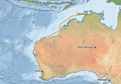
Voyage extents: 32° 12.3' S to 12° 17.3' S 112° 42.9' E to 130° 50.8' E Get voyage track shapefile Get CSV
Marlin Metadata:-
Cruise Summary Report at SeaDataNet:-
Participants - on ship:-
| Name | Role | Organisation | Project |
|---|---|---|---|
| Alain Protat | Chief Scientist | Bureau of Meteorology | ORCA: Using the Investigator radar as a moving reference for the Australian operational radar network |
| Elise Tuuri | Lead Principal investigator | Flinders University | Microplastics in the food chain: impact on the microbial and planktonic organisms |
| Eric Woehler | Lead Principal investigator | Birdlife Australia | Spatial and temporal variability in the distribution and abundance of seabirds and marine mammals |
| Matt Boyd | Voyage Manager | CSIRO National Collections and Marine Infrastructure | Voyage Management on RV Investigator |
Participants - shore based:-
| Name | Role | Organisation | Project |
|---|---|---|---|
| Robyn Schofield | PI - suppl. project | University of Melbourne | ORCA: Using the Investigator radar as a moving reference for the Australian operational radar network |
| Sophie Leterme | Principal Investigator | Flinders University | Microplastics in the food chain: impact on the microbial and planktonic organisms |
This list includes those that may have only been on part of the voyage. See voyage reports on 'Reports and Maps' tab for details.
Marine National Facility Reports - plans, summaries and data processing
-
IN2019_T03 Voyage Plan
- includes objectives, investigator details, proposed data collection, voyage track and equipment to be used.
-
IN2019_T03 Hydrology Data Processing Report
- details of data processing steps, calibration information, instruments used and any issues with the data.
-
IN2019_T03 Underway data Processing Report
- details of data processing steps, calibration information, instruments used and any issues with the data.
-
IN2019_T03 Voyage Scientific Highlights
- report of the key outputs
-
IN2019_T03 ADCP Processing Report
- details of data processing steps, calibration information, instruments used and any issues with the data.
-
IN2019_T03 Voyage Summary
- includes preliminary results, voyage narrative, types of data collected with C77/ROSCOP codes.
- View Survey map
Publications, reports and datasets from this voyage.
Dataset
- Collings, Simon; Campbell, Norman; Tonks, Mark; Donovan, Anthea; Keesing, John (2021): Deep Reef Substrata at Ningaloo Marine Park - 120m Transect. v1. CSIRO. Data Collection. 10.25919/8m65-7k26
- Protat, Alain; Nau, Amy; Vandenbossche, Phil; Navidad, Cisco; Gifford, Davina (2023): IN2019_T03 Darwin to Henderson Transit Bathymetry 10m - 210m Multi-resolution AusSeabed products. v1. CSIRO. Data Collection. 10.25919/vfb4-4k77
Journal Article
- Lucieer, Vanessa,Flukes, Emma,Monk, Jacquomo,Walsh, Peter (2024) Geomorphometric maps of Australia’s Marine Park estate and their role in improving the integrated monitoring and management of marine ecosystems. Frontiers in Marine Science 10 pp-. 10.3389/fmars.2023.1302108
- Protat, Alain,Louf, Valentin,Soderholm, Joshua,Brook, Jordan,Ponsonby, William (2022) Three-way calibration checks using ground-based, ship-based, and spaceborne radars. Atmospheric Measurement Techniques 15 pp915-926. 10.5194/amt-15-915-2022
- Zhang, Haifeng,Beggs, Helen,Griffin, Christopher,Govekar, Pallavi Devidas (2023) Validation of Himawari-8 Sea Surface Temperature Retrievals Using Infrared SST Autonomous Radiometer Measurements. Remote Sensing 15 pp2841-. 10.3390/rs15112841
Report
- Woehler EJ 2021. Seabird and cetacean surveys, RV Investigator and RV Falkor 2019/20 and 2020/21. Report to Parks Australia, March 2021. BirdLife Tasmania Technical Report 2021 – 03, 30pp.
Search for publications, reports and datasets from this and other voyages
Data publishing
This is a list of online datasets hosted by CSIRO. Other processed datasets hosted by collaborating organisations may be found on the 'Metadata' or "Reports, Publications and Maps' tab.
Use the Get data link on the right to extract data using the NCMI Data Trawler.
| Data Stream | Data Summary | Get data | ||||||||||||
|---|---|---|---|---|---|---|---|---|---|---|---|---|---|---|
| ADCP Data |
|
Get Data from Trawler Download ADCP Data (os150 netcdf) in2019_t03_os150nb_nc.zip Download overview plots of collected data: in2019_t03_os75nb_webpy.zip Download overview plots of collected data: in2019_t03_os150nb_webpy.zip Download ADCP Data (os150 netcdf) in2019_t03_os150bb_nc.zip Download ADCP Data (os75 netcdf) in2019_t03_os75nb_nc.zip Download overview plots of collected data: in2019_t03_os150bb_webpy.zip |
||||||||||||
| Gravity Measurements |
|
Get Data from Trawler Geophysical Survey and Mapping acquisition report |
||||||||||||
| Multibeam echosounder |
|
Get Data from Trawler |
||||||||||||
| pCO2 |
|
External link - download datafile at IMOS Data fields and units document (.pdf) |
||||||||||||
| Radon measurements |
|
Get Data from Trawler Download RV Investigator Radon dataset (XLSX) |
||||||||||||
| Sub-bottom profiler |
|
Get Data from Trawler Geophysical Survey and Mapping data acquisition and processing report |
||||||||||||
| Singlebeam echosounder |
|
Get Data from Trawler Geophysical Survey and Mapping acquisition report |
||||||||||||
| Sea Surface Temperature |
|
Get Data from Trawler Download IN2019_T03 compressed dataset (2.3 Mb) |
||||||||||||
| Underway |
|
Get Data from Trawler Download the 1minute csv data (1MB) Download the 5 second netcdf data (31MB) Download the 10 second csv data (5MB) Download the 5 minute csv data (240KB) Download the TSG salinity calibration File Download the 5 second csv data (10MB) |
| ID | When (UTC) | Lat | Long | Instrument | Identifier | Action | Log | Subject / Comment |
|---|
Deployments by start time:- Click on column header to sort. Use link on 'Deployment' to see full details. Use the CSV button at the bottom to export data (tab delimited).
Search for deployments from this voyage and others
| Deployment | Operation | Station | Cast | Gear | Project | Start and end times | Start Location | End Location | Depth range | Max Depth | Description | |||
|---|---|---|---|---|---|---|---|---|---|---|---|---|---|---|
| Underway System [details] | Air Sampling Inlet Mode,Air Temperature Sensor - ROTRONIC T&RH HC2A-S3,Air Temperature Sensor - ROTRONIC T&RH HC2A-S3,Air Temperature Sensor - ROTRONIC T&RH HC2A-S3,Air Temperature Sensor - ROTRONIC T&RH HC2A-S3,Autosal Salinometer,Burket Flow meter,Burket Flow meter,CSIRO Hobart pCO2,CSIRO Hobart pCO2,CSIRO Hobart pCO2,CSIRO Hobart pCO2,CSIRO Hobart pCO2,CSIRO Hobart pCO2,CSIRO Hobart pCO2,CSIRO Hobart pCO2,CSIRO Hobart pCO2,CSIRO Hobart pCO2,CSIRO air sampling inlet,CSIRO air sampling inlet,Chelsea Chelsea Aquatracka III Fluorometer,Depth: TECHSAS-DERIVED. For more information contact the Data Acquisition and Processing group.,Fluorometer Concentration,Gyrocompass,IMOS Port Pyranometer-SN 35122F3,IMOS Port Radiometer-SN 29140F3,IMOS Stbd Pyranometer-SN 29125F3,IMOS Stbd Radiometer-SN 29140F3,IMOS wind monitor,IMOS wind monitor,IMOS wind monitor,IMOS wind monitor,ISAR SST,Kobold MIK-C Flow meter,Kobold MIK-C Fluorometer Flow Meter,Kongsberg Maritime Skipper DL850 doppler log,Kongsberg Maritime Skipper DL850 doppler log,Kongsberg Maritime Skipper DL850 doppler log,Kongsberg Maritime Skipper DL850 doppler log,Kongsberg Maritime Skipper DL850 doppler log,Kongsberg Maritime Skipper DL850 doppler log,LI-COR LI-190R Quantum Sensor,LI-COR LI-190R Quantum Sensor,MAAP Status,Multiangle Absorption Photometer (MAAP),Multiangle Absorption Photometer (MAAP),Optode Dissolved Oxygen Concentration,Optode Dissolved Oxygen Concentration,Optode Dissolved Oxygen Concentration,Ozone Monitor RVT1,Ozone Monitor RVT1,Ozone Monitor RVT2,Ozone Monitor RVT2,Picarro Greenhouse Gas Spectrometer CO2,CH4,H2o,Picarro Greenhouse Gas Spectrometer CO2,CH4,H2o,Picarro Greenhouse Gas Spectrometer CO2,CH4,H2o,Port Dew Point,Port Rain Gauge,Port drop keel sensor,RM Young 05106 wind monitor-75621,RM Young 05106 wind monitor-75621,RM Young 05106 wind monitor-75621,RM Young 05106 wind monitor-75621,RM Young Wind Sensor Type 05106,RM Young Wind Sensor Type 05106,RM Young Wind Sensor Type 05106,RM Young Wind Sensor Type 05106,RM Young Wind Sensor Type 05107,Remote Temperature (T) - SN 1061,Seapath 330+,Seapath 330+,Seapath 330+,Seapath 330+,Starboard Dew Point,Starboard Rain Gauge,Starboard drop keel sensor,ThermoSalinoGraph (TSG)-SN 3439,Vaisala Ship's Barometer PTB330 | 2019-12-22 22:51 | 2020-01-02 05:00 | -12.4718 | 130.8468 | -32.1537 | 115.7651 | |||||||
| ADCP Data [details] | Teledyne RDI ADCP 75 kHz | 2549 | 2019-12-23 12:46 | 2020-01-01 08:22 | -12.2897 | 130.4060 | -31.9892 | 115.6629 | 718 | |||||