Voyage details and related metadata, reports, events and data.
IN2018_E01
- is a Marine National Facility ![]() voyage
voyage
Title: Triaxus Sea Acceptance Testing & Calibrations Voyage
Period: 2018-06-08 22:00 to 2018-06-10 22:00 UTC
Duration: 2.00 days
From: Hobart To: Hobart
Region: Tasmania coast southeast
Ship: Investigator (RV) [details]
Description: RV Investigator research voyage in2018_e01, titled “Triaxus Sea Acceptance Testing & Calibrations Voyage.” Voyage objectives were: 1. MNF SIT - Triaxus Sea Acceptance Testing as per MacArtney Sea Acceptance Test document # S1712880-SAT (see List of additional figures & documents on page 5). 2. MNF GSM - EK 60 calibration in Storm Bay. 3. MNF DAP – Acutec technicians on board for VSAT maintenance. 4. MNF Policy / Communications – Filming “Women On Board” – MNF Operations Officer Tegan Sime
Leader: Rod Palmer (CSIRO MNF)
Project: Investigator - general vessel operations, gear trials, etc. [details] Primary
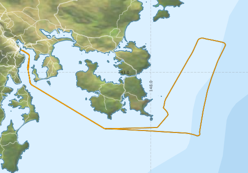
Voyage extents: 43° 19.4' S to 42° 49.6' S 147° 20.3' E to 148° 22.7' E Get voyage track shapefile Get CSV
Marlin Metadata:-
Cruise Summary Report at SeaDataNet:-
Participants - on ship:-
| Name | Role | Organisation | Project |
|---|---|---|---|
| Rod Palmer | Voyage Manager | Marine National Facility | Voyage Management on RV Investigator |
This list includes those that may have only been on part of the voyage. See voyage reports on 'Reports and Maps' tab for details.
Marine National Facility Reports - plans, summaries and data processing
- View Survey map
Publications, reports and datasets from this voyage.
Dataset
- Palmer, Rod; Boyd, Matt; Nau, Amy; Navidad, Cisco; Fox, Ruby (2024): IN2018_E01 Tasmanian Coast Bathymetry 10m - 210m Multi-resolution AusSeabed products. v1. CSIRO. Data Collection. 10.25919/xraw-z434
Search for publications, reports and datasets from this and other voyages
Data publishing
This is a list of online datasets hosted by CSIRO. Other processed datasets hosted by collaborating organisations may be found on the 'Metadata' or "Reports, Publications and Maps' tab.
Use the Get data link on the right to extract data using the NCMI Data Trawler.
| Data Stream | Data Summary | Get data | ||||||||||
|---|---|---|---|---|---|---|---|---|---|---|---|---|
| Multibeam echosounder |
|
Get Data from Trawler Geophysical Survey and Mapping data acquisition and processing report |
||||||||||
| Singlebeam echosounder |
|
Get Data from Trawler Geophysical Survey and Mapping acquisition report |
| ID | When (UTC) | Lat | Long | Instrument | Identifier | Action | Log | Subject / Comment |
|---|
Deployments - None have been recorded in the Data Trawler.