Voyage details and related metadata, reports, events and data.
IN2017_E02
- is a Marine National Facility ![]() voyage
voyage
Title: MNF equipment sea trials
Voyage details on MNF site: https://mnf.csiro.au/en/Voyages/IN2017_E02
Period: 2017-03-31 05:20 to 2017-04-02 08:00 UTC
Duration: 2.11 days
From: Hobart To: Hobart
Region: South Tasmanian coast
Ship: Investigator (RV) [details]
Description: Gear Trials
Leader: Don McKenzie (MNF)
Project: Investigator - general vessel operations, gear trials, etc. [details] Primary
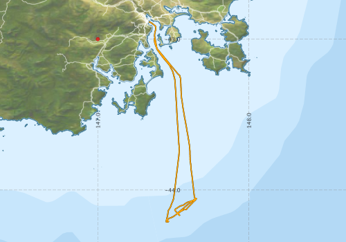
Voyage extents: 44° 12.7' S to 42° 53.2' S 147° 20.3' E to 147° 39.3' E Get voyage track shapefile Get CSV
Marlin Metadata:-
Cruise Summary Report at SeaDataNet:-
Participants - on ship:-
| Name | Role | Organisation | Project |
|---|---|---|---|
| Don McKenzie | Voyage Manager | Marine National Facility | Voyage Management on RV Investigator |
| Matt Kimber | Deputy Voyage Manager | Marine National Facility | Voyage Management on RV Investigator |
This list includes those that may have only been on part of the voyage. See voyage reports on 'Reports and Maps' tab for details.
Marine National Facility Reports - plans, summaries and data processing
-
IN2017_E02 Voyage Plan
- includes objectives, investigator details, proposed data collection, voyage track and equipment to be used.
- View Survey map
Publications, reports and datasets from this voyage.
Dataset
- McKenzie, Don (ex-CSIRO); Watts, Dave; Navidad, Cisco; Boyd, Matt; Fox, Ruby (2024): IN2017_E02 Southeast Tasmania Bathymetry 10m - 210m Multi-resolution AusSeabed products. v1. CSIRO. Data Collection. 10.25919/zgqj-ej28
Journal Article
- O’Hara, Timothy D.,Hugall, Andrew F.,Haines, Margaret L.,Weber, Alexandra A.-T.,Eichsteller, Angelina,Brogger, Martin I.,Eléaume, Marc,Fujita, Toshihiko,Kongsrud, Jon A.,Martinez Arbizu, Pedro,Mills, Sadie,Olbers, Jennifer M.,Paulay, Gustav,Ramil, Fran,Samadi, Sarah,Sands, Chester J.,Sellanes, Javier,Solis-Marin, Francisco A.,Moussalli, Adnan (2025) Spatiotemporal faunal connectivity across global sea floors. Nature pp-. 10.1038/s41586-025-09307-1
- Verhoeff, Tristan Joseph (2025) Dallithyris and Liothyrella from southeastern Australia with description of a new species of Liothyrella (Brachiopoda: Terebratulidae). Australian Journal of Taxonomy pp1-21. 10.54102/ajt.96zkl
Search for publications, reports and datasets from this and other voyages
Data publishing
This is a list of online datasets hosted by CSIRO. Other processed datasets hosted by collaborating organisations may be found on the 'Metadata' or "Reports, Publications and Maps' tab.
Use the Get data link on the right to extract data using the NCMI Data Trawler.
| Data Stream | Data Summary | Get data | ||||||||||
|---|---|---|---|---|---|---|---|---|---|---|---|---|
| Gravity Measurements |
|
Get Data from Trawler Geophysical Survey and Mapping acquisition report |
||||||||||
| Multibeam echosounder |
|
Get Data from Trawler Geophysical Survey and Mapping acquisition report |
||||||||||
| Radon measurements |
|
Get Data from Trawler Download RV Investigator Radon dataset (XLSX) |
||||||||||
| Singlebeam echosounder |
|
Get Data from Trawler Geophysical Survey and Mapping acquisition report |
| ID | When (UTC) | Lat | Long | Instrument | Identifier | Action | Log | Subject / Comment |
|---|
Deployments - None have been recorded in the Data Trawler.