Voyage details and related metadata, reports, events and data.
IN2014_E01
- is a Marine National Facility ![]() voyage
voyage
Title: Delivery voyage of RV Investigator from Singapore to Hobart.
Period: 2014-08-24 07:00 to 2014-09-09 00:00 UTC
Duration: 15.71 days
From: Singapore To: Hobart
Region: Sunda Strait, Indian Ocean, Cape Leeuwin.
Ship: Investigator (RV) [details]
Description: RV Investigator delivery voyage IN2014_E01. Delivery voyage of RV Investigator from Singapore to Hobart. The voyage took place between the 24th August and the 9th of September, 2014 from Singapore to Hobart. It is not intended that the ship be scheduled or conduct any research activities during the delivery voyage as the crew will not have been trained to operate the scientific winches and as such there will be no procedures established under the safety management system as these activities are planned to be established in slow time after arrival in Hobart. Also the number of personnel on board will need to be kept to a minimum during the voyage. The Voyage Objectives are: 1. To deliver a safe platform to Hobart. 2. Crew familiarisation with the ship and equipment with the ship underway. 3. Furthering of the implementation of ISM noting that the ship will have an interim Safety Management Certificate. This will include such things: 4. Furthering the production and testing of the Ship Security Plan for which an interim certificate only will have been issued priority to departure. 5. Identifying other equipment considered necessary for the safe operation of the ship and which will be required to conduct research. 6. Establishing shipboard routines 7. Conducting steady steaming trials to establish fuel and oil consumption data. 8. Deviation to course to allow aerial footage during daylight hours - within 50nm of Fremantle. 9. Operations team delivery voyage tasks are all focussed around preparation for arrival in Hobart and the beginning of Group 6 phases 4, 5 & 6: 10. The Ops team will participate in musters and drills and provide input and advice where appropriate related to support staff and science personnel. 11. Assist with the development of ship inductions for visitors and voyage participants so that these are ready for arrival in Hobart. 12. Familiarisation with the layout of the vessel. The key to planning safe and efficient operations and voyages is knowing the ship and how it works. The ops team will be responsible for training tour guides for WTP and for introducing MNF support staff to the vessel from arrival in Hobart. There are also areas in the Voyage Manuals and Documents that have been unable to be completed as the team is not familiar with the layout of the accommodation and recreation areas and the laboratories and science areas. 13. Laboratories and science areas. The ops team have already begun planning and preparation for the sea trials and trial voyages out of Hobart. Familiarisation and testing to be able to advise potential trial voyage participants on equipment setup, location or facilities without ever having seen the ship. 14. Fairing the towed body cable. The end few hundred metres of the towed body cable requires fairing to be fitted before the sea trials. The workshop has sent the required equipment to the ship and the Ops team members have agreed to spend a few hours each day taking turns at the task. 15. Confirm container loading plan. 16. Assess the options for makeup air and exhaust management for the radioisotope container. 17. MNF Support staff groups (Electronics, Data Processing, GSM) will all be undertaking setup, testing and familiarisation of systems and equipment during the delivery voyage. Also identifying any modifications/rectifications which may need addressing during Phase 4 work in Hobart. 18. Opportunistic swath mapping if appropriate. Please see Voyage Plan for full details.
Leader: D. McKenzie (MNF, CSIRO)
Project: Investigator - general vessel operations, gear trials, etc. [details] Primary

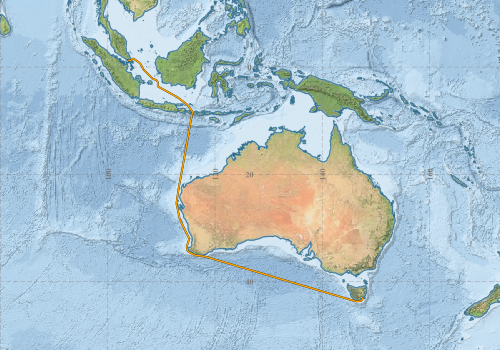
Map derived from waypoints
Voyage extents: 43° 42.3' S to 1° 37.4' N 103° 48.0' E to 147° 30.0' E Get voyage track shapefile Get CSV
Marlin Metadata:-
Cruise Summary Report at SeaDataNet:-
Participants - on ship:-
| Name | Role | Organisation | Project |
|---|---|---|---|
| Brett Muir | MIG Support | Marine National Facility | Seagoing Instrumentation Team |
| Don McKenzie | Science Operations Manager | Marine National Facility | Voyage Management on RV Investigator |
| Hugh Barker | DAP Support | Marine National Facility | Data Acquisition and Processing |
| Lisa Woodward | Operations Officer | Marine National Facility | Voyage Management on RV Investigator |
| Stephen McCullum | Ship Manager/ Voyage Manager | Marine National Facility | Voyage Management on RV Investigator |
| Stephen Thomas | MIG Support | Marine National Facility | Seagoing Instrumentation Team |
| Stuart Edwards | GSM Support | Marine National Facility | Geophysical Survey and Mapping |
| Tara Martin | GSM Support | Marine National Facility | Geophysical Survey and Mapping |
| Tegan Sime | Operations Officer | Marine National Facility | Voyage Management on RV Investigator |
This list includes those that may have only been on part of the voyage. See voyage reports on 'Reports and Maps' tab for details.
Marine National Facility Reports - plans, summaries and data processing
Search for publications, reports and datasets from this and other voyages
Data publishing - No datasets have been published
Deployments by start time:- Click on column header to sort. Use link on 'Deployment' to see full details. Use the CSV button at the bottom to export data (tab delimited).
Search for deployments from this voyage and others
| Deployment | Operation | Station | Cast | Gear | Project | Start and end times | Start Location | End Location | Depth range | Max Depth | Description | |||
|---|---|---|---|---|---|---|---|---|---|---|---|---|---|---|
| Multibeam echosounder [details] | Kongsberg EM122 12kHz multibeam echosounder | 2014-08-28 07:08 | 2014-09-01 18:47 | -11.1671 | 115.2911 | -30.9514 | 114.6676 | 7202.6 | ||||||
