Voyage details and related metadata, reports, events and data.
FR 09/2001
(alternative identifier: FR200109)
- is a Marine National Facility ![]() voyage
voyage
Period: 2001-11-13 00:00 to 2001-12-05 00:00 Local
Duration: 22.00 days
From: Brisbane To: Brisbane
Region: Eastern Lord Howe Rise, Tasman Sea; New Caledonian waters.
Ship: Franklin [details]
Description:
Geophysics, geochemistry and sedimentology associated with an inferred large gas hydrate deposit, eastern Lord Howe Rise, Tasman Sea (FAUST 3).
Seismic mapping of basin sequences, sediment diapirs and bottom simulating reflectors within the Australian and New Caledonian/French seabed jurisdictions; Core to help determine the origin and composition of gas on the Lord Howe Rise, especially in any identified seafloor structures above sediment diapirs; Ground-truth seismic data by sampling older outcropping sequences; Core to establish the composition, character and climate history of shallow sediment of Holocene and Pleistocene age.
Leader: Dr Neville Exon (AGSO)
Project: National Facility External Users: N. Exon (Geoscience Australia - [ AGSO pre 2001]) [details]
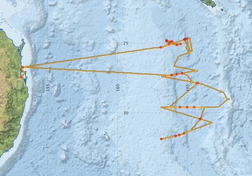
Voyage extents: 31° 54.9' S to 24° 36.6' S 153° 04.7' E to 167° 58.7' E Get voyage track shapefile Get CSV
Marlin Metadata:-
Participants - on ship:-
| Name | Role | Organisation |
|---|---|---|
| Craig Wintle | Mechanical Technican | Geoscience Australia |
| David Holdway | ElectronicsTechnican | Geoscience Australia |
| Jon Stratton | Geological Technican | Geoscience Australia |
| Kirsten Perry | Sedimentologist | James Cook University |
| Lindsay Pender | Computing | |
| Lyndon O'Grady | Geological Technican | Geoscience Australia |
| Melissa Fellows | Sedimentologist | Geoscience Australia |
| Neville Exon | Chief Scientist | Geoscience Australia |
| Patrick Mitts | Geochemist | Moss Landing Marine Labs, USA |
| Peter Hill | Geophysicist | Geoscience Australia |
| Stephen Thomas | Electronics | CSIRO Marine Research |
| Yves Lafoy | Geoscientist |
This list includes those that may have only been on part of the voyage. See voyage reports on 'Reports and Maps' tab for details.
Marine National Facility Reports - plans, summaries and data processing
-
FR200109 Voyage Summary
- includes preliminary results, voyage narrative, types of data collected with C77/ROSCOP codes.
-

Publications, reports and datasets from this voyage.
Journal Article
- Exon, N. F.,Lafoy, Y.,Hill, P. J.,Dickens, G. R.,Pecher, I. (2007) Geology and petroleum potential of the Fairway Basin in the Tasman Sea. Australian Journal of Earth Sciences 54 pp629-645. 10.1080/08120090701305194
Report
- Exon, N., Hill, P., Lafoy, Y., Fellows, M., Perry, K., Mills, P., Howe, R., Chaproniere, G., Dickens, G., Ussler, B., Paull, C. (2004) Geology of the Fairway and New Caledonia Basins in the Tasman Sea: Sediment, Pore Water, Diapirs and Bottom Simulating Reflectors ( Franklin Cruise FR9/01 and Geoscience Australia Survey 232). Record 2004/026. Geoscience Australia, Canberra. External link to reference
Search for publications, reports and datasets from this and other voyages
Data publishing
This is a list of online datasets hosted by CSIRO. Other processed datasets hosted by collaborating organisations may be found on the 'Metadata' or "Reports, Publications and Maps' tab.
Use the Get data link on the right to extract data using the NCMI Data Trawler.
| Data Stream | Data Summary | Get data | ||||||||||||||
|---|---|---|---|---|---|---|---|---|---|---|---|---|---|---|---|---|
| ADCP Data |
|
Get Data from Trawler Download NetCDF dataset fr0109adcpCDF.zip Download dataset 8.6 / 1.9 Mb Processing report for this dataset |
||||||||||||||
| Underway |
|
Get Data from Trawler |
Deployments by start time:- Click on column header to sort. Use link on 'Deployment' to see full details. Use the CSV button at the bottom to export data (tab delimited).
Search for deployments from this voyage and others
| Deployment | Operation | Station | Cast | Gear | Project | Start and end times | Start Location | End Location | Depth range | Max Depth | Description | |||
|---|---|---|---|---|---|---|---|---|---|---|---|---|---|---|
| Underway System [details] | Anemometer,Anemometer,Anemometer,Barometer,Gyro-MK 10,Humidity probe,Licor-UWQ 4653,RIMCO vane driving potentiometer,RIMCO vane driving potentiometer,Ships log,Simrad EA500 Echosounder,Temperature sensor-AD590J,ThermoSalinoGraph (TSG)-Franklin,ThermoSalinoGraph (TSG)-Franklin | 142 | 2001-11-12 00:00 | 2001-12-05 23:59 | -27.4467 | 153.0770 | -27.4012 | 153.1520 | ||||||
| ADCP Data [details] | RDI VM-150 Acoustic Doppler current profiler | 142 | 2001-11-13 05:40 | 2001-12-05 17:20 | -26.7280 | 153.2010 | -26.7190 | 153.2250 | 320.8 | |||||
| Sediment Sampling [details] | 232/GC15 | 142 | -31.5932 | 164.4106 | ||||||||||
| Sediment Sampling [details] | 232/GC27 | 142 | -27.2945 | 163.8750 | ||||||||||
| Sediment Sampling [details] | 232/GC24 | 142 | -27.8668 | 165.7167 | ||||||||||
| Sediment Sampling [details] | 232/GC05 | 142 | -24.9164 | 163.7792 | ||||||||||
| Sediment Sampling [details] | 232/GC16 | 142 | -31.4748 | 164.7422 | ||||||||||
| Sediment Sampling [details] | 232/GC04 | 142 | -24.8030 | 163.4998 | ||||||||||
| Sediment Sampling [details] | 232/GC06 | 142 | -24.8833 | 163.8996 | ||||||||||
| Sediment Sampling [details] | 232/GC03 | 142 | -24.8617 | 163.5013 | ||||||||||
| Sediment Sampling [details] | 232/GC14 | 142 | -31.6558 | 164.1414 | ||||||||||
| Sediment Sampling [details] | 232/GC11 | 142 | -24.7380 | 164.8192 | ||||||||||
| Sediment Sampling [details] | 232/GC02 | 142 | -25.0618 | 163.6670 | ||||||||||
| Sediment Sampling [details] | 232/GC08 | 142 | -25.1352 | 164.2252 | ||||||||||
| Sediment Sampling [details] | 232/GC26 | 142 | -27.2290 | 164.2405 | ||||||||||
| Sediment Sampling [details] | 232/GC21 | 142 | -29.5963 | 165.4768 | ||||||||||
| Sediment Sampling [details] | 232/GC25 | 142 | -27.1630 | 164.6090 | ||||||||||
| Sediment Sampling [details] | 232/GC23 | 142 | -29.5981 | 164.4631 | ||||||||||
| Sediment Sampling [details] | 232/GC10 | 142 | -24.7388 | 164.7690 | ||||||||||
| Sediment Sampling [details] | 232/GC22 | 142 | -29.5977 | 164.9752 | ||||||||||
| Sediment Sampling [details] | 232/GC01 | 142 | -25.3112 | 163.0792 | ||||||||||
| Sediment Sampling [details] | 232/GC12 | 142 | -24.6899 | 164.9639 | ||||||||||
| Sediment Sampling [details] | 232/GC18 | 142 | -30.4478 | 165.9055 | ||||||||||
| Sediment Sampling [details] | 232/GC13 | 142 | -31.8835 | 163.1335 | ||||||||||
| Sediment Sampling [details] | 232/GC09 | 142 | -25.0618 | 164.5008 | ||||||||||