Voyage details and related metadata, reports, events and data.
FR 10/98
(alternative identifier: FR199810)
- is a Marine National Facility ![]() voyage
voyage
Period: 1998-07-30 00:00 to 1998-08-18 00:00 Local
Duration: 19.00 days
From: Portland To: Hobart
Region: Great Australian Bight plus Tasmanian waters
Ship: Franklin [details]
Description: Franklin voyage FR 10/98 was the second of two research cruises to study seasonal variability of the position and intensity of the Subtropical Front south of Australia, in the region of the Great Australian Bight and the west and south coasts of Tasmania. Voyage objectives included to study the persistence and regional continuity of the Front, to determine the associated seasonal variation in temperature gradient, velocity field, transport across it, and to determine the continuity of transport from the eastern Indian Ocean to the Tasman Sea. The previous related cruise was voyage FR 02/98.
Leader: M. Tomczak (Flinders University)
Project: National Facility External Users: M. Tomczak (Flinders University) [details]
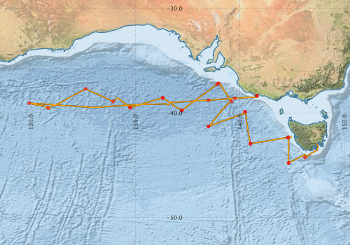
Voyage extents: 44° 48.1' S to 37° 06.5' S 119° 48.8' E to 147° 29.8' E Get voyage track shapefile Get CSV
Marlin Metadata:-
Metadata from OBIS Australia datasets:- biological data is published via the OBIS-AU IPT server and delivered to one or more of OBIS, ALA and GBIF
Download from OBIS Australia IPT View at - Ocean Biodiversity Information System (OBIS) Atlas of Living Australia (ALA) GBIF
Participants - on ship:-
| Name | Role | Organisation |
|---|---|---|
| Charles James | FIAMS | |
| Duncan Tippins | FIAMS | |
| Erik Madsen | CSIRO ORV | |
| Ian Helmond | CSIRO ORV | |
| Kevin Miller | CSIRO ORV | |
| Lindsay Pender | Cruise Manager | CSIRO ORV |
| Mark Hemer | FIAMS | |
| Mark Rayner | CSIRO ORV | |
| Matthias Tomczak | Chief Investigator | FIAMS |
| Rohan Clarke | Monash University |
This list includes those that may have only been on part of the voyage. See voyage reports on 'Reports and Maps' tab for details.
Marine National Facility Reports - plans, summaries and data processing
-
FR199810 Voyage Summary
- includes preliminary results, voyage narrative, types of data collected with C77/ROSCOP codes.
-

Publications, reports and datasets from this voyage.
IPT Resource
- Seabird observations in Australian and adjacent seas from voyages of the RV Franklin, RV Southern Surveyor, Southern Supporter and RV Aurora Australis (1988-2012) (Darwin Core Archive) External link to reference
Search for publications, reports and datasets from this and other voyages
Data publishing
This is a list of online datasets hosted by CSIRO. Other processed datasets hosted by collaborating organisations may be found on the 'Metadata' or "Reports, Publications and Maps' tab.
Use the Get data link on the right to extract data using the NCMI Data Trawler.
| Data Stream | Data Summary | Get data | ||||||||||||||
|---|---|---|---|---|---|---|---|---|---|---|---|---|---|---|---|---|
| ADCP Data |
|
Get Data from Trawler Download ASCII dataset - fr9810adcp.zip Download NetCDF dataset fr9810adcp.zip |
||||||||||||||
| Marine biodiversity observations and/or samples |
|
Get Data from Trawler |
||||||||||||||
| CTD profile |
|
Get Data from Trawler |
||||||||||||||
| Hydrology |
|
Get Data from Trawler Processing report for this dataset |
||||||||||||||
| Towed CTD |
|
Get Data from Trawler Download FR199810 Seasoar data |
||||||||||||||
| Underway |
|
Get Data from Trawler |
Deployments by start time:- Click on column header to sort. Use link on 'Deployment' to see full details. Use the CSV button at the bottom to export data (tab delimited).
Search for deployments from this voyage and others
| Deployment | Operation | Station | Cast | Gear | Project | Start and end times | Start Location | End Location | Depth range | Max Depth | Description | |||
|---|---|---|---|---|---|---|---|---|---|---|---|---|---|---|
| Underway System [details] | Anemometer,Anemometer,Anemometer,Barometer,Gyro-MK 10,Humidity probe,Licor-UWQ 4653,RIMCO vane driving potentiometer,RIMCO vane driving potentiometer,Ships log,Simrad EA500 Echosounder,Temperature sensor-AD590J,ThermoSalinoGraph (TSG),ThermoSalinoGraph (TSG) | 124 | 1998-07-30 00:00 | 1998-08-17 23:55 | -38.3405 | 141.6270 | -42.8863 | 147.3380 | ||||||
| ADCP Data [details] | RDI VM-150 Acoustic Doppler current profiler | 124 | 1998-07-30 00:20 | 1998-08-17 21:20 | -38.3620 | 141.6690 | -43.0930 | 147.4130 | 408.8 | |||||
| CTD Cast / Hydrology [details] | 1 | Cast 1 | 124 | 1998-07-30 12:23 | 1998-07-30 13:41 | -38.5988 | 139.5042 | -38.5933 | 139.5378 | 0 | ||||
| CTD Cast / Hydrology [details] | 1 | Cast 2 | 124 | 1998-07-31 04:02 | 1998-07-31 05:24 | -38.7815 | 136.9967 | -38.8085 | 137.0118 | 0 | ||||
| CTD Cast / Hydrology [details] | 1 | Cast 3 | 124 | 1998-08-04 10:02 | 1998-08-04 11:11 | -39.0665 | 119.8263 | -39.0762 | 119.8153 | 0 | ||||
| CTD Cast / Hydrology [details] | 1 | Cast 4 | 124 | 1998-08-05 17:43 | 1998-08-05 19:02 | -39.5267 | 121.6355 | -39.5373 | 121.6163 | 0 | ||||
| CTD Cast / Hydrology [details] | 1 | Cast 5 | 124 | 1998-08-06 21:35 | 1998-08-06 22:49 | -37.6883 | 125.2317 | -37.6887 | 125.2285 | 0 | ||||
| CTD Cast / Hydrology [details] | 1 | Cast 6 | 124 | 1998-08-07 17:34 | 1998-08-07 18:54 | -38.9135 | 127.8532 | -38.9183 | 127.8508 | 0 | ||||
| CTD Cast / Hydrology [details] | 1 | Cast 7 | 124 | 1998-08-08 09:25 | 1998-08-08 10:33 | -39.4930 | 129.5007 | -39.4878 | 129.4900 | 0 | ||||
| Towed CTD [details] | SeaSoar | 124 | 1998-08-08 09:51 | 1998-08-08 22:21 | -39.4877 | 129.4993 | -38.8790 | 131.4972 | 300 | Leg: 05 | ||||
| CTD Cast / Hydrology [details] | 1 | Cast 8 | 124 | 1998-08-09 06:50 | 1998-08-09 08:11 | -38.5537 | 132.6185 | -38.5618 | 132.6075 | 0 | ||||
| Towed CTD [details] | SeaSoar | 124 | 1998-08-09 07:42 | 1998-08-09 20:01 | -38.5627 | 132.6300 | -39.6223 | 134.2050 | 302 | Leg: 06 | ||||
| CTD Cast / Hydrology [details] | 1 | Cast 9 | 124 | 1998-08-09 22:55 | 1998-08-10 00:07 | -39.7592 | 134.4282 | -39.7550 | 134.4287 | 0 | ||||
| Towed CTD [details] | SeaSoar | 124 | 1998-08-09 23:30 | 1998-08-10 11:54 | -39.7515 | 134.4588 | -38.5922 | 135.9988 | 300 | Leg: 07 | ||||
| CTD Cast / Hydrology [details] | 1 | Cast 10 | 124 | 1998-08-11 05:02 | 1998-08-11 06:33 | -37.1622 | 137.9578 | -37.1608 | 137.9703 | 0 | ||||
| Towed CTD [details] | SeaSoar | 124 | 1998-08-11 06:36 | 1998-08-11 19:01 | -37.2348 | 137.8442 | -38.4187 | 138.8692 | 300 | Leg: 08 | ||||
| Towed CTD [details] | SeaSoar | 124 | 1998-08-11 23:08 | 1998-08-12 11:32 | -38.9067 | 139.1990 | -40.1985 | 137.9268 | 300 | Leg: 09 | ||||
| CTD Cast / Hydrology [details] | 1 | Cast 11 | 124 | 1998-08-12 22:50 | 1998-08-12 23:49 | -41.2970 | 136.9957 | -41.2907 | 136.9923 | 0 | ||||
| Towed CTD [details] | SeaSoar | 124 | 1998-08-12 23:04 | 1998-08-13 11:27 | -41.2798 | 136.9957 | -40.5482 | 139.0138 | 300 | Leg: 10 | ||||
| CTD Cast / Hydrology [details] | 1 | Cast 12 | 124 | 1998-08-13 22:38 | 1998-08-13 23:37 | -39.8867 | 140.4958 | -39.8868 | 140.4903 | 0 | ||||
| Towed CTD [details] | SeaSoar | 124 | 1998-08-13 22:49 | 1998-08-14 11:12 | -39.8828 | 140.4925 | -41.5158 | 140.7440 | 300 | Leg: 11 | ||||
| CTD Cast / Hydrology [details] | 1 | Cast 13 | 124 | 1998-08-14 23:38 | 1998-08-15 00:35 | -42.9455 | 141.0038 | -42.9470 | 141.0032 | 0 | ||||
| Towed CTD [details] | SeaSoar | 124 | 1998-08-14 23:52 | 1998-08-15 12:09 | -42.9422 | 141.0095 | -42.5788 | 143.1815 | 300 | Leg: 12 | ||||
| CTD Cast / Hydrology [details] | 1 | Cast 14 | 124 | 1998-08-16 00:53 | 1998-08-16 01:51 | -42.3473 | 144.5777 | -42.3450 | 144.5818 | 0 | ||||
| Towed CTD [details] | SeaSoar | 124 | 1998-08-16 01:22 | 1998-08-16 13:42 | -42.3303 | 144.6365 | -44.0048 | 144.6617 | 300 | Leg: 13 | ||||
| CTD Cast / Hydrology [details] | 1 | Cast 15 | 124 | 1998-08-16 20:45 | 1998-08-16 21:50 | -44.8023 | 144.6720 | -44.7797 | 144.6705 | 0 | ||||
| Towed CTD [details] | SeaSoar | 124 | 1998-08-16 21:00 | 1998-08-17 06:55 | -44.7767 | 144.6723 | -43.9677 | 146.2200 | 300 | Leg: 14 | ||||
| CTD Cast / Hydrology [details] | 1 | Cast 16 | 124 | 1998-08-17 09:50 | 1998-08-17 10:51 | -44.2633 | 146.2385 | -44.2637 | 146.2325 | 0 | ||||