Voyage details and related metadata, reports, events and data.
FR 07/98
(alternative identifier: FR199807)
- is a Marine National Facility ![]() voyage
voyage
Period: 1998-05-30 00:00 to 1998-06-08 00:00 Local
Duration: 9.00 days
From: Portland To: Melbourne
Region: Victorian waters/Bass Strait
Ship: Franklin [details]
Description: Cruise FR 07/98 (cruise 3 of 4) was undertaken for the first winter ichthyoplankton survey including correlation with physical and chemical oceanographic features. Area sampled comprised the Victorian coast between Gabo Island and Portland, south to 32 nautical miles offshore. Survey methods included CTDs, EZ and bongo net tows. Water samples for nutrient analysis, sigma-t, temperature, dissolved oxygen, fluorescence, and ichtyoplankton samples were collected for on board and laboratory analyses. Related cruises are FR 02/97 & FR 09/98.
Leader: F. Neira (Victorian Fisheries Res. Inst.)
Project: National Facility External Users: F. Neira (Victorian Fisheries Res. Inst.) [details]
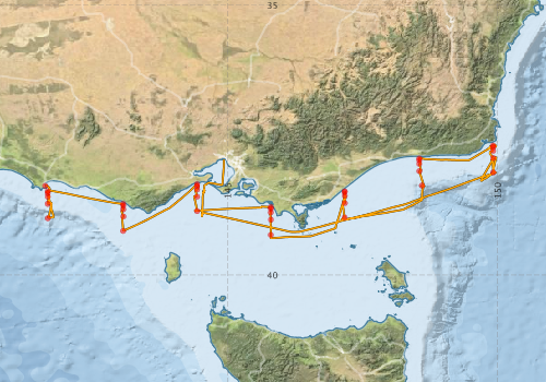
Voyage extents: 39° 18.9' S to 37° 35.4' S 141° 37.1' E to 149° 58.6' E Get voyage track shapefile Get CSV
Marlin Metadata:-
Metadata from OBIS Australia datasets:- biological data is published via the OBIS-AU IPT server and delivered to one or more of OBIS, ALA and GBIF
Download from OBIS Australia IPT View at - Ocean Biodiversity Information System (OBIS) Atlas of Living Australia (ALA) GBIF
Download from OBIS Australia IPT View at - Ocean Biodiversity Information System (OBIS) Atlas of Living Australia (ALA) GBIF
Participants - on ship:-
| Name | Role | Organisation |
|---|---|---|
| Alan Poole | CSIRO ORV | |
| David MacKeown | MAFRI | |
| Erik Madsen | CSIRO ORV | |
| Francisco Neira | Chief Investigator | Marine and Freshwater Resources Institute MAFRI |
| Geoff Nicholson | MAFRI | |
| Lindsay Pender | Cruise Manager | CSIRO ORV |
| Martin Lourey | MAFRI | |
| Paul Hamer | MAFRI | |
| Simon Conron | MAFRI | |
| Val Latham | CSIRO ORV |
This list includes those that may have only been on part of the voyage. See voyage reports on 'Reports and Maps' tab for details.
Marine National Facility Reports - plans, summaries and data processing
-
FR199807 Voyage Summary
- includes preliminary results, voyage narrative, types of data collected with C77/ROSCOP codes.
-

Publications, reports and datasets from this voyage.
IPT Resource
- IMOS - Larval Fish Sub-Facility - Database of Marine Larval Fish Assemblages in Australian temperate and subtropical waters (1983 - ongoing) (Darwin Core Archive) External link to reference
- Seabird observations in Australian and adjacent seas from voyages of the RV Franklin, RV Southern Surveyor, Southern Supporter and RV Aurora Australis (1988-2012) (Darwin Core Archive) External link to reference
Search for publications, reports and datasets from this and other voyages
Data publishing
This is a list of online datasets hosted by CSIRO. Other processed datasets hosted by collaborating organisations may be found on the 'Metadata' or "Reports, Publications and Maps' tab.
Use the Get data link on the right to extract data using the NCMI Data Trawler.
| Data Stream | Data Summary | Get data | ||||||||||||
|---|---|---|---|---|---|---|---|---|---|---|---|---|---|---|
| Marine biodiversity observations and/or samples |
|
Get Data from Trawler |
||||||||||||
| CTD profile |
|
Get Data from Trawler Processing report for this dataset |
||||||||||||
| Hydrology |
|
Get Data from Trawler Processing report for this dataset |
||||||||||||
| Underway |
|
Get Data from Trawler |
Deployments by start time:- Click on column header to sort. Use link on 'Deployment' to see full details. Use the CSV button at the bottom to export data (tab delimited).
Search for deployments from this voyage and others
| Deployment | Operation | Station | Cast | Gear | Project | Start and end times | Start Location | End Location | Depth range | Max Depth | Description | |||
|---|---|---|---|---|---|---|---|---|---|---|---|---|---|---|
| Underway System [details] | Anemometer,Anemometer,Anemometer,Barometer,Gyro-MK 10,Humidity probe,Licor-UWQ 4653,RIMCO vane driving potentiometer,RIMCO vane driving potentiometer,Ships log,Simrad EA500 Echosounder,Temperature sensor-AD590J,ThermoSalinoGraph (TSG),ThermoSalinoGraph (TSG) | 112 | 1998-05-30 00:00 | 1998-06-08 02:00 | -38.3487 | 141.6190 | -37.8588 | 144.9290 | ||||||
| CTD Cast / Hydrology [details] | 1 | Cast 1 | 112 | 1998-05-30 01:20 | 1998-05-30 01:28 | -38.4502 | 141.6662 | -38.4500 | 141.6667 | 0 | ||||
| CTD Cast / Hydrology [details] | 1 | Cast 2 | 112 | 1998-05-30 02:54 | 1998-05-30 03:05 | -38.4840 | 141.6667 | -38.4847 | 141.6695 | 0 | ||||
| CTD Cast / Hydrology [details] | 1 | Cast 3 | 112 | 1998-05-30 04:54 | 1998-05-30 05:03 | -38.5507 | 141.6673 | -38.5505 | 141.6698 | 0 | ||||
| CTD Cast / Hydrology [details] | 1 | Cast 4 | 112 | 1998-05-30 10:53 | 1998-05-30 11:03 | -38.6822 | 141.6648 | -38.6823 | 141.6657 | 0 | ||||
| CTD Cast / Hydrology [details] | 1 | Cast 5 | 112 | 1998-05-30 14:18 | 1998-05-30 14:30 | -38.9498 | 141.6682 | -38.9515 | 141.6718 | 0 | ||||
| CTD Cast / Hydrology [details] | 1 | Cast 6 | 112 | 1998-05-31 03:43 | 1998-05-31 03:50 | -38.6852 | 143.0645 | 0 | ||||||
| CTD Cast / Hydrology [details] | 1 | Cast 7 | 112 | 1998-05-31 05:07 | 1998-05-31 05:13 | -38.7167 | 143.0652 | -38.7160 | 143.0665 | 0 | ||||
| CTD Cast / Hydrology [details] | 1 | Cast 8 | 112 | 1998-05-31 06:26 | 1998-05-31 06:32 | -38.7823 | 143.0657 | -38.7815 | 143.0628 | 0 | ||||
| CTD Cast / Hydrology [details] | 1 | Cast 9 | 112 | 1998-05-31 09:05 | 1998-05-31 09:13 | -38.9158 | 143.0682 | -38.9152 | 143.0670 | 0 | ||||
| CTD Cast / Hydrology [details] | 1 | Cast 10 | 112 | 1998-05-31 11:36 | 1998-05-31 11:42 | -39.1838 | 143.0640 | -39.1852 | 143.0637 | 0 | ||||
| CTD Cast / Hydrology [details] | 1 | Cast 11 | 112 | 1998-05-31 22:00 | 1998-05-31 22:04 | -38.3165 | 144.4350 | -38.3168 | 144.4347 | 0 | ||||
| CTD Cast / Hydrology [details] | 1 | Cast 12 | 112 | 1998-05-31 23:16 | 1998-05-31 23:22 | -38.3503 | 144.4332 | -38.3513 | 144.4323 | 0 | ||||
| CTD Cast / Hydrology [details] | 1 | Cast 13 | 112 | 1998-06-01 00:35 | 1998-06-01 00:41 | -38.4173 | 144.4335 | 0 | ||||||
| CTD Cast / Hydrology [details] | 1 | Cast 14 | 112 | 1998-06-01 04:25 | 1998-06-01 04:33 | -38.5488 | 144.4348 | 0 | ||||||
| CTD Cast / Hydrology [details] | 1 | Cast 15 | 112 | 1998-06-01 07:37 | 1998-06-01 07:43 | -38.8157 | 144.4335 | -38.8155 | 144.4340 | 0 | ||||
| CTD Cast / Hydrology [details] | 1 | Cast 16 | 112 | 1998-06-01 21:38 | 1998-06-01 21:44 | -38.7417 | 145.7998 | -38.7410 | 145.8010 | 0 | ||||
| CTD Cast / Hydrology [details] | 1 | Cast 17 | 112 | 1998-06-01 22:59 | 1998-06-01 23:05 | -38.7730 | 145.7997 | 0 | ||||||
| CTD Cast / Hydrology [details] | 1 | Cast 18 | 112 | 1998-06-02 00:27 | 1998-06-02 00:33 | -38.8408 | 145.7990 | -38.8393 | 145.7978 | 0 | ||||
| CTD Cast / Hydrology [details] | 1 | Cast 19 | 112 | 1998-06-02 02:23 | 1998-06-02 02:30 | -38.9742 | 145.8010 | -38.9723 | 145.8012 | 0 | ||||
| CTD Cast / Hydrology [details] | 1 | Cast 20 | 112 | 1998-06-02 05:20 | 1998-06-02 05:26 | -39.2568 | 145.7992 | -39.2567 | 145.7985 | 0 | ||||
| CTD Cast / Hydrology [details] | 1 | Cast 21 | 112 | 1998-06-02 21:42 | 1998-06-02 21:46 | -38.4498 | 147.1665 | -38.4500 | 147.1657 | 0 | ||||
| CTD Cast / Hydrology [details] | 1 | Cast 22 | 112 | 1998-06-02 22:40 | 1998-06-02 22:43 | -38.4665 | 147.1662 | -38.4667 | 147.1657 | 0 | ||||
| CTD Cast [details] | 1 | Cast 23 | 112 | 1998-06-03 00:00 | 1998-06-03 00:04 | -38.5330 | 147.1687 | -38.5317 | 147.1683 | 0 | ||||
| CTD Cast / Hydrology [details] | 1 | Cast 24 | 112 | 1998-06-03 01:45 | 1998-06-03 01:48 | -38.6678 | 147.1692 | 0 | ||||||
| CTD Cast / Hydrology [details] | 1 | Cast 25 | 112 | 1998-06-03 04:05 | 1998-06-03 04:11 | -38.9335 | 147.1663 | -38.9350 | 147.1610 | 0 | ||||
| CTD Cast / Hydrology [details] | 1 | Cast 26 | 112 | 1998-06-03 21:32 | 1998-06-03 21:50 | -38.3423 | 148.5977 | -38.3373 | 148.5997 | 0 | ||||
| CTD Cast / Hydrology [details] | 1 | Cast 27 | 112 | 1998-06-04 01:11 | 1998-06-04 01:17 | -38.0748 | 148.5497 | -38.0757 | 148.5475 | 0 | ||||
| CTD Cast / Hydrology [details] | 1 | Cast 28 | 112 | 1998-06-04 03:00 | 1998-06-04 03:06 | -37.9417 | 148.5487 | 0 | ||||||
| CTD Cast / Hydrology [details] | 1 | Cast 29 | 112 | 1998-06-04 04:27 | 1998-06-04 04:31 | -37.8740 | 148.5488 | -37.8737 | 148.5468 | 0 | ||||
| CTD Cast / Hydrology [details] | 1 | Cast 30 | 112 | 1998-06-04 05:45 | 1998-06-04 05:48 | -37.8413 | 148.5500 | -37.8397 | 148.5477 | 0 | ||||
| CTD Cast / Hydrology [details] | 1 | Cast 31 | 112 | 1998-06-04 21:31 | 1998-06-04 21:39 | -37.6002 | 149.9147 | -37.5995 | 149.9127 | 0 | ||||
| CTD Cast / Hydrology [details] | 1 | Cast 32 | 112 | 1998-06-05 00:11 | 1998-06-05 00:18 | -37.6335 | 149.9187 | -37.6338 | 149.9180 | 0 | ||||
| CTD Cast / Hydrology [details] | 1 | Cast 33 | 112 | 1998-06-05 05:35 | 1998-06-05 05:43 | -37.6995 | 149.9167 | -37.6992 | 149.9153 | 0 | ||||
| CTD Cast / Hydrology [details] | 1 | Cast 34 | 112 | 1998-06-05 07:56 | 1998-06-05 08:07 | -37.8322 | 149.9170 | -37.8310 | 149.9153 | 0 | ||||
| CTD Cast / Hydrology [details] | 1 | Cast 35 | 112 | 1998-06-05 09:39 | 1998-06-05 09:49 | -38.0993 | 149.9182 | -38.0998 | 149.9177 | 0 | ||||