Voyage details and related metadata, reports, events and data.
FR 06/98
(alternative identifier: FR199806)
- is a Marine National Facility ![]() voyage
voyage
Period: 1998-05-25 00:00 to 1998-05-29 00:00 Local
Duration: 4.00 days
From: Adelaide To: Portland
Region: South Australian waters
Ship: Franklin [details]
Description: Cruise FR 06/98 is the second cruise undertaken to conduct the geophysical survey of the continental and abyssal plain off the Eyre Peninsula. Eighteen seafloor magnetotelluric instruments were deployed on FR 04/98 and seventeen were recovered, the majority from the continental shelf, and others from the continental slope and abyssal plain. Instruments from the sites, all came back with significant amounts of sediment in pipes and housings. Sediments will be passed on to Adelaide University for consideration. The data return is above 90% and all instruments recorded at least a few days. Preliminary analyses of the data shows that the electrical conductivity anomaly that has been imaged on land extends out across the continental shelf towards the edge of the continental margin. We are confident of determining significant tectonic information from these data.
Leader: A. White (Flinders University)
Project: National Facility External Users: A. White (Flinders University) [details]
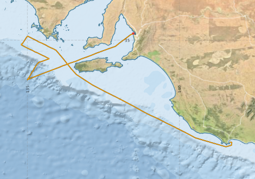
Voyage extents: 38° 29.5' S to 34° 46.7' S 134° 47.2' E to 141° 43.1' E Get voyage track shapefile Get CSV
Marlin Metadata:-
Participants - on ship:-
| Name | Role | Organisation |
|---|---|---|
| Adrian Costar | Flinders University | |
| Adrian Hitchman | Australian National University | |
| Alan Poole | CSIRO Marine Research | |
| Antony White | Chief Scientist | Flinders University |
| Debbie Clarke | Flinders University | |
| F Lilley | Australian National University | |
| Graham Heinson | Flinders University | |
| Graham Hughes | Australian National University | |
| Lindsay Pender | Cruise Manager | CSIRO Marine Research |
| Paula Hahsey | Flinders University | |
| Satoru Yamaguchi | ANU and Kobe University | |
| Susan Mau | Flinders University |
This list includes those that may have only been on part of the voyage. See voyage reports on 'Reports and Maps' tab for details.
Marine National Facility Reports - plans, summaries and data processing
-
FR199806 Voyage Summary
- includes preliminary results, voyage narrative, types of data collected with C77/ROSCOP codes.
-

Search for publications, reports and datasets from this and other voyages
Data publishing
This is a list of online datasets hosted by CSIRO. Other processed datasets hosted by collaborating organisations may be found on the 'Metadata' or "Reports, Publications and Maps' tab.
Use the Get data link on the right to extract data using the NCMI Data Trawler.
| Data Stream | Data Summary | Get data | ||||||||||||
|---|---|---|---|---|---|---|---|---|---|---|---|---|---|---|
| Underway |
|
Get Data from Trawler |
Deployments by start time:- Click on column header to sort. Use link on 'Deployment' to see full details. Use the CSV button at the bottom to export data (tab delimited).
Search for deployments from this voyage and others
| Deployment | Operation | Station | Cast | Gear | Project | Start and end times | Start Location | End Location | Depth range | Max Depth | Description | |||
|---|---|---|---|---|---|---|---|---|---|---|---|---|---|---|
| Underway System [details] | Anemometer,Anemometer,Anemometer,Barometer,Gyro-MK 10,Humidity probe,Licor-UWQ 4653,RIMCO vane driving potentiometer,RIMCO vane driving potentiometer,Ships log,Simrad EA500 Echosounder,Temperature sensor-AD590J | 102 | 1998-05-24 23:00 | 1998-05-28 22:00 | -34.7782 | 138.4810 | -38.3382 | 141.6400 | ||||||