Voyage details and related metadata, reports, events and data.
FR 03/98
(alternative identifier: FR199803)
- is a Marine National Facility ![]() voyage
voyage
Period: 1998-03-19 00:00 to 1998-04-07 00:00 Local
Duration: 19.00 days
From: Hobart To: Portland
Region: Eastern Great Australian Bight
Ship: Franklin [details]
Description: Cruise FR 03/98 was undertaken to study cool water carbonates in the eastern Great Australian Bight (Ceduna Terrace). Cruise objectives included to characterise the sedimentary facies present; analyse the sea-floor waters; document the nature of the morphology of the area, particularly the shelf margin; document the systematics of bryozoans, molluscs, foraminifers, corals, brachiopods, crustaceans and ostrocods present; document the distribution, food-source and other parameters governing the distribution of the king crab; determine environmental parameters controlling distribution and abundance of biota present and ascertain water current parameters across the shelf and down the slope margin. All objectives achieved to varying degrees. Survey methods included CTDs, pipe and epibenthic sled dredges, grabs, precision depth profiles, seafloor photography, real-time underwater video system, and underway instrumentation. Water, biota, rock, mud and sediment samples were collected for on board and laboratory analyses.
Leader: Y. Bone (University of Adelaide) including other Pis
Project: National Facility External Users: Y. Bone (University of Adelaide) [details]
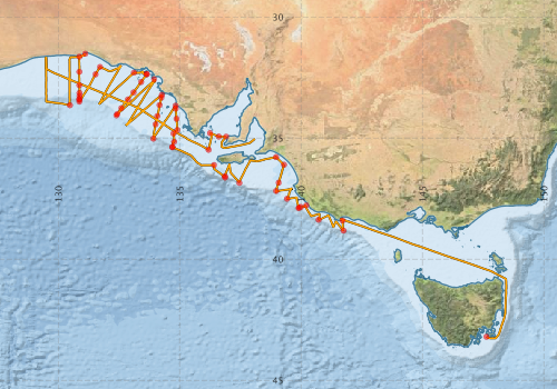
Voyage extents: 43° 16.0' S to 31° 30.7' S 129° 29.8' E to 148° 27.3' E Get voyage track shapefile Get CSV
Marlin Metadata:-
Metadata from OBIS Australia datasets:- biological data is published via the OBIS-AU IPT server and delivered to one or more of OBIS, ALA and GBIF
Download from OBIS Australia IPT View at - Ocean Biodiversity Information System (OBIS) Atlas of Living Australia (ALA) GBIF
Participants - on ship:-
| Name | Role | Organisation |
|---|---|---|
| Andrew Levings | Deakin | |
| Dave Vaudrey | Cruise Manager | CSIRO ORV |
| Erik Madsen | CSIRO ORV | |
| Kirsty Brown | University of Adelaide | |
| Kurt Kyser | Queens University, Canada | |
| Lindsay Collins | sediments | Curtin University |
| Noel James | Queens University, Canada | |
| Paul Gammon | Queens University, Canada | |
| Rolf Schmidt | University of Adelaide | |
| Ron Plaschke | CSIRO ORV | |
| Samanatha Ryan | University of Adelaide | |
| Yvonne Bone | Chief Investigator | University of Adelaide |
This list includes those that may have only been on part of the voyage. See voyage reports on 'Reports and Maps' tab for details.
Marine National Facility Reports - plans, summaries and data processing
-
FR199803 Voyage Summary
- includes preliminary results, voyage narrative, types of data collected with C77/ROSCOP codes.
-

Publications, reports and datasets from this voyage.
IPT Resource
- Seabird observations in Australian and adjacent seas from voyages of the RV Franklin, RV Southern Surveyor, Southern Supporter and RV Aurora Australis (1988-2012) (Darwin Core Archive) External link to reference
Journal Article
- Richardson, Laura E.,Kyser, T. Kurt,James, Noel P.,Bone, Yvonne (2009) Analysis of hydrographic and stable isotope data to determine water masses, circulation, and mixing in the eastern Great Australian Bight. Journal of Geophysical Research 114 pp-. 10.1029/2009jc005407
Search for publications, reports and datasets from this and other voyages
Data publishing
This is a list of online datasets hosted by CSIRO. Other processed datasets hosted by collaborating organisations may be found on the 'Metadata' or "Reports, Publications and Maps' tab.
Use the Get data link on the right to extract data using the NCMI Data Trawler.
| Data Stream | Data Summary | Get data | ||||||||||||
|---|---|---|---|---|---|---|---|---|---|---|---|---|---|---|
| Marine biodiversity observations and/or samples |
|
Get Data from Trawler |
||||||||||||
| CTD profile |
|
Get Data from Trawler Processing report for this dataset |
||||||||||||
| Hydrology |
|
Get Data from Trawler Processing report for this dataset |
||||||||||||
| Underway |
|
Get Data from Trawler |
Deployments by start time:- Click on column header to sort. Use link on 'Deployment' to see full details. Use the CSV button at the bottom to export data (tab delimited).
Search for deployments from this voyage and others
| Deployment | Operation | Station | Cast | Gear | Project | Start and end times | Start Location | End Location | Depth range | Max Depth | Description | |||
|---|---|---|---|---|---|---|---|---|---|---|---|---|---|---|
| Underway System [details] | Anemometer,Anemometer,Anemometer,Barometer,Gyro-MK 10,Humidity probe,Licor-UWQ 4653,RIMCO vane driving potentiometer,RIMCO vane driving potentiometer,Ships log,Simrad EA500 Echosounder,Temperature sensor-AD590J,ThermoSalinoGraph (TSG),ThermoSalinoGraph (TSG) | 141 | 1998-03-18 22:00 | 1998-04-06 21:00 | -43.2047 | 147.6350 | -35.0313 | 138.0970 | ||||||
| CTD Cast / Hydrology [details] | 1 | Cast 1 | 141 | 1998-03-21 03:03 | 1998-03-21 03:07 | -38.4062 | 141.7108 | -38.4050 | 141.7118 | 0 | ||||
| CTD Cast / Hydrology [details] | 1 | Cast 2 | 141 | 1998-03-21 06:27 | 1998-03-21 06:49 | -38.8202 | 141.7477 | -38.8180 | 141.7490 | 0 | ||||
| CTD Cast / Hydrology [details] | 1 | Cast 3 | 141 | 1998-03-21 18:12 | 1998-03-21 18:32 | -38.3760 | 140.7232 | -38.3753 | 140.7203 | 0 | ||||
| CTD Cast / Hydrology [details] | 1 | Cast 4 | 141 | 1998-03-22 03:15 | 1998-03-22 03:24 | -37.7758 | 140.2152 | -37.7778 | 140.2165 | 0 | ||||
| CTD Cast / Hydrology [details] | 1 | Cast 5 | 141 | 1998-03-22 05:17 | 1998-03-22 05:33 | -37.8478 | 139.9958 | -37.8458 | 139.9965 | 0 | ||||
| CTD Cast / Hydrology [details] | 1 | Cast 6 | 141 | 1998-03-22 08:44 | 1998-03-22 09:03 | -37.8730 | 139.9262 | -37.8738 | 139.9250 | 0 | ||||
| CTD Cast / Hydrology [details] | 1 | Cast 7 | 141 | 1998-03-22 10:12 | 1998-03-22 10:34 | -37.8897 | 139.8982 | -37.8910 | 139.8957 | 0 | ||||
| CTD Cast / Hydrology [details] | 1 | Cast 8 | 141 | 1998-03-22 17:17 | 1998-03-22 17:33 | -37.5097 | 139.4207 | -37.5125 | 139.4195 | 0 | ||||
| CTD Cast / Hydrology [details] | 1 | Cast 9 | 141 | 1998-03-23 07:06 | 1998-03-23 07:23 | -37.1880 | 138.9725 | -37.1890 | 138.9707 | 0 | ||||
| CTD Cast / Hydrology [details] | 1 | Cast 10 | 141 | 1998-03-23 10:53 | 1998-03-23 11:04 | -36.8413 | 139.0785 | -36.8430 | 139.0815 | 0 | ||||
| CTD Cast / Hydrology [details] | 1 | Cast 11 | 141 | 1998-03-23 15:38 | 1998-03-23 15:47 | -36.1015 | 139.2998 | -36.1027 | 139.3013 | 0 | ||||
| CTD Cast / Hydrology [details] | 1 | Cast 12 | 141 | 1998-03-23 18:37 | 1998-03-23 18:45 | -35.7868 | 138.9678 | -35.7873 | 138.9687 | 0 | ||||
| CTD Cast / Hydrology [details] | 1 | Cast 13 | 141 | 1998-03-24 09:27 | 1998-03-24 09:46 | -36.8518 | 137.4592 | -36.8503 | 137.4652 | 0 | ||||
| CTD Cast / Hydrology [details] | 1 | Cast 14 | 141 | 1998-03-24 20:15 | 1998-03-24 20:30 | -36.5733 | 136.8632 | -36.5762 | 136.8650 | 0 | ||||
| CTD Cast / Hydrology [details] | 1 | Cast 15 | 141 | 1998-03-24 22:43 | 1998-03-24 23:02 | -36.6303 | 136.8682 | -36.6318 | 136.8728 | 0 | ||||
| CTD Cast / Hydrology [details] | 1 | Cast 16 | 141 | 1998-03-25 02:55 | 1998-03-25 03:10 | -36.1150 | 136.4178 | -36.1140 | 136.4183 | 0 | ||||
| CTD Cast / Hydrology [details] | 1 | Cast 17 | 141 | 1998-03-25 15:33 | 1998-03-25 15:57 | -35.3797 | 134.6997 | -35.3782 | 134.6995 | 0 | ||||
| CTD Cast / Hydrology [details] | 1 | Cast 18 | 141 | 1998-03-25 16:55 | 1998-03-25 17:12 | -35.3622 | 134.7015 | -35.3635 | 134.7027 | 0 | ||||
| CTD Cast / Hydrology [details] | 1 | Cast 19 | 141 | 1998-03-25 20:32 | 1998-03-25 20:46 | -35.1527 | 134.7758 | -35.1530 | 134.7777 | 0 | ||||
| CTD Cast / Hydrology [details] | 1 | Cast 20 | 141 | 1998-03-25 23:09 | 1998-03-25 23:20 | -34.8152 | 134.7473 | -34.8130 | 134.7463 | 0 | ||||
| CTD Cast / Hydrology [details] | 1 | Cast 21 | 141 | 1998-03-26 00:51 | 1998-03-26 01:01 | -34.6655 | 134.9050 | -34.6627 | 134.9042 | 0 | ||||
| CTD Cast / Hydrology [details] | 1 | Cast 22 | 141 | 1998-03-26 03:50 | 1998-03-26 04:02 | -34.2038 | 134.8718 | -34.2022 | 134.8727 | 0 | ||||
| CTD Cast / Hydrology [details] | 1 | Cast 23 | 141 | 1998-03-26 07:13 | 1998-03-26 07:22 | -33.7880 | 134.8335 | -33.7858 | 134.8333 | 0 | ||||
| CTD Cast / Hydrology [details] | 1 | Cast 24 | 141 | 1998-03-26 08:32 | 1998-03-26 08:40 | -33.6665 | 134.8317 | -33.6657 | 134.8307 | 0 | ||||
| CTD Cast / Hydrology [details] | 1 | Cast 25 | 141 | 1998-03-26 19:27 | 1998-03-26 19:51 | -35.0233 | 133.9138 | -35.0245 | 133.9165 | 0 | ||||
| CTD Cast / Hydrology [details] | 1 | Cast 26 | 141 | 1998-03-27 02:34 | 1998-03-27 02:47 | -34.4348 | 134.0088 | -34.4342 | 134.0107 | 0 | ||||
| CTD Cast / Hydrology [details] | 1 | Cast 27 | 141 | 1998-03-27 05:13 | 1998-03-27 05:24 | -34.0878 | 134.0807 | -34.0892 | 134.0805 | 0 | ||||
| CTD Cast / Hydrology [details] | 1 | Cast 28 | 141 | 1998-03-27 08:23 | 1998-03-27 08:34 | -33.6387 | 134.1732 | -33.6402 | 134.1725 | 0 | ||||
| CTD Cast / Hydrology [details] | 1 | Cast 29 | 141 | 1998-03-27 10:36 | 1998-03-27 10:48 | -33.3348 | 134.2488 | -33.3347 | 134.2475 | 0 | ||||
| CTD Cast / Hydrology [details] | 1 | Cast 30 | 141 | 1998-03-27 11:59 | 1998-03-27 12:09 | -33.2155 | 134.2712 | -33.2145 | 134.2690 | 0 | ||||
| CTD Cast / Hydrology [details] | 1 | Cast 31 | 141 | 1998-03-28 20:35 | 1998-03-28 20:42 | -32.5773 | 133.9512 | -32.5775 | 133.9517 | 0 | ||||
| CTD Cast / Hydrology [details] | 1 | Cast 32 | 141 | 1998-03-29 10:03 | 1998-03-29 10:30 | -34.0617 | 132.3928 | -34.0662 | 132.3958 | 0 | ||||
| CTD Cast / Hydrology [details] | 1 | Cast 33 | 141 | 1998-03-29 11:53 | 1998-03-29 12:11 | -34.0043 | 132.4340 | 0 | ||||||
| CTD Cast / Hydrology [details] | 1 | Cast 35 | 141 | 1998-03-29 15:14 | 1998-03-29 15:27 | -33.7697 | 132.5935 | -33.7687 | 132.5968 | 0 | ||||
| CTD Cast / Hydrology [details] | 1 | Cast 36 | 141 | 1998-03-29 18:31 | 1998-03-29 18:43 | -33.4040 | 132.8705 | -33.4047 | 132.8715 | 0 | ||||
| CTD Cast / Hydrology [details] | 1 | Cast 37 | 141 | 1998-03-29 21:57 | 1998-03-29 22:09 | -33.1157 | 133.1003 | -33.1150 | 133.0982 | 0 | ||||
| CTD Cast / Hydrology [details] | 1 | Cast 38 | 141 | 1998-03-30 01:15 | 1998-03-30 01:24 | -32.6855 | 133.4128 | -32.6842 | 133.4123 | 0 | ||||
| CTD Cast / Hydrology [details] | 1 | Cast 39 | 141 | 1998-03-30 03:58 | 1998-03-30 04:09 | -32.3635 | 133.6525 | -32.3625 | 133.6517 | 0 | ||||
| CTD Cast / Hydrology [details] | 1 | Cast 40 | 141 | 1998-03-30 05:02 | 1998-03-30 05:11 | -32.3585 | 133.6347 | -32.3593 | 133.6335 | 0 | ||||
| CTD Cast / Hydrology [details] | 1 | Cast 41 | 141 | 1998-03-30 09:48 | 1998-03-30 09:58 | -32.3028 | 133.1158 | -32.3023 | 133.1155 | 0 | ||||
| CTD Cast / Hydrology [details] | 1 | Cast 42 | 141 | 1998-03-31 15:17 | 1998-03-31 15:27 | -32.0625 | 131.7203 | -32.0622 | 131.7212 | 0 | ||||
| CTD Cast / Hydrology [details] | 1 | Cast 43 | 141 | 1998-03-31 18:04 | 1998-03-31 18:14 | -32.3703 | 131.5363 | -32.3695 | 131.5367 | 0 | ||||
| CTD Cast / Hydrology [details] | 1 | Cast 44 | 141 | 1998-04-01 04:27 | 1998-04-01 04:58 | -33.4987 | 130.8665 | -33.4968 | 130.8712 | 0 | ||||
| CTD Cast / Hydrology [details] | 1 | Cast 45 | 141 | 1998-04-01 06:36 | 1998-04-01 06:58 | -33.4255 | 130.8687 | -33.4258 | 130.8668 | 0 | ||||
| CTD Cast / Hydrology [details] | 1 | Cast 46 | 141 | 1998-04-01 08:19 | 1998-04-01 08:35 | -33.3747 | 130.8688 | -33.3733 | 130.8672 | 0 | ||||
| CTD Cast / Hydrology [details] | 1 | Cast 47 | 141 | 1998-04-01 10:30 | 1998-04-01 10:42 | -33.2560 | 130.8728 | -33.2577 | 130.8743 | 0 | ||||
| CTD Cast / Hydrology [details] | 1 | Cast 48 | 141 | 1998-04-01 12:01 | 1998-04-01 12:13 | -33.1372 | 130.8755 | -33.1373 | 130.8763 | 0 | ||||
| CTD Cast / Hydrology [details] | 1 | Cast 49 | 141 | 1998-04-01 15:14 | 1998-04-01 15:29 | -32.8185 | 130.8688 | -32.8170 | 130.8697 | 0 | ||||
| CTD Cast / Hydrology [details] | 1 | Cast 50 | 141 | 1998-04-01 19:06 | 1998-04-01 19:16 | -32.2640 | 130.8680 | -32.2628 | 130.8673 | 0 | ||||
| CTD Cast / Hydrology [details] | 1 | Cast 51 | 141 | 1998-04-01 23:33 | 1998-04-01 23:43 | -31.6403 | 130.8715 | -31.6392 | 130.8713 | 0 | ||||
| CTD Cast / Hydrology [details] | 1 | Cast 52 | 141 | 1998-04-02 02:16 | 1998-04-02 02:25 | -31.5180 | 131.1127 | -31.5177 | 131.1127 | 0 | ||||
| CTD Cast / Hydrology [details] | 1 | Cast 53 | 141 | 1998-04-03 01:02 | 1998-04-03 01:58 | -33.6413 | 130.4778 | -33.6365 | 130.4805 | 0 | ||||
| CTD Cast / Hydrology [details] | 1 | Cast 54 | 141 | 1998-04-05 19:36 | 1998-04-05 19:48 | -35.4825 | 136.1927 | -35.4813 | 136.1902 | 0 | ||||
| CTD Cast / Hydrology [details] | 1 | Cast 55 | 141 | 1998-04-06 01:26 | 1998-04-06 01:30 | -34.7943 | 136.2507 | -34.7942 | 136.2502 | 0 | ||||
| CTD Cast / Hydrology [details] | 1 | Cast 56 | 141 | 1998-04-06 04:57 | 1998-04-06 05:02 | -34.9378 | 136.6112 | -34.9383 | 136.6102 | 0 | ||||
| CTD Cast / Hydrology [details] | 1 | Cast 57 | 141 | 1998-04-06 06:49 | 1998-04-06 06:58 | -34.9408 | 136.9157 | -34.9397 | 136.9163 | 0 | ||||