Voyage details and related metadata, reports, events and data.
FR 05/93
(alternative identifier: FR199305)
- is a Marine National Facility ![]() voyage
voyage
Period: 1993-06-04 00:00 to 1993-06-23 00:00 Local
Duration: 19.00 days
From: Cairns To: Cairns
Region: Eastern Manus Basin, PNG
Ship: Franklin [details]
Description: Cruise FR 05/93 (also known as PACMANUS-II) was undertaken to survey recent and current hydrothermal vent sites on the seafloor of the eastern Manus Basin spreading zone, in PNG and Tavui Calder (north of Rabual) and to collect samples of vent plumes, mineral deposits, and associated rocks and sediments. Survey methods included CTD hydrocasts, dredge hauls, sediment cores and grabs, camera/video tows, echo sounding runs and underway instrumentation. Samples of water, fauna, sulfide chimney, altered volcanic rocks, low-temperature hydrothermal crusts, numerous volcanic rocks and bottom sediments were collected for on board and laboratory analyses.
Leader: R. Binns (CSIRO Exploration & Mining) & S. Scott (Univ. of Toronto)
Project: National Facility External Users: R. Binns (CSIRO Exploration & Mining) [details]
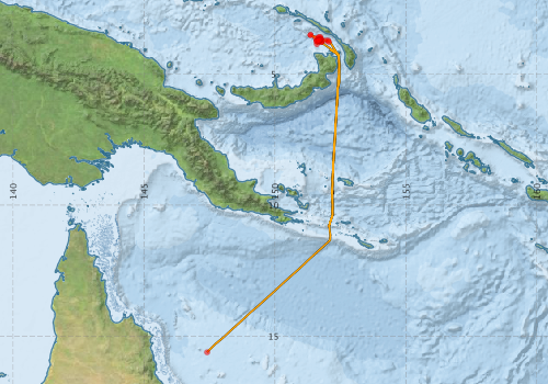
Voyage extents: 15° 36.8' S to 3° 30.4' S 147° 24.6' E to 152° 28.0' E Get voyage track shapefile Get CSV
Marlin Metadata:-
Participants - on ship:-
| Name | Role | Organisation |
|---|---|---|
| Alex Ortega-Osorio | Dept of Geology, Uni of Toronto | |
| Benny Kruman | Dept of Geology, Uni of PNG | |
| Bruce Gemmell | CODES, UTAS | |
| Dave Edwards | CSIRO Division of Oceanography | |
| Dave Vaudrey | Cruise Manager | CSIRO Division of Oceanography |
| Joanna Parr | CSIRO Exploration Geoscience | |
| John Eames | CSIRO Exploration Geoscience | |
| Keith Cook | HURL, University of Hawaii | |
| Larry Petrie | Dept of Geology, Uni of Toronto | |
| Ray Binns | Chief Investigator | CSIRO Exploration Geoscience |
| Roger Moss | Dept of Geology, Uni of Toronto | |
| Steve Scott | Dept of Geology, Uni of Toronto |
This list includes those that may have only been on part of the voyage. See voyage reports on 'Reports and Maps' tab for details.
Marine National Facility Reports - plans, summaries and data processing
-
FR199305 Voyage Summary
- includes preliminary results, voyage narrative, types of data collected with C77/ROSCOP codes.
-

Publications, reports and datasets from this voyage.
Journal Article
- Binns, R. A. (2014) Bikpela: A Large Siliceous Chimney from the PACMANUS Hydrothermal Field, Manus Basin, Papua New Guinea. Economic Geology 109 pp2243-2259. 10.2113/econgeo.109.8.2243
- Hu, Si-Yu,Barnes, Stephen J.,Pagès, Anaïs,Parr, Joanna,Binns, Ray,Verrall, Michael,Quadir, Zakaria,Rickard, William D.A.,Liu, Weihua,Fougerouse, Denis,Grice, Kliti,Schoneveld, Louise,Ryan, Chris,Paterson, David (2020) Life on the edge: Microbial biomineralization in an arsenic- and lead-rich deep-sea hydrothermal vent. Chemical Geology 533 pp119438-. 10.1016/j.chemgeo.2019.119438
- Jenner, F. E.,O'neill, H. S. C.,Arculus, R. J.,Mavrogenes, J. A. (2012) The Magnetite Crisis in the Evolution of Arc-related Magmas and the Initial Concentration of Au, Ag and Cu. Journal of Petrology 53 pp1089-1089. 10.1093/petrology/egs015
- Kamenetsky, V.S,Binns, R.A,Gemmell, J.B,Crawford, A.J,Mernagh, T.P,Maas, R,Steele, D (2001) Parental basaltic melts and fluids in eastern Manus backarc Basin: implications for hydrothermal mineralisation. Earth and Planetary Science Letters 184 pp685-702. 10.1016/s0012-821x%2800%2900352-6
- Kendrick, Mark A.,Danyushevsky, Leonid V.,Falloon, Trevor J.,Woodhead, Jon D.,Arculus, Richard J.,Ireland, Trevor (2020) SW Pacific arc and backarc lavas and the role of slab-bend serpentinites in the global halogen cycle. Earth and Planetary Science Letters 530 pp115921-. 10.1016/j.epsl.2019.115921
- Park, Jung-Woo,Campbell, Ian H.,Arculus, Richard J. (2013) Platinum-alloy and sulfur saturation in an arc-related basalt to rhyolite suite: Evidence from the Pual Ridge lavas, the Eastern Manus Basin. Geochimica et Cosmochimica Acta 101 pp76-95. 10.1016/j.gca.2012.10.001
- Yeats, C. J.,Parr, J. M.,Binns, R. A.,Gemmell, J. B.,Scott, S. D. (2014) The SuSu Knolls Hydrothermal Field, Eastern Manus Basin, Papua New Guinea: An Active Submarine High-Sulfidation Copper-Gold System. Economic Geology 109 pp2207-2226. 10.2113/econgeo.109.8.2207
Search for publications, reports and datasets from this and other voyages
Data publishing
This is a list of online datasets hosted by CSIRO. Other processed datasets hosted by collaborating organisations may be found on the 'Metadata' or "Reports, Publications and Maps' tab.
Use the Get data link on the right to extract data using the NCMI Data Trawler.
| Data Stream | Data Summary | Get data | ||||||||||||
|---|---|---|---|---|---|---|---|---|---|---|---|---|---|---|
| CTD profile | No data | |||||||||||||
| Underway |
|
Get Data from Trawler |
Deployments by start time:- Click on column header to sort. Use link on 'Deployment' to see full details. Use the CSV button at the bottom to export data (tab delimited).
Search for deployments from this voyage and others
| Deployment | Operation | Station | Cast | Gear | Project | Start and end times | Start Location | End Location | Depth range | Max Depth | Description | |||
|---|---|---|---|---|---|---|---|---|---|---|---|---|---|---|
| Underway System [details] | Simrad EA500 Echosounder | 133 | 1993-06-03 00:00 | 1993-06-23 23:55 | -15.6125 | 147.4100 | -10.8422 | 152.0740 | ||||||
| Sediment Sampling [details] | MD-24 | 133 | 1993-06-08 09:20 | -3.7267 | 151.6730 | |||||||||
| Sediment Sampling [details] | MD-25 | 133 | 1993-06-08 19:55 | |||||||||||
| Sediment Sampling [details] | MS-9 | 133 | 1993-06-09 00:10 | -3.7262 | 151.7097 | 2125 | ||||||||
| Sediment Sampling [details] | MS-10 | 133 | 1993-06-09 07:26 | -3.7497 | 151.6822 | 2110 | ||||||||
| Sediment Sampling [details] | MD-26 | 133 | 1993-06-09 09:30 | -3.7077 | 151.6563 | 2120 | ||||||||
| Sediment Sampling [details] | MS-11 | 133 | 1993-06-09 12:57 | -3.7292 | 151.5998 | 2389 | ||||||||
| Sediment Sampling [details] | MS-12 | 133 | 1993-06-09 14:36 | -3.7303 | 151.6000 | 2386 | ||||||||
| Sediment Sampling [details] | MD-27 | 133 | 1993-06-10 14:41 | -3.7305 | 151.6672 | 1670 | ||||||||
| Sediment Sampling [details] | MD-28 | 133 | 1993-06-10 17:01 | -3.7250 | 151.6730 | 1689 | ||||||||
| Sediment Sampling [details] | MS-13 | 133 | 1993-06-11 07:36 | -3.6800 | 151.7280 | 1904 | ||||||||
| Sediment Sampling [details] | MS-14 | 133 | 1993-06-11 20:28 | -3.6767 | 151.7645 | 2150 | ||||||||
| Sediment Sampling [details] | MS-15 | 133 | 1993-06-11 22:15 | -3.6343 | 151.7528 | |||||||||
| Sediment Sampling [details] | MD-29 | 133 | 1993-06-12 07:03 | -3.6905 | 151.7037 | 1827 | ||||||||
| Sediment Sampling [details] | MG-1 | 133 | 1993-06-12 09:56 | -3.7608 | 151.6702 | |||||||||
| Sediment Sampling [details] | MG-2 | 133 | 1993-06-12 10:57 | -3.7263 | 151.6707 | 1668 | ||||||||
| Sediment Sampling [details] | MD-30 | 133 | 1993-06-12 13:30 | -3.7205 | 151.6790 | 1702 | ||||||||
| Sediment Sampling [details] | MS-16 | 133 | 1993-06-12 20:45 | -3.6908 | 151.7560 | 2200 | ||||||||
| Sediment Sampling [details] | MS-17 | 133 | 1993-06-13 04:50 | -3.7705 | 151.7820 | 2170 | ||||||||
| Sediment Sampling [details] | MD-31 | 133 | 1993-06-13 06:02 | -3.7793 | 151.7573 | 2171 | ||||||||
| Sediment Sampling [details] | MD-32 | 133 | 1993-06-13 09:06 | -3.7513 | 151.7797 | 2065 | ||||||||
| Sediment Sampling [details] | MG-3 | 133 | 1993-06-13 12:18 | -3.7208 | 151.6725 | 1687 | ||||||||
| Sediment Sampling [details] | MG-4 | 133 | 1993-06-13 14:20 | -3.7218 | 151.6730 | 1680 | ||||||||
| Sediment Sampling [details] | MD-33 | 133 | 1993-06-13 20:04 | -3.5070 | 151.3530 | 2572 | ||||||||
| Sediment Sampling [details] | MD-34 | 133 | 1993-06-13 23:25 | -3.5120 | 151.3607 | 2569 | ||||||||
| Sediment Sampling [details] | MS-18 | 133 | 1993-06-14 04:26 | -3.6322 | 151.5582 | 2600 | ||||||||
| Sediment Sampling [details] | MS-19 | 133 | 1993-06-14 06:34 | -3.6442 | 151.6500 | 2485 | ||||||||
| Sediment Sampling [details] | MG-5 | 133 | 1993-06-15 01:31 | -3.7253 | 151.6683 | 1658 | ||||||||
| Sediment Sampling [details] | MG-6 | 133 | 1993-06-15 02:44 | -3.7285 | 151.6693 | 1646 | ||||||||
| Sediment Sampling [details] | MG-7 | 133 | 1993-06-15 15:19 | -3.7288 | 151.6710 | 1660 | ||||||||
| Sediment Sampling [details] | MD-35 | 133 | 1993-06-15 16:20 | -3.7233 | 151.6755 | 1700 | ||||||||
| Sediment Sampling [details] | MD-36 | 133 | 1993-06-15 22:53 | -3.7102 | 151.7083 | 1811 | ||||||||
| Sediment Sampling [details] | MS-20 | 133 | 1993-06-16 03:27 | -3.7095 | 151.7300 | |||||||||
| Sediment Sampling [details] | MD-37 | 133 | 1993-06-16 04:56 | -3.5852 | 151.7238 | 1981 | ||||||||
| Sediment Sampling [details] | MD-38 | 133 | 1993-06-16 07:40 | -3.5927 | 151.6758 | 2265 | ||||||||
| Sediment Sampling [details] | MD-39 | 133 | 1993-06-16 21:30 | -3.6712 | 151.7422 | 1878 | ||||||||
| Sediment Sampling [details] | MG-8 | 133 | 1993-06-17 01:36 | -3.7027 | 151.7085 | 1865 | ||||||||
| Sediment Sampling [details] | MG-9 | 133 | 1993-06-17 02:43 | -3.7033 | 151.7092 | 1868 | ||||||||
| Sediment Sampling [details] | MG-10 | 133 | 1993-06-17 04:09 | -3.7005 | 151.6750 | 1948 | ||||||||
| Sediment Sampling [details] | MG-11 | 133 | 1993-06-17 06:39 | -3.7157 | 151.6858 | 1660 | ||||||||
| Sediment Sampling [details] | MG-12 | 133 | 1993-06-17 07:54 | -3.6868 | 151.6972 | 1872 | ||||||||
| Sediment Sampling [details] | MD-40 | 133 | 1993-06-17 10:35 | -3.8600 | 151.5993 | 2067 | ||||||||
| Sediment Sampling [details] | MD-41 | 133 | 1993-06-17 18:39 | -3.7243 | 151.6752 | 1696 | ||||||||
| Sediment Sampling [details] | MS-21 | 133 | 1993-06-18 00:00 | |||||||||||
| Sediment Sampling [details] | MD-42 | 133 | 1993-06-18 02:43 | -3.7543 | 151.5833 | 2381 | ||||||||
| Sediment Sampling [details] | MG-13 | 133 | 1993-06-18 10:59 | -3.7123 | 151.6548 | 2203 | ||||||||
| Sediment Sampling [details] | MD-43 | 133 | 1993-06-18 19:37 | -3.7212 | 151.9367 | 2160 | ||||||||
| Sediment Sampling [details] | MD-44 | 133 | 1993-06-19 00:05 | -3.7238 | 152.0312 | 2085 | ||||||||
| Sediment Sampling [details] | MD-45 | 133 | 1993-06-19 12:59 | -3.7705 | 152.0600 | 1692 | ||||||||