Voyage details and related metadata, reports, events and data.
FR 06/92
(alternative identifier: FR199206)
- is a Marine National Facility ![]() voyage
voyage
Period: 1992-07-15 00:00 to 1992-08-13 00:00 Local
Duration: 29.00 days
From: Lae To: Townsville
Region: Equatorial West Pacific Ocean/New Guinea coast
Ship: Franklin [details]
Description: Cruise FR 06/92 forms part of the TOGA-COARE study. The joint Australia-Japan moored intrument array commenced in November 1989 and involves maintaining a current meter mooring on the equator at 147 degrees E. The mooring is part of the TOGA (Tropical Ocean Global Atmosphere) moored observing array for observing currents in the equatorial Pacific Ocean. This cruise was the sixth cycle, marking the end of the CSIRO involvement in the field phase of operation and the end of the third Tokai University surface mooring deployment. The moored current meter array in the New Guinea coastal undercurrent is to directly measure the currents in and transport through Vitiaz Strait, PNG, over an annual cycle. A line of five moorings were deployed across the strait from RV Moana Wave in Frebruary 1992 and the primary task of this cruise was to recover, service and redeploy the moorings, and to collect CTD and ADCP data for use in later interpretation of the moored data. Related cruises are FR 06/91 and FR 07/90.
Leader: E. Lindstrom (CSIRO), including other Pis
Project: Climate Variability 1989-1997 [details]
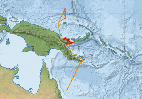
Voyage extents: 16° 58.1' S to 1° 00.0' N 145° 34.6' E to 150° 58.7' E Get voyage track shapefile Get CSV
Marlin Metadata:-
Participants - on ship:-
| Name | Role | Organisation |
|---|---|---|
| Dan McLaughlan | CSIRO Division of Oceanography | |
| Eric Lindstrom | Chief Investigator | Texas A&M University |
| Floyd DeMers | Louisiana State University | |
| Hideo Inaba | Tokai University | |
| Hiroshi Moriya | Tokai University | |
| Jan Petersen | CSIRO Division of Oceanography | |
| Jeff Butt | Cruise Manager | CSIRO Division of Oceanography |
| Masaki Lida | Tokai University | |
| Phil Adams | CSIRO Division of Oceanography | |
| Rodney Fredericks | Louisiana State University | |
| Ron Plaschke | CSIRO Division of Oceanography | |
| Stephen Murray | Louisiana State University | |
| Steve Dartez | Louisiana State University | |
| Walker Winans | Louisiana State University |
This list includes those that may have only been on part of the voyage. See voyage reports on 'Reports and Maps' tab for details.
Marine National Facility Reports - plans, summaries and data processing
-
FR199206 Voyage Summary
- includes preliminary results, voyage narrative, types of data collected with C77/ROSCOP codes.
-

Search for publications, reports and datasets from this and other voyages
Data publishing
This is a list of online datasets hosted by CSIRO. Other processed datasets hosted by collaborating organisations may be found on the 'Metadata' or "Reports, Publications and Maps' tab.
Use the Get data link on the right to extract data using the NCMI Data Trawler.
| Data Stream | Data Summary | Get data | ||||||||||||||
|---|---|---|---|---|---|---|---|---|---|---|---|---|---|---|---|---|
| ADCP Data |
|
Get Data from Trawler Download ASCII dataset - fr9206adcp.zip Download NetCDF dataset - fr9206adcpCDF.zip |
||||||||||||||
| CTD profile |
|
Get Data from Trawler Processing report for this dataset |
||||||||||||||
| Hydrology |
|
Get Data from Trawler |
||||||||||||||
| Underway |
|
Get Data from Trawler |
Deployments by start time:- Click on column header to sort. Use link on 'Deployment' to see full details. Use the CSV button at the bottom to export data (tab delimited).
Search for deployments from this voyage and others
| Deployment | Operation | Station | Cast | Gear | Project | Start and end times | Start Location | End Location | Depth range | Max Depth | Description | |||
|---|---|---|---|---|---|---|---|---|---|---|---|---|---|---|
| Underway System [details] | Anemometer,Anemometer,Anemometer,Gyro-MK 10,Humidity probe,Licor-UWQ 4653,RIMCO vane driving potentiometer,RIMCO vane driving potentiometer,Ships log,Simrad EA500 Echosounder,Temperature sensor-AD590J,ThermoSalinoGraph (TSG),ThermoSalinoGraph (TSG) | 1532 | 1992-07-14 00:00 | 1992-08-04 23:55 | -6.7912 | 147.2950 | -16.9685 | 147.3410 | ||||||
| ADCP Data [details] | RDI VM-150 Acoustic Doppler current profiler | 1532 | 1992-07-14 02:40 | 1992-08-03 08:40 | -6.8040 | 147.4330 | -16.9040 | 147.3730 | 424.8 | |||||
| CTD Cast / Hydrology [details] | 1 | Cast 1 | 1532 | 1992-07-14 08:14 | 1992-07-14 09:38 | -6.4355 | 148.3982 | -6.4185 | 148.3858 | 0 | ||||
| CTD Cast / Hydrology [details] | 1 | Cast 2 | 1532 | 1992-07-14 11:51 | 1992-07-14 12:50 | -6.1963 | 147.9807 | -6.1765 | 147.9738 | 0 | ||||
| CTD Cast / Hydrology [details] | 1 | Cast 3 | 1532 | 1992-07-16 09:00 | 1992-07-16 09:38 | -5.9780 | 147.5313 | -5.9508 | 147.5133 | 0 | ||||
| CTD Cast / Hydrology [details] | 1 | Cast 4 | 1532 | 1992-07-16 10:18 | 1992-07-16 10:55 | -5.9445 | 147.5718 | -5.9215 | 147.5555 | 0 | ||||
| CTD Cast / Hydrology [details] | 1 | Cast 5 | 1532 | 1992-07-16 11:39 | 1992-07-17 00:00 | -5.9140 | 147.6113 | -5.9787 | 147.8857 | 0 | ||||
| CTD Cast / Hydrology [details] | 1 | Cast 7 | 1532 | 1992-07-16 13:29 | 1992-07-16 14:27 | -5.8807 | 147.6515 | -5.8515 | 147.6370 | 0 | ||||
| CTD Cast / Hydrology [details] | 1 | Cast 8 | 1532 | 1992-07-16 15:24 | 1992-07-16 16:22 | -5.8503 | 147.6968 | -5.8222 | 147.6792 | 0 | ||||
| CTD Cast / Hydrology [details] | 1 | Cast 9 | 1532 | 1992-07-16 17:24 | 1992-07-16 18:17 | -5.8135 | 147.7307 | -5.7955 | 147.7242 | 0 | ||||
| CTD Cast / Hydrology [details] | 1 | Cast 10 | 1532 | 1992-07-17 07:40 | 1992-07-17 08:07 | -5.4030 | 147.0105 | -5.3897 | 147.0020 | 0 | ||||
| CTD Cast / Hydrology [details] | 1 | Cast 11 | 1532 | 1992-07-17 09:06 | 1992-07-17 10:13 | -5.4467 | 146.9640 | -5.4090 | 146.9357 | 0 | ||||
| CTD Cast / Hydrology [details] | 1 | Cast 12 | 1532 | 1992-07-17 11:01 | 1992-07-17 12:13 | -5.4897 | 146.9205 | -5.4558 | 146.8927 | 0 | ||||
| CTD Cast / Hydrology [details] | 1 | Cast 13 | 1532 | 1992-07-17 12:57 | 1992-07-17 13:38 | -5.5390 | 146.8747 | -5.5333 | 146.8597 | 0 | ||||
| CTD Cast / Hydrology [details] | 1 | Cast 14 | 1532 | 1992-07-17 14:45 | 1992-07-17 15:48 | -5.5863 | 146.8225 | -5.5713 | 146.8053 | 0 | ||||
| CTD Cast / Hydrology [details] | 1 | Cast 15 | 1532 | 1992-07-17 16:24 | 1992-07-17 17:24 | -5.6327 | 146.7865 | -5.6243 | 146.7750 | 0 | ||||
| CTD Cast / Hydrology [details] | 1 | Cast 16 | 1532 | 1992-07-17 17:55 | 1992-07-17 18:56 | -5.6765 | 146.7432 | -5.6720 | 146.7537 | 0 | ||||
| CTD Cast / Hydrology [details] | 1 | Cast 17 | 1532 | 1992-07-19 10:44 | 1992-07-19 11:30 | -1.0010 | 147.0012 | -1.0017 | 147.0038 | 0 | ||||
| CTD Cast / Hydrology [details] | 1 | Cast 18 | 1532 | 1992-07-19 14:23 | 1992-07-19 15:10 | -0.4997 | 147.0010 | -0.5008 | 147.0020 | 0 | ||||
| CTD Cast / Hydrology [details] | 1 | Cast 19 | 1532 | 1992-07-19 20:20 | 1992-07-19 21:09 | -0.0005 | 147.0342 | -0.0020 | 147.0333 | 0 | ||||
| CTD Cast / Hydrology [details] | 1 | Cast 20 | 1532 | 1992-07-20 04:12 | 1992-07-20 04:59 | 0.5018 | 147.0000 | 0.5015 | 147.0107 | 0 | ||||
| CTD Cast / Hydrology [details] | 1 | Cast 21 | 1532 | 1992-07-20 07:37 | 1992-07-20 08:24 | 0.9992 | 146.9995 | 1.0005 | 147.0092 | 0 | ||||
| CTD Cast / Hydrology [details] | 1 | Cast 22 | 1532 | 1992-07-23 10:28 | 1992-07-23 11:14 | -5.7260 | 146.7025 | -5.7242 | 146.6987 | 0 | ||||
| CTD Cast / Hydrology [details] | 1 | Cast 23 | 1532 | 1992-07-23 13:56 | 1992-07-23 15:02 | -5.4502 | 146.9607 | -5.4355 | 146.9305 | 0 | ||||
| CTD Cast / Hydrology [details] | 1 | Cast 24 | 1532 | 1992-07-25 03:55 | 1992-07-25 04:30 | -5.9742 | 147.5278 | -5.9557 | 147.5113 | 0 | ||||
| CTD Cast / Hydrology [details] | 1 | Cast 25 | 1532 | 1992-07-25 05:21 | 1992-07-25 05:57 | -5.9472 | 147.5745 | -5.9315 | 147.5608 | 0 | ||||
| CTD Cast / Hydrology [details] | 1 | Cast 26 | 1532 | 1992-07-25 06:42 | 1992-07-25 07:28 | -5.9135 | 147.6088 | -5.8888 | 147.5942 | 0 | ||||
| CTD Cast / Hydrology [details] | 1 | Cast 27 | 1532 | 1992-07-25 08:23 | 1992-07-25 09:18 | -5.8855 | 147.6548 | -5.8582 | 147.6360 | 0 | ||||
| CTD Cast / Hydrology [details] | 1 | Cast 28 | 1532 | 1992-07-25 10:10 | 1992-07-25 11:10 | -5.8520 | 147.6942 | -5.8078 | 147.6672 | 0 | ||||
| CTD Cast / Hydrology [details] | 1 | Cast 29 | 1532 | 1992-07-25 12:06 | 1992-07-25 12:58 | -5.8208 | 147.7350 | -5.7907 | 147.7220 | 0 | ||||
| CTD Cast / Hydrology [details] | 1 | Cast 30 | 1532 | 1992-07-25 13:34 | 1992-07-25 14:13 | -5.7935 | 147.7807 | -5.7852 | 147.7822 | 0 | ||||
| CTD Cast / Hydrology [details] | 1 | Cast 31 | 1532 | 1992-07-26 14:36 | 1992-07-26 15:44 | -5.6290 | 147.2268 | -5.5953 | 147.1980 | 0 | ||||
| CTD Cast / Hydrology [details] | 1 | Cast 32 | 1532 | 1992-07-26 17:36 | 1992-07-26 18:44 | -5.6295 | 147.3910 | -5.5988 | 147.3715 | 0 | ||||
| CTD Cast / Hydrology [details] | 1 | Cast 33 | 1532 | 1992-07-27 07:59 | 1992-07-27 09:00 | -5.7073 | 147.5497 | -5.6912 | 147.5293 | 0 | ||||
| CTD Cast / Hydrology [details] | 1 | Cast 34 | 1532 | 1992-07-27 12:12 | 1992-07-27 13:11 | -5.8125 | 147.6180 | -5.7820 | 147.6025 | 0 | ||||
| CTD Cast / Hydrology [details] | 1 | Cast 35 | 1532 | 1992-07-27 15:21 | 1992-07-27 16:14 | -5.9775 | 147.7247 | -5.9567 | 147.7068 | 0 | ||||
| CTD Cast / Hydrology [details] | 1 | Cast 36 | 1532 | 1992-07-27 17:56 | 1992-07-27 19:05 | -6.0848 | 147.8518 | -6.0622 | 147.8408 | 0 | ||||
| CTD Cast / Hydrology [details] | 1 | Cast 37 | 1532 | 1992-07-28 07:59 | 1992-07-28 09:07 | -6.1948 | 147.9823 | -6.1688 | 147.9793 | 0 | ||||
| CTD Cast / Hydrology [details] | 1 | Cast 38 | 1532 | 1992-07-28 10:31 | 1992-07-28 11:52 | -6.3090 | 148.1027 | -6.2898 | 148.0913 | 0 | ||||
| CTD Cast / Hydrology [details] | 1 | Cast 39 | 1532 | 1992-07-28 13:33 | 1992-07-28 14:53 | -6.3797 | 148.2528 | -6.3665 | 148.2428 | 0 | ||||
| CTD Cast / Hydrology [details] | 1 | Cast 40 | 1532 | 1992-07-28 17:43 | 1992-07-28 19:03 | -6.3673 | 148.6003 | -6.3605 | 148.5783 | 0 | ||||
| CTD Cast / Hydrology [details] | 1 | Cast 41 | 1532 | 1992-07-28 20:18 | 1992-07-28 21:41 | -6.3100 | 148.7252 | -6.2998 | 148.7087 | 0 | ||||
| CTD Cast / Hydrology [details] | 1 | Cast 42 | 1532 | 1992-07-28 22:53 | 1992-07-29 00:16 | -6.3273 | 148.8405 | -6.3235 | 148.8230 | 0 | ||||
| CTD Cast / Hydrology [details] | 1 | Cast 43 | 1532 | 1992-07-29 02:28 | 1992-07-29 03:46 | -6.4207 | 148.4742 | -6.4107 | 148.4605 | 0 | ||||
| CTD Cast / Hydrology [details] | 1 | Cast 44 | 1532 | 1992-07-29 04:27 | 1992-07-29 05:46 | -6.4732 | 148.3610 | -6.4627 | 148.3478 | 0 | ||||
| CTD Cast / Hydrology [details] | 1 | Cast 45 | 1532 | 1992-07-29 06:31 | 1992-07-29 07:50 | -6.5363 | 148.2353 | -6.5277 | 148.2262 | 0 | ||||
| CTD Cast / Hydrology [details] | 1 | Cast 46 | 1532 | 1992-07-29 08:33 | 1992-07-29 09:50 | -6.5988 | 148.1102 | -6.5895 | 148.0963 | 0 | ||||
| CTD Cast / Hydrology [details] | 1 | Cast 47 | 1532 | 1992-07-29 10:37 | 1992-07-29 11:37 | -6.6598 | 147.9853 | -6.6480 | 147.9685 | 0 | ||||