Voyage details and related metadata, reports, events and data.
FR 05/92
(alternative identifier: FR199205)
- is a Marine National Facility ![]() voyage
voyage
Period: 1992-06-15 00:00 to 1992-07-13 00:00 Local
Duration: 28.00 days
From: Townsville To: Lae
Region: Equatorial West Pacific Ocean
Ship: Franklin [details]
Description: FR 05/92 forms part of the JGOFS study - Inorganic and Organic Carbon Cycles in Equatorial Waters. The cruise track was west and north of Papua New Guinea, in the Solomon Sea and the western equatorial Pacific Ocean to 10 degrees N. Cruise objectives included profiles of pH, carbon dioxide and fluorescence, measurements of primary and secondary productivity, studies of vertical carbon fluxes, investigation of processes of biomass production, and pigment analyses of phytoplankton community structure. Samples collected for further laboratory study included those for zooplankton, lipids, pigments, bacteria, cyanobacteria, trace metals, copper complexing capacity, DIC and alkalinity. Related Franklin cruises are FR 08/90 and FR 08/93.
Leader: D. Mackey, J. Parslow (CSIRO)
Project: Global Carbon Cycle 1989-1993 [details]
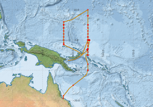
Voyage extents: 19° 15.0' S to 10° 00.6' N 146° 49.7' E to 155° 32.2' E Get voyage track shapefile Get CSV
Marlin Metadata:-
Metadata from OBIS Australia datasets:- biological data is published via the OBIS-AU IPT server and delivered to one or more of OBIS, ALA and GBIF
Download from OBIS Australia IPT View at - Ocean Biodiversity Information System (OBIS) Atlas of Living Australia (ALA) GBIF
Participants - on ship:-
| Name | Role | Organisation |
|---|---|---|
| Bob Beattie | Cruise Manager | CSIRO Division of Oceanography |
| Brian Griffiths | CSIRO Division of Oceanography | |
| Bronte Tilbrook | CSIRO Division of Oceanography | |
| Danny Holdsworth | CSIRO Division of Oceanography | |
| Dave Terhell | CSIRO Division of Oceanography | |
| Denis Mackey | Chief Investigator | CSIRO Division of Oceanography |
| Don McKenzie | CSIRO Division of Oceanography | |
| Erik Madsen | CSIRO Division of Oceanography | |
| Harry Higgins | CSIRO Division of Oceanography | |
| John Parslow | CSIRO Division of Fisheries | |
| John Volkman | CSIRO Division of Oceanography | |
| Mark Pretty | CSIRO Division of Oceanography | |
| Phil Adams | CSIRO Division of Oceanography | |
| Pru Bonham | CSIRO Division of Oceanography | |
| Ros Watson | CSIRO Division of Oceanography | |
| Teresa O'Leary | CSIRO Division of Oceanography | |
| Val Latham | CSIRO Division of Oceanography |
This list includes those that may have only been on part of the voyage. See voyage reports on 'Reports and Maps' tab for details.
Marine National Facility Reports - plans, summaries and data processing
-
FR199205 Voyage Summary
- includes preliminary results, voyage narrative, types of data collected with C77/ROSCOP codes.
-
FR199205 Voyage Plan
- includes objectives, investigator details, proposed data collection, voyage track and equipment to be used.
-

Publications, reports and datasets from this voyage.
Dataset
- Bouman, Heather A; Platt, Trevor; Doblin, Martina A; Figueiras, Francisco G; Gudmundsson, Kristinn; Gudfinnsson, Hafsteinn G; Huang, Bangqin; Hickman, Anna; Hiscock, Michael R; Jackson, Thomas; Lutz, Vivian A; Melin, Frederic; Rey, Francisco; Pepin, Pierre; Segura, Valeria; Tilstone, Gavin; van Dongen-Vogels, Virginie; Sathyendranath, Shubha (2017): A global dataset of photosynthesis-irradiance parameters for marine phytoplankton. PANGAEA, 10.1594/PANGAEA.874087
- Griffiths, Brian (2003): Primary production modelling from FRANKLIN cruise FR05/92 of CSIRO. PANGAEA, 10.1594/PANGAEA.104843
- Griffiths, Brian (2003): Zooplankton biomass during FRANKLIN cruise FR05/92. PANGAEA, 10.1594/PANGAEA.104848
- Higgins, Harry (2013): Bacteria abundances measured on water bottle samples during FRANKLIN cruise FR05/92. PANGAEA 10.1594/PANGAEA.808090
- Higgins, Harry (2013): Cyanobacteria abundances measured on water bottle samples during FRANKLIN cruise FR05/92. PANGAEA 10.1594/PANGAEA.808095
IPT Resource
- Seabird observations in Australian and adjacent seas from voyages of the RV Franklin, RV Southern Surveyor, Southern Supporter and RV Aurora Australis (1988-2012) (Darwin Core Archive) External link to reference
Journal Article
- Cheshire, N. (2010) Procellariiformes observed around Papua New Guinea including the Bismarck Archipelago from 1985 to 2007. South Australian Ornithologist Vol 36, parts 1 &2 (p. 9-24)
- Higgins, H.W,Mackey, D.J (2000) Algal class abundances, estimated from chlorophyll and carotenoid pigments, in the western Equatorial Pacific under El Niño and non-El Niño conditions. Deep Sea Research Part I: Oceanographic Research Papers 47 pp1461-1483. 10.1016/S0967-0637(99)00114-4
- Mackey, D.J.,Parslow, J.S.,Griffiths, F.B.,Higgins, H.W.,Tilbrook, B. (1997) Phytoplankton productivity and the carbon cycle in the western Equatorial Pacific under El Nin˜o and non-El Nin˜o conditions. Deep Sea Research Part II: Topical Studies in Oceanography 44 pp1951-1978. 10.1016/s0967-0645%2897%2900033-7
Search for publications, reports and datasets from this and other voyages
Data publishing
This is a list of online datasets hosted by CSIRO. Other processed datasets hosted by collaborating organisations may be found on the 'Metadata' or "Reports, Publications and Maps' tab.
Use the Get data link on the right to extract data using the NCMI Data Trawler.
| Data Stream | Data Summary | Get data | ||||||||||||||
|---|---|---|---|---|---|---|---|---|---|---|---|---|---|---|---|---|
| ADCP Data |
|
Get Data from Trawler Download ASCII dataset - fr9205adcp.zip Download NetCDF dataset - fr9205adcpCDF.zip |
||||||||||||||
| Marine biodiversity observations and/or samples |
|
Get Data from Trawler |
||||||||||||||
| CTD profile |
|
Get Data from Trawler |
||||||||||||||
| Hydrology |
|
Get Data from Trawler |
||||||||||||||
| Underway |
|
Get Data from Trawler |
Deployments by start time:- Click on column header to sort. Use link on 'Deployment' to see full details. Use the CSV button at the bottom to export data (tab delimited).
Search for deployments from this voyage and others
| Deployment | Operation | Station | Cast | Gear | Project | Start and end times | Start Location | End Location | Depth range | Max Depth | Description | |||
|---|---|---|---|---|---|---|---|---|---|---|---|---|---|---|
| Underway System [details] | Anemometer,Anemometer,Anemometer,Gyro-MK 10,Humidity probe,Licor-UWQ 4653,RIMCO vane driving potentiometer,RIMCO vane driving potentiometer,Ships log,Simrad EA500 Echosounder,Temperature sensor-AD590J,ThermoSalinoGraph (TSG),ThermoSalinoGraph (TSG) | 1540 | 1992-06-15 00:00 | 1992-07-13 23:55 | -19.2507 | 146.8350 | -6.7792 | 148.3870 | ||||||
| ADCP Data [details] | RDI VM-150 Acoustic Doppler current profiler | 1540 | 1992-06-16 10:00 | 1992-07-12 13:20 | -18.4640 | 146.9150 | -6.7680 | 148.4620 | 408.8 | |||||
| CTD Cast / Hydrology [details] | 1 | Cast 1 | 1540 | 1992-06-17 09:13 | 1992-06-17 09:44 | -14.9992 | 150.1308 | -14.9937 | 150.1297 | 0 | ||||
| CTD Cast / Hydrology [details] | 1 | Cast 2 | 1540 | 1992-06-18 19:54 | 1992-06-18 21:16 | -9.9975 | 154.9973 | -9.9875 | 154.9913 | 0 | ||||
| CTD Cast [details] | 1 | Cast 3 | 1540 | 1992-06-18 22:25 | 1992-06-18 22:39 | -10.0018 | 154.9982 | -9.9998 | 154.9950 | 0 | ||||
| CTD Cast / Hydrology [details] | 1 | Cast 4 | 1540 | 1992-06-19 08:32 | 1992-06-19 09:56 | -8.0015 | 155.0005 | -7.9982 | 154.9978 | 0 | ||||
| CTD Cast [details] | 1 | Cast 5 | 1540 | 1992-06-20 06:07 | 1992-06-20 06:14 | -5.0037 | 155.0002 | -5.0043 | 155.0002 | 0 | ||||
| CTD Cast / Hydrology [details] | 1 | Cast 6 | 1540 | 1992-06-20 06:30 | 1992-06-20 08:04 | -5.0028 | 155.0012 | -4.9958 | 155.0138 | 0 | ||||
| CTD Cast [details] | 1 | Cast 7 | 1540 | 1992-06-20 10:16 | 1992-06-20 12:42 | -4.9995 | 154.9982 | -5.0000 | 155.0012 | 0 | ||||
| CTD Cast / Hydrology [details] | 1 | Cast 8 | 1540 | 1992-06-20 17:48 | 1992-06-20 19:09 | -4.0013 | 155.0015 | -3.9982 | 155.0047 | 0 | ||||
| CTD Cast [details] | 1 | Cast 9 | 1540 | 1992-06-21 00:22 | 1992-06-21 00:30 | -3.0005 | 155.0023 | -3.0007 | 155.0032 | 0 | ||||
| CTD Cast / Hydrology [details] | 1 | Cast 10 | 1540 | 1992-06-21 00:39 | 1992-06-21 02:06 | -2.9990 | 155.0033 | -2.9918 | 155.0107 | 0 | ||||
| CTD Cast / Hydrology [details] | 1 | Cast 11 | 1540 | 1992-06-21 07:13 | 1992-06-21 08:36 | -1.9982 | 155.0005 | -1.9950 | 155.0122 | 0 | ||||
| CTD Cast / Hydrology [details] | 1 | Cast 12 | 1540 | 1992-06-21 13:25 | 1992-06-21 14:50 | -0.9965 | 155.0005 | -0.9888 | 155.0118 | 0 | ||||
| CTD Cast [details] | 1 | Cast 13 | 1540 | 1992-06-21 19:42 | 1992-06-21 21:31 | 0.0033 | 155.0012 | 0.0108 | 155.0203 | 0 | ||||
| CTD Cast / Hydrology [details] | 1 | Cast 14 | 1540 | 1992-06-21 22:30 | 1992-06-21 23:51 | 0.0005 | 155.0015 | 0.0093 | 155.0122 | 0 | ||||
| CTD Cast [details] | 1 | Cast 15 | 1540 | 1992-06-22 00:49 | 1992-06-22 01:05 | 0.0025 | 155.0017 | 0.0042 | 155.0037 | 0 | ||||
| CTD Cast [details] | 1 | Cast 16 | 1540 | 1992-06-22 05:39 | 1992-06-22 05:47 | 1.0027 | 155.0015 | 1.0033 | 155.0038 | 0 | ||||
| CTD Cast / Hydrology [details] | 1 | Cast 17 | 1540 | 1992-06-22 05:55 | 1992-06-22 07:11 | 1.0058 | 155.0048 | 1.0108 | 155.0237 | 0 | ||||
| CTD Cast / Hydrology [details] | 1 | Cast 18 | 1540 | 1992-06-22 11:56 | 1992-06-22 13:26 | 2.0023 | 155.0028 | 2.0123 | 155.0312 | 0 | ||||
| CTD Cast / Hydrology [details] | 1 | Cast 19 | 1540 | 1992-06-22 18:17 | 1992-06-22 19:48 | 2.9907 | 155.0008 | 3.0053 | 155.0150 | 0 | ||||
| CTD Cast / Hydrology [details] | 1 | Cast 20 | 1540 | 1992-06-23 01:00 | 1992-06-23 02:22 | 4.0010 | 155.0008 | 4.0122 | 155.0118 | 0 | ||||
| CTD Cast / Hydrology [details] | 1 | Cast 21 | 1540 | 1992-06-23 07:29 | 1992-06-23 08:52 | 5.0022 | 155.0045 | 5.0152 | 155.0077 | 0 | ||||
| CTD Cast [details] | 1 | Cast 22 | 1540 | 1992-06-23 09:53 | 1992-06-23 11:53 | 5.0007 | 154.9998 | 5.0115 | 154.9988 | 0 | ||||
| CTD Cast / Hydrology [details] | 1 | Cast 23 | 1540 | 1992-06-24 02:43 | 1992-06-24 04:06 | 7.9988 | 154.9983 | 7.9963 | 154.9967 | 0 | ||||
| CTD Cast [details] | 1 | Cast 24 | 1540 | 1992-06-24 05:04 | 1992-06-24 05:20 | 8.0013 | 154.9993 | 8.0007 | 154.9973 | 0 | ||||
| CTD Cast / Hydrology [details] | 1 | Cast 25 | 1540 | 1992-06-24 15:34 | 1992-06-24 17:10 | 9.9992 | 154.9988 | 10.0118 | 154.9855 | 0 | ||||
| CTD Cast / Hydrology [details] | 1 | Cast 26 | 1540 | 1992-06-26 13:32 | 1992-06-26 15:02 | 6.0008 | 146.9998 | 6.0173 | 146.9950 | 0 | ||||
| CTD Cast / Hydrology [details] | 1 | Cast 27 | 1540 | 1992-06-26 20:27 | 1992-06-26 21:48 | 5.0012 | 147.0020 | 5.0117 | 146.9893 | 0 | ||||
| CTD Cast [details] | 1 | Cast 28 | 1540 | 1992-06-26 22:02 | 1992-06-26 22:10 | 5.0130 | 146.9867 | 5.0127 | 146.9850 | 0 | ||||
| CTD Cast [details] | 1 | Cast 29 | 1540 | 1992-06-26 22:12 | 1992-06-26 22:19 | 5.0127 | 146.9845 | 5.0128 | 146.9828 | 0 | ||||
| CTD Cast [details] | 1 | Cast 30 | 1540 | 1992-06-27 03:59 | 1992-06-27 04:08 | 3.9992 | 146.9973 | 0 | ||||||
| CTD Cast / Hydrology [details] | 1 | Cast 31 | 1540 | 1992-06-27 04:15 | 1992-06-27 05:32 | 3.9992 | 146.9990 | 4.0013 | 147.0015 | 0 | ||||
| CTD Cast / Hydrology [details] | 1 | Cast 32 | 1540 | 1992-06-27 10:52 | 1992-06-27 12:21 | 2.9985 | 147.0008 | 3.0013 | 147.0165 | 0 | ||||
| CTD Cast / Hydrology [details] | 1 | Cast 33 | 1540 | 1992-06-27 17:33 | 1992-06-27 18:55 | 1.9980 | 147.0007 | 1.9927 | 147.0183 | 0 | ||||
| CTD Cast / Hydrology [details] | 1 | Cast 34 | 1540 | 1992-06-28 00:03 | 1992-06-28 01:25 | 0.9992 | 147.0017 | 1.0055 | 147.0133 | 0 | ||||
| CTD Cast / Hydrology [details] | 1 | Cast 35 | 1540 | 1992-06-28 08:03 | 1992-06-28 09:26 | -0.0017 | 147.0018 | 0.0077 | 147.0188 | 0 | ||||
| CTD Cast / Hydrology [details] | 1 | Cast 36 | 1540 | 1992-06-28 15:00 | 1992-06-28 16:27 | -1.0030 | 147.0018 | -1.0068 | 147.0092 | 0 | ||||
| CTD Cast / Hydrology [details] | 1 | Cast 37 | 1540 | 1992-06-28 20:26 | 1992-06-28 21:35 | -1.5007 | 147.0017 | -1.5020 | 147.0093 | 0 | ||||
| CTD Cast [details] | 1 | Cast 38 | 1540 | 1992-06-28 21:53 | 1992-06-28 22:01 | -1.5045 | 147.0153 | -1.5055 | 147.0178 | 0 | ||||
| CTD Cast / Hydrology [details] | 1 | Cast 39 | 1540 | 1992-07-03 08:11 | 1992-07-03 09:55 | 0.0052 | 155.0085 | 0.0162 | 155.0173 | 0 | ||||
| CTD Cast / Hydrology [details] | 1 | Cast 40 | 1540 | 1992-07-03 16:06 | 1992-07-03 16:43 | 0.0178 | 155.0823 | 0.0193 | 155.0945 | 0 | ||||
| CTD Cast / Hydrology [details] | 1 | Cast 41 | 1540 | 1992-07-03 21:54 | 1992-07-03 22:26 | 0.0043 | 155.1205 | 0.0113 | 155.1282 | 0 | ||||
| CTD Cast / Hydrology [details] | 1 | Cast 42 | 1540 | 1992-07-04 04:13 | 1992-07-04 04:39 | -0.0003 | 155.1605 | -0.0012 | 155.1690 | 0 | ||||
| CTD Cast / Hydrology [details] | 1 | Cast 43 | 1540 | 1992-07-04 10:02 | 1992-07-04 10:24 | 0.0008 | 155.2118 | 0.0063 | 155.2158 | 0 | ||||
| CTD Cast / Hydrology [details] | 1 | Cast 44 | 1540 | 1992-07-04 15:53 | 1992-07-04 16:32 | -0.0145 | 155.2560 | -0.0138 | 155.2695 | 0 | ||||
| CTD Cast [details] | 1 | Cast 45 | 1540 | 1992-07-04 18:25 | 1992-07-04 18:44 | -0.0222 | 155.2757 | -0.0202 | 155.2822 | 0 | ||||
| CTD Cast / Hydrology [details] | 1 | Cast 46 | 1540 | 1992-07-04 21:58 | 1992-07-04 22:31 | -0.0247 | 155.2992 | -0.0187 | 155.3033 | 0 | ||||
| CTD Cast / Hydrology [details] | 1 | Cast 47 | 1540 | 1992-07-05 04:02 | 1992-07-05 04:34 | -0.0275 | 155.3482 | -0.0292 | 155.3585 | 0 | ||||
| CTD Cast / Hydrology [details] | 1 | Cast 48 | 1540 | 1992-07-05 10:01 | 1992-07-05 10:25 | -0.0425 | 155.3873 | -0.0465 | 155.3917 | 0 | ||||
| CTD Cast [details] | 1 | Cast 49 | 1540 | 1992-07-05 15:37 | 1992-07-05 15:59 | -0.0508 | 155.4125 | -0.0518 | 155.4200 | 0 | ||||
| CTD Cast / Hydrology [details] | 1 | Cast 50 | 1540 | 1992-07-05 21:45 | 1992-07-05 22:18 | -0.0590 | 155.4595 | -0.0522 | 155.4680 | 0 | ||||
| CTD Cast / Hydrology [details] | 1 | Cast 51 | 1540 | 1992-07-06 04:01 | 1992-07-06 04:26 | -0.0577 | 155.5078 | -0.0588 | 155.5152 | 0 | ||||
| CTD Cast / Hydrology [details] | 1 | Cast 52 | 1540 | 1992-07-06 08:01 | 1992-07-06 08:46 | -0.0468 | 155.5260 | -0.0348 | 155.5352 | 0 | ||||
| CTD Cast / Hydrology [details] | 1 | Cast 53 | 1540 | 1992-07-06 10:00 | 1992-07-06 10:23 | -0.0473 | 155.5238 | -0.0413 | 155.5302 | 0 | ||||
| CTD Cast / Hydrology [details] | 1 | Cast 54 | 1540 | 1992-07-07 03:29 | 1992-07-07 05:09 | -2.9968 | 155.0070 | -2.9932 | 154.9988 | 0 | ||||
| CTD Cast [details] | 1 | Cast 55 | 1540 | 1992-07-07 10:01 | 1992-07-07 10:12 | -3.0263 | 154.9687 | -3.0257 | 154.9672 | 0 | ||||
| CTD Cast [details] | 1 | Cast 56 | 1540 | 1992-07-07 10:21 | 1992-07-07 10:32 | -3.0247 | 154.9658 | -3.0232 | 154.9645 | 0 | ||||
| CTD Cast [details] | 1 | Cast 57 | 1540 | 1992-07-07 10:41 | 1992-07-07 10:52 | -3.0215 | 154.9640 | -3.0202 | 154.9620 | 0 | ||||
| CTD Cast [details] | 1 | Cast 58 | 1540 | 1992-07-07 11:01 | 1992-07-07 11:12 | -3.0183 | 154.9617 | -3.0172 | 154.9605 | 0 | ||||
| CTD Cast [details] | 1 | Cast 59 | 1540 | 1992-07-07 11:21 | 1992-07-07 11:32 | -3.0153 | 154.9603 | -3.0145 | 154.9575 | 0 | ||||
| CTD Cast [details] | 1 | Cast 60 | 1540 | 1992-07-07 11:40 | 1992-07-07 11:51 | -3.0142 | 154.9557 | -3.0127 | 154.9545 | 0 | ||||
| CTD Cast [details] | 1 | Cast 61 | 1540 | 1992-07-07 15:29 | 1992-07-07 16:00 | -3.0407 | 154.9325 | -3.0378 | 154.9312 | 0 | ||||
| CTD Cast / Hydrology [details] | 1 | Cast 62 | 1540 | 1992-07-07 21:55 | 1992-07-07 22:02 | -3.0702 | 154.9095 | -3.0705 | 154.9095 | 0 | ||||
| CTD Cast / Hydrology [details] | 1 | Cast 63 | 1540 | 1992-07-08 04:08 | 1992-07-08 04:37 | -3.0862 | 154.8813 | -3.0872 | 154.8800 | 0 | ||||
| CTD Cast / Hydrology [details] | 1 | Cast 64 | 1540 | 1992-07-08 11:40 | 1992-07-08 12:03 | -3.1130 | 154.8702 | -3.1110 | 154.8680 | 0 | ||||
| CTD Cast / Hydrology [details] | 1 | Cast 65 | 1540 | 1992-07-08 15:58 | 1992-07-08 16:34 | -3.1307 | 154.8340 | -3.1355 | 154.8265 | 0 | ||||
| CTD Cast / Hydrology [details] | 1 | Cast 66 | 1540 | 1992-07-08 21:53 | 1992-07-08 22:25 | -3.1563 | 154.8263 | -3.1585 | 154.8263 | 0 | ||||
| CTD Cast / Hydrology [details] | 1 | Cast 67 | 1540 | 1992-07-09 03:30 | 1992-07-09 03:55 | -3.1837 | 154.8182 | -3.1870 | 154.8217 | 0 | ||||
| CTD Cast / Hydrology [details] | 1 | Cast 68 | 1540 | 1992-07-09 06:29 | 1992-07-09 07:02 | -3.1893 | 154.8097 | -3.1923 | 154.8078 | 0 | ||||
| CTD Cast / Hydrology [details] | 1 | Cast 69 | 1540 | 1992-07-09 10:22 | 1992-07-09 10:43 | -3.2058 | 154.8037 | -3.2063 | 154.8038 | 0 | ||||
| CTD Cast [details] | 1 | Cast 70 | 1540 | 1992-07-09 15:29 | 1992-07-09 15:51 | -3.2373 | 154.7945 | -3.2398 | 154.7935 | 0 | ||||
| CTD Cast / Hydrology [details] | 1 | Cast 71 | 1540 | 1992-07-09 22:02 | 1992-07-09 22:37 | -3.2740 | 154.8000 | -3.2782 | 154.7993 | 0 | ||||
| CTD Cast / Hydrology [details] | 1 | Cast 72 | 1540 | 1992-07-10 03:59 | 1992-07-10 04:29 | -3.2965 | 154.8098 | -3.2987 | 154.8143 | 0 | ||||
| CTD Cast / Hydrology [details] | 1 | Cast 73 | 1540 | 1992-07-10 09:54 | 1992-07-10 10:21 | -3.3115 | 154.8025 | -3.3137 | 154.8037 | 0 | ||||
| CTD Cast / Hydrology [details] | 1 | Cast 74 | 1540 | 1992-07-10 16:01 | 1992-07-10 17:09 | -3.3125 | 154.8017 | -3.3148 | 154.7922 | 0 | ||||
| CTD Cast / Hydrology [details] | 1 | Cast 75 | 1540 | 1992-07-10 19:58 | 1992-07-10 20:26 | -3.3108 | 154.8032 | -3.3117 | 154.8042 | 0 | ||||