Voyage details and related metadata, reports, events and data.
FR 05/91
(alternative identifier: FR199105)
- is a Marine National Facility ![]() voyage
voyage
Period: 1991-05-24 00:00 to 1991-05-30 00:00 Local
Duration: 6.00 days
From: Sydney To: Sydney
Region: NSW shelf, Tasman Sea
Ship: Franklin [details]
Description: Cruise Fr 05/91 was undertaken to investigate submarine slope failure on the NSW continental margin and the biostratigraphy of the continental shelf off Sydney, adjacent to the Mt Woolnough volcanic complex. Testing of shore-based and ship-mounted GPS receivers was also conducted. Survey methods included dredging, piston and gravity coring, seismic profiling, seafloor camera photography, GLORIA and SeaBeam imagery and underway instrumentation. Sediment samples and geophysical data were collected for on board and laboratory analysis.
Leader: C. Jenkins (University of Sydney), including other PIs
Project: National Facility External Users: C. Jenkins (University of Sydney) [details]
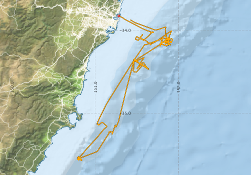
Voyage extents: 35° 34.3' S to 33° 49.6' S 150° 47.0' E to 151° 56.0' E Get voyage track shapefile Get CSV
Marlin Metadata:-
Participants - on ship:-
| Name | Role | Organisation |
|---|---|---|
| B Walker | OSI, University of Sydney | |
| CJ Jenkins | Chief Investigator | OSI, University of Sydney |
| D Mitchell | OSI, University of Sydney | |
| Erik Madsen | CSIRO Division of Oceanography | |
| F Wan | University of New South Wales - Centre for Marine Science | |
| Jock Keene | OSI, University of Sydney | |
| K List | University of New South Wales - Centre for Marine Science | |
| M de Mol | University of New South Wales - Centre for Marine Science | |
| RJ Edwards | CSIRO Division of Oceanography | |
| T Hull | Centre for Geotechnical Reserach, Uysd | |
| T van der Linden | OSI, University of Sydney | |
| Tom Hubble | OSI, University of Sydney |
This list includes those that may have only been on part of the voyage. See voyage reports on 'Reports and Maps' tab for details.
Marine National Facility Reports - plans, summaries and data processing
-
FR199105 Voyage Summary
- includes preliminary results, voyage narrative, types of data collected with C77/ROSCOP codes.
-
FR199105 Voyage Plan
- includes objectives, investigator details, proposed data collection, voyage track and equipment to be used.
-

Search for publications, reports and datasets from this and other voyages
Data publishing
This is a list of online datasets hosted by CSIRO. Other processed datasets hosted by collaborating organisations may be found on the 'Metadata' or "Reports, Publications and Maps' tab.
Use the Get data link on the right to extract data using the NCMI Data Trawler.
| Data Stream | Data Summary | Get data | ||||||||||||
|---|---|---|---|---|---|---|---|---|---|---|---|---|---|---|
| Underway |
|
Get Data from Trawler |
Deployments by start time:- Click on column header to sort. Use link on 'Deployment' to see full details. Use the CSV button at the bottom to export data (tab delimited).
Search for deployments from this voyage and others
| Deployment | Operation | Station | Cast | Gear | Project | Start and end times | Start Location | End Location | Depth range | Max Depth | Description | |||
|---|---|---|---|---|---|---|---|---|---|---|---|---|---|---|
| Underway System [details] | Simrad EA500 Echosounder | 107 | 1991-05-23 00:00 | 1991-05-30 23:55 | -33.8273 | 151.2830 | -33.8743 | 151.4220 | ||||||