Voyage details and related metadata, reports, events and data.
FR 06/89
(alternative identifier: FR198906)
- is a Marine National Facility ![]() voyage
voyage
Period: 1989-05-11 00:00 to 1989-05-15 00:00 Local
Duration: 4.00 days
From: Coffs Harbour To: Sydney
Region: NSW coast
Ship: Franklin [details]
Description: Cruise FR 06/89 was undertaken to study and collect whiting (Sillago sp.) and other fish larvae from the waters on the continental shelf off northern New South Wales and to examine their distribution and genetic relatedness in relation to oceanographic data collected in the same region. The effect of the East Australian Current on the water masses on the continental shelf in the same region was also studied. Survey methods included CTD profiles, ADCP, plankton net tows and other associated instrumentation. Samples of water and plankton were collected for on board analysis and laboratory study. Preliminary sorting of the plankton samples indicated that the whiting larvae were patchy in their distribution, being found in ten samples from four generalised areas.
Leader: P. Dixon (University of NSW) & M. Tomczak (University of Sydney)
Project: National Facility External Users: P. Dixon (University of NSW) [details]
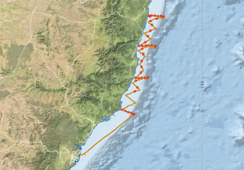
Voyage extents: 33° 51.3' S to 29° 34.4' S 151° 16.4' E to 153° 49.6' E Get voyage track shapefile Get CSV
Marlin Metadata:-
Participants - on ship:-
| Name | Role | Organisation |
|---|---|---|
| Andrew Forbes | Cruise Manager | CSIRO ORV |
| Bob Griffiths | CSIRO ORV | |
| Cesar Villanoy | University of Sydney | |
| Dave Edwards | CSIRO ORV | |
| Jeff Dunn | CSIRO ORV | |
| John Luick | University of Sydney | |
| Kate Warmus | University of Sydney | |
| Matthias Tomczak | Chief Scientist | University of Sydney |
| Neil Sims | University of New South Wales - Centre for Marine Science | |
| Patricia Dixon | University of New South Wales - Centre for Marine Science | |
| Tony Miskiewicz | University of New South Wales - Centre for Marine Science |
This list includes those that may have only been on part of the voyage. See voyage reports on 'Reports and Maps' tab for details.
Marine National Facility Reports - plans, summaries and data processing
-
FR198906 Voyage Summary
- includes preliminary results, voyage narrative, types of data collected with C77/ROSCOP codes.
-
FR198906 Voyage Plan
- includes objectives, investigator details, proposed data collection, voyage track and equipment to be used.
-

Search for publications, reports and datasets from this and other voyages
Data publishing
This is a list of online datasets hosted by CSIRO. Other processed datasets hosted by collaborating organisations may be found on the 'Metadata' or "Reports, Publications and Maps' tab.
Use the Get data link on the right to extract data using the NCMI Data Trawler.
| Data Stream | Data Summary | Get data | ||||||||||||||
|---|---|---|---|---|---|---|---|---|---|---|---|---|---|---|---|---|
| ADCP Data |
|
Get Data from Trawler Download ASCII dataset fr8906adcp.zip Download NetCDF dataset fr8906adcpCDF.zip |
||||||||||||||
| CTD profile |
|
Get Data from Trawler |
||||||||||||||
| Hydrology |
|
Get Data from Trawler |
||||||||||||||
| Underway |
|
Get Data from Trawler |
Deployments by start time:- Click on column header to sort. Use link on 'Deployment' to see full details. Use the CSV button at the bottom to export data (tab delimited).
Search for deployments from this voyage and others
| Deployment | Operation | Station | Cast | Gear | Project | Start and end times | Start Location | End Location | Depth range | Max Depth | Description | |||
|---|---|---|---|---|---|---|---|---|---|---|---|---|---|---|
| Underway System [details] | Simrad EA500 Echosounder | 126 | 1989-05-11 00:00 | 1989-05-14 23:55 | -29.6107 | 153.4060 | -33.8280 | 151.2740 | ||||||
| CTD Cast / Hydrology [details] | 1 | Cast 1 | 126 | 1989-05-11 06:36 | 1989-05-11 06:52 | -29.5800 | 153.3752 | -29.5840 | 153.3717 | 0 | ||||
| CTD Cast [details] | 1 | Cast 2 | 126 | 1989-05-11 07:33 | 1989-05-11 07:37 | -29.5753 | 153.4597 | -29.5762 | 153.4593 | 0 | ||||
| CTD Cast / Hydrology [details] | 1 | Cast 3 | 126 | 1989-05-11 08:36 | 1989-05-11 08:59 | -29.5777 | 153.5562 | -29.5840 | 153.5557 | 0 | ||||
| CTD Cast / Hydrology [details] | 1 | Cast 4 | 126 | 1989-05-11 09:43 | 1989-05-11 10:04 | -29.5935 | 153.6505 | -29.6065 | 153.6498 | 0 | ||||
| CTD Cast / Hydrology [details] | 1 | Cast 5 | 126 | 1989-05-11 11:01 | 1989-05-11 11:39 | -29.5893 | 153.7445 | -29.6132 | 153.7422 | 0 | ||||
| CTD Cast / Hydrology [details] | 1 | Cast 6 | 126 | 1989-05-11 12:32 | 1989-05-11 13:31 | -29.6077 | 153.8270 | -29.6473 | 153.8233 | 0 | ||||
| CTD Cast / Hydrology [details] | 1 | Cast 7 | 126 | 1989-05-11 15:18 | 1989-05-11 15:32 | -29.6703 | 153.6155 | -29.6753 | 153.6215 | 0 | ||||
| ADCP Data [details] | RDI VM-150 Acoustic Doppler current profiler | 126 | 1989-05-11 17:20 | 1989-05-14 21:40 | -29.7440 | 153.4300 | -33.8000 | 151.3900 | 256.8 | |||||
| CTD Cast / Hydrology [details] | 1 | Cast 8 | 126 | 1989-05-11 20:04 | 1989-05-11 20:18 | -29.8597 | 153.4692 | -29.8635 | 153.4697 | 0 | ||||
| CTD Cast / Hydrology [details] | 1 | Cast 9 | 126 | 1989-05-11 23:14 | 1989-05-11 23:28 | -30.0393 | 153.4210 | -30.0452 | 153.4200 | 0 | ||||
| CTD Cast / Hydrology [details] | 1 | Cast 10 | 126 | 1989-05-12 02:38 | 1989-05-12 02:52 | -30.2030 | 153.3468 | -30.2083 | 153.3453 | 0 | ||||
| CTD Cast / Hydrology [details] | 1 | Cast 11 | 126 | 1989-05-12 05:43 | 1989-05-12 05:56 | -30.3892 | 153.2718 | -30.3952 | 153.2700 | 0 | ||||
| CTD Cast / Hydrology [details] | 1 | Cast 12 | 126 | 1989-05-12 08:09 | 1989-05-12 08:19 | -30.5002 | 153.0840 | -30.5013 | 153.0848 | 0 | ||||
| CTD Cast / Hydrology [details] | 1 | Cast 13 | 126 | 1989-05-12 09:00 | 1989-05-12 09:12 | -30.5015 | 153.1812 | -30.5062 | 153.1827 | 0 | ||||
| CTD Cast / Hydrology [details] | 1 | Cast 14 | 126 | 1989-05-12 09:57 | 1989-05-12 10:20 | -30.4877 | 153.2838 | -30.4965 | 153.2775 | 0 | ||||
| CTD Cast / Hydrology [details] | 1 | Cast 15 | 126 | 1989-05-12 11:15 | 1989-05-12 11:50 | -30.4842 | 153.3662 | -30.5095 | 153.3627 | 0 | ||||
| CTD Cast / Hydrology [details] | 1 | Cast 16 | 126 | 1989-05-12 12:49 | 1989-05-12 13:58 | -30.4853 | 153.4595 | -30.5405 | 153.4312 | 0 | ||||
| CTD Cast / Hydrology [details] | 1 | Cast 17 | 126 | 1989-05-12 15:11 | 1989-05-12 16:56 | -30.5090 | 153.5715 | -30.5785 | 153.5677 | 0 | ||||
| CTD Cast / Hydrology [details] | 1 | Cast 18 | 126 | 1989-05-12 20:23 | 1989-05-12 20:37 | -30.5925 | 153.1712 | -30.5985 | 153.1723 | 0 | ||||
| CTD Cast / Hydrology [details] | 1 | Cast 19 | 126 | 1989-05-12 23:05 | 1989-05-12 23:18 | -30.7425 | 153.2112 | -30.7485 | 153.2115 | 0 | ||||
| CTD Cast / Hydrology [details] | 1 | Cast 20 | 126 | 1989-05-13 01:40 | 1989-05-13 01:55 | -30.9577 | 153.1587 | -30.9668 | 153.1592 | 0 | ||||
| CTD Cast / Hydrology [details] | 1 | Cast 21 | 126 | 1989-05-13 03:38 | 1989-05-13 03:51 | -31.1440 | 153.1565 | -31.1488 | 153.1572 | 0 | ||||
| CTD Cast / Hydrology [details] | 1 | Cast 22 | 126 | 1989-05-13 05:28 | 1989-05-13 05:42 | -31.3090 | 153.1343 | -31.3148 | 153.1327 | 0 | ||||
| CTD Cast / Hydrology [details] | 1 | Cast 23 | 126 | 1989-05-13 07:33 | 1989-05-13 07:47 | -31.4732 | 152.9758 | -31.4728 | 152.9765 | 0 | ||||
| CTD Cast / Hydrology [details] | 1 | Cast 24 | 126 | 1989-05-13 08:43 | 1989-05-13 09:04 | -31.4878 | 153.0673 | -31.4875 | 153.0672 | 0 | ||||
| CTD Cast / Hydrology [details] | 1 | Cast 25 | 126 | 1989-05-13 09:49 | 1989-05-13 10:20 | -31.4705 | 153.1648 | -31.4878 | 153.1617 | 0 | ||||
| CTD Cast / Hydrology [details] | 1 | Cast 26 | 126 | 1989-05-13 11:24 | 1989-05-13 12:05 | -31.4748 | 153.2578 | -31.5018 | 153.2600 | 0 | ||||
| CTD Cast / Hydrology [details] | 1 | Cast 27 | 126 | 1989-05-13 13:02 | 1989-05-13 14:05 | -31.4658 | 153.3512 | -31.5122 | 153.3452 | 0 | ||||
| CTD Cast / Hydrology [details] | 1 | Cast 28 | 126 | 1989-05-13 17:03 | 1989-05-13 17:15 | -31.5572 | 152.9853 | -31.5727 | 152.9798 | 0 | ||||
| CTD Cast / Hydrology [details] | 1 | Cast 29 | 126 | 1989-05-13 20:42 | 1989-05-13 20:56 | -31.7687 | 153.0295 | -31.7703 | 153.0295 | 0 | ||||
| CTD Cast / Hydrology [details] | 1 | Cast 30 | 126 | 1989-05-13 22:39 | 1989-05-13 22:52 | -31.8860 | 152.9528 | -31.8818 | 152.9528 | 0 | ||||
| CTD Cast / Hydrology [details] | 1 | Cast 31 | 126 | 1989-05-14 07:14 | 1989-05-14 07:25 | -32.4478 | 152.5655 | -32.4450 | 152.5675 | 0 | ||||
| CTD Cast / Hydrology [details] | 1 | Cast 32 | 126 | 1989-05-14 08:25 | 1989-05-14 08:50 | -32.4855 | 152.6658 | -32.4792 | 152.6713 | 0 | ||||
| CTD Cast / Hydrology [details] | 1 | Cast 33 | 126 | 1989-05-14 09:32 | 1989-05-14 09:56 | -32.5213 | 152.7540 | -32.5180 | 152.7542 | 0 | ||||
| CTD Cast / Hydrology [details] | 1 | Cast 34 | 126 | 1989-05-14 10:36 | 1989-05-14 11:06 | -32.5457 | 152.8500 | -32.5617 | 152.8337 | 0 | ||||
| CTD Cast / Hydrology [details] | 1 | Cast 35 | 126 | 1989-05-14 11:48 | 1989-05-14 12:30 | -32.5870 | 152.9218 | -32.6018 | 152.9068 | 0 | ||||