Survey details and related metadata, reports, events and data.
DM 5/64 (alternative identifier: DM196405)
Period: 1964-08-10 00:00 to 1964-09-10 00:00 Local
Duration: 31.00 days
Region: E Indian Ocean (Fremantle-Singapore)
Ship: Diamantina [details]
Description: H.M.A.S Diamantina cruise Dm 5/64 was undertaken for suspended particulate matter studies, hydrology, primary production, zooplankton and particulate matter sampling in the east Indian Ocean off Western Australia.
Leader: B. Newell (CSIRO)
Project: "Diamantina" and "Gascoyne" oceanographic surveys, Indian Ocean/Western Australia/GAB, 1959-1965 (+1979) [details]
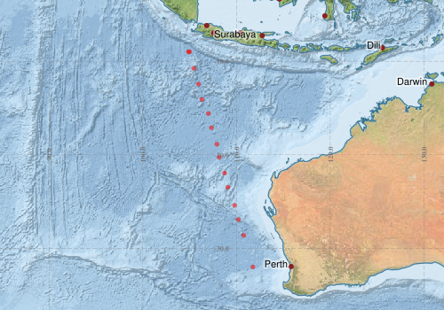
Voyage extents: 32° 00.0' S to 8° 58.0' S 104° 53.0' E to 111° 45.0' E
Marlin Metadata:-

Participants:- no records
Marine National Facility Reports - plans, summaries and data processing
- View the Survey Summary report - includes preliminary results, voyage narrative, types of data collected with C77/ROSCOP codes.
- There is no map for this survey.
Search for publications, reports and datasets from this and other voyages
Data publishing
This is a list of online datasets hosted by CSIRO. Other processed datasets hosted by collaborating organisations may be found on the 'Metadata' or "Reports, Publications and Maps' tab.
Use the Get data link on the right to extract data using the NCMI Data Trawler.
| Data Stream | Data Summary | Get data | ||||||||||
|---|---|---|---|---|---|---|---|---|---|---|---|---|
| Marine biodiversity observations and/or samples |
|
Get Data from Trawler |
||||||||||
| Hydrology |
|
Get Data from Trawler |
Deployments by start time:- Click on column header to sort. Use link on 'Deployment' to see full details. Use the CSV button at the bottom to export data (tab delimited).
Search for deployments from this voyage and others
| Deployment | Operation | Station | Cast | Gear | Project | Start and end times | Start Location | End Location | Depth range | Max Depth | Description | |||
|---|---|---|---|---|---|---|---|---|---|---|---|---|---|---|
| Hydrology Cast [details] | 1 | 30 | 1964-08-11 00:00 | 1964-08-11 00:00 | -32.0000 | 111.7500 | 4482 | |||||||
| Hydrology Cast [details] | 1 | 30 | 1964-08-12 00:15 | 1964-08-12 00:15 | -28.6167 | 110.7833 | 4883 | |||||||
| Hydrology Cast [details] | 1 | 30 | 1964-08-13 00:00 | 1964-08-13 00:00 | -25.4000 | 109.8000 | 3458 | |||||||
| Hydrology Cast [details] | 1 | 30 | 1964-08-14 00:30 | 1964-08-14 00:30 | -21.9500 | 108.7333 | 2440 | |||||||
| Hydrology Cast [details] | 1 | 30 | 1964-08-15 00:00 | 1964-08-15 00:00 | -18.8667 | 107.9167 | 5000 | |||||||
| Hydrology Cast [details] | 1 | 30 | 1964-08-16 00:00 | 1964-08-16 00:00 | -15.5833 | 107.0000 | 4960 | |||||||
| Hydrology Cast [details] | 1 | 30 | 1964-08-17 03:30 | 1964-08-17 03:30 | -12.4333 | 105.9500 | 4898 | |||||||
| Hydrology Cast [details] | 1 | 30 | 1964-08-18 01:00 | 1964-08-18 01:00 | -8.9667 | 104.9833 | 4787 | |||||||
| Hydrology Cast [details] | 1 | 30 | 1964-08-31 06:30 | 1964-08-31 06:30 | -9.0000 | 104.8833 | 4245 | |||||||
| Hydrology Cast [details] | 1 | 30 | 1964-09-03 02:15 | 1964-09-03 02:15 | -10.7500 | 105.4333 | 3898 | |||||||
| Hydrology Cast [details] | 1 | 30 | 1964-09-04 01:00 | 1964-09-04 01:00 | -14.0667 | 106.3000 | 4903 | |||||||
| Hydrology Cast [details] | 1 | 30 | 1964-09-05 01:00 | 1964-09-05 01:00 | -17.1000 | 107.3333 | 4863 | |||||||
| Hydrology Cast [details] | 1 | 30 | 1964-09-06 01:00 | 1964-09-06 01:00 | -20.2667 | 108.1500 | 3951 | |||||||
| Hydrology Cast [details] | 1 | 30 | 1964-09-07 01:00 | 1964-09-07 01:00 | -23.4667 | 109.0833 | 2824 | |||||||
| Hydrology Cast [details] | 1 | 30 | 1964-09-08 07:00 | 1964-09-08 07:00 | -26.9333 | 110.2000 | 3725 | |||||||