Please login if you have access to particular applications.
Catch Data - from CSIRO surveys.
| CAAB Code: | 37 384083 [taxon report] |
| Scientific Name and Authority: | Cirrhilabrus punctatus Randall & Kuiter, 1989 |
| CAAB category: | 37 - Pisces |
| Standard Name (AS 5300): | Finespot Wrasse |
Distribution map:
View detailed map or click on map to see same.
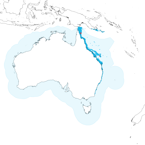
Modelled distribution shown as blue polygon (source: Australian National Fish Expert Distributions) Updated on 2008-11-19.
Occurrence locations [5] shown as red circles - View CSIRO Catch records Get expert distribution shapefile
View detailed map or click on map to see same.
Modelled distribution shown as blue polygon (source: Australian National Fish Expert Distributions) Updated on 2008-11-19.
Occurrence locations [5] shown as red circles - View CSIRO Catch records Get expert distribution shapefile
Catch records - 5 records found.
Click on survey to see survey details. Click on Operation to see full details of the catch. Use the CSV button at the bottom to export data.
| Date (UTC) | Position | Survey | Operation | Depth Range (m) | Count | Weight (kg) | Method | Effort | Gear |
|---|---|---|---|---|---|---|---|---|---|
| 2005-02-04 12:13 | 11° 56.1' S 143° 46.5' E | LB200501 | 148 | 28 to 28 | 1 | Benthic Sled | |||
| 2005-02-07 07:58 | 12° 14.7' S 143° 48.9' E | LB200501 | 166 | 26 to 26 | 2 | Benthic Sled | |||
| 2005-02-07 09:39 | 12° 20.1' S 143° 43.5' E | LB200501 | 167 | 24 to 24 | 1 | Benthic Sled | |||
| 2005-11-17 00:56 | 21° 57.3' S 152° 15.9' E | LB200502 | 138 | 67 to 67 | 1 | Benthic Sled | |||
| 2005-11-23 11:01 | 21° 57.3' S 152° 15.9' E | GM200501 | 45 | 67 to 67 | 1 | Prawn Trawl |