Please login if you have access to particular applications.
Provider: All providers | |
Key Ecological Features | |
| Name: | Tasmantid seamount chain - view region report showing all data |
| Region: | Temperate east |
| Area: | 23,581.74 km2 |
| Gear type: | CTD sensor
|
| Layers used: |
CMAR CTD Data Overview (1982 - present)
- link to layer metadata CMAR Towed CTD - link to layer metadata ARGO profile map - link to layer metadata |
| Summary: | Records - 122 Deepest: db |
| Last updated: | 18-Mar-2024 06:30. |
| Buffer: | |
Time series plot (1930 to present) - Y axis is deployments as vertical profile or tows per year
Region data
Show data list
| Year | Total inside region |
| 1985 | 3 |
| 1989 | 2 |
| 1990 | 2 |
| 1991 | 8 |
| 1999 | 3 |
| 2004 | 1 |
| 2004 | 15 |
| 2006 | 2 |
| 2006 | 16 |
| 2007 | 4 |
| 2008 | 4 |
| 2009 | 5 |
| 2009 | 67 |
| 2010 | 8 |
| 2011 | 5 |
| 2012 | 3 |
| 2012 | 5 |
| 2013 | 2 |
| 2013 | 6 |
| 2014 | 3 |
| 2015 | 1 |
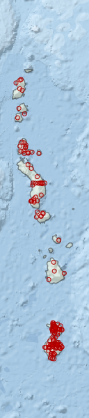
Region extents: 154° 43.5' E 33° 33.7' S to 156° 56.2' E 24° 29.9' S
Acknowledgements: Background map - Bright Earth e-Atlas Basemap v1.0 (AIMS, GBRMPA, JCU, DSITIA, GA, UCSD, NASA, OSM, ESRI) CC BY