|
|
|||
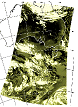
C-squares examplesSample C-squares-enabled applications, as at mid-2011(1) "MarLIN" - CSIRO Marine and Atmospheric Research data directory (metadata system)
- using c-squares for spatial searching and mapping, via stored c-squares index
NB: look for the link "Click here to show data coverage by 0.5 degree squares" near the top of any metadata record.
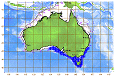
(2) "CAAB" (Codes for Australian Aquatic Biota) - CSIRO Marine and Atmospheric Research marine species database
- using c-squares for mapping, plus onward active (clickable) "quick maps", via stored c-squares index
(3) CSIRO Marine and Atmospheric Research Satellite Data Archive
- using c-squares for spatial searching, and mapping of scene footprints, via stored c-squares index
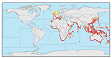
(4) OBIS, the Ocean Biogeographic Information System - access to global distribution data on 30,000+ marine species
- using c-squares for spatial searching, mapping, plus onward active (clickable) "quick maps", via stored c-squares index
(5) CSIRO Marine and Atmospheric Research marine species modelled distributions (live mapping and data extraction currently restricted to CMAR staff only, however sample pages below are open access)
- using c-squares for interactive map generation, selecting from a stored list of potential c-squares according to inputted parameters
(6, 7) Other systems: FishBase
- using c-squares for on-demand mapping, via on-the-fly lat/lon-to-c-square conversions
(8) "Mapping Tools" development site at Australian Antarctic Division
- includes ColdFusion tools for c-squares encoding; encoded examples (points, squares, and a research voyage); and prototype implementations of c-squares mappers in Flash and SVG (Scalable Vector Graphics)
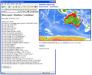
(9) Database reporting tool (prototype as at Sep 2005)
- includes reports on data lats/lons in specified ranges, data points on land (using a c-squares lookup table), and on-the-fly data mapping by 0.5 degree square (e.g. 120,000 records, occupying 840 squares in this instance)
(10) AquaMaps project (IfM-Geomar, Kiel, Germany)
- aiming to produce on-line predictive maps for all marine species, based on ecological niche and habitat modelling, and expert input. Species occurrence data and ecological data are "binned" by half degree squares, passed through species-specific environmental modelling envelopes, then the result sent to the CMAR c-squares mapper for on-the-fly map generation (colour-coded maps showing the distribution of 5 probability classes for a given species)
|