Voyage details and related metadata, reports, events and data.
ST 03/2008
(alternative identifier: ST200803)
- is a Marine National Facility ![]() voyage
voyage
Period: 2008-08-12 00:00 to 2008-08-16 00:00 UTC
Duration: 4.00 days
From: Gladstone To: Sydney
Region: Queensland Coast, New South Wales Coast
Ship: Southern Surveyor [details]
Description: Voyage Objectives: i) To make targeted swath mapping around the 400 m isobath from Gladstone to Sydney;ii) To make CTD casts for nutrients and take Rectangular Midwater Trawls (RMT) and surface neuston net hauls inside and outside eddies that are encountered on the voyage south (to be guided by MODIS images and BlueLink forecasts during the week before departure); most plankton samples will be preserved in formalin;iii) To make standard 1 hour counts of seabirds and any marine mammals at dawn, midday and dusk from the bridge, and separate, particular counts in areas leading up to and within any particular oceanographic feature (e.g. an eddy or front); iv) To monitor the ADCP and underway data (T, S and fluorescence at 4 m intake) as the vessel crosses eddies and other oceanographic features;v) To collect seawater samples and trial new instrumentation in the Fish Lab. Taken from ST 3/2008 Voyage Plan
Leader: Ross Hill (UTS)
Project: National Facility External Users: Ross Hill (UTS) [details]
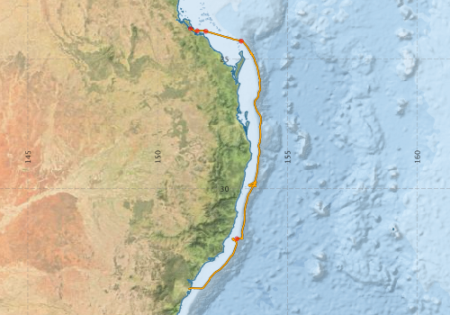
Voyage extents: 33° 51.8' S to 23° 50.0' S 151° 11.0' E to 153° 58.5' E
Marlin Metadata:-
Participants - on ship:-
| Name | Role | Organisation |
|---|---|---|
| Adrienne Gatt | Student | University of New South Wales - Centre for Marine Science |
| Ben Harris | Student | University of New South Wales - Centre for Marine Science |
| Bob Beattie | MNF Computing, Voyage Manager | CSIRO Oceans & Atmosphere - Hobart |
| Dave Terhell | MNF Hydrochemistry Support | CSIRO Oceans & Atmosphere - Hobart |
| Drew Mills | MNF Electronics Support | CSIRO Oceans & Atmosphere - Hobart |
| Halley Durrant | Student | University of New South Wales - Centre for Marine Science |
| Hayden Quinn | Student | University of Technology, Sydney |
| Jason Everett | Alternative Chief Scientist | University of New South Wales - Centre for Marine Science |
| Jennifer Clarke | Student | University of Technology, Sydney |
| Kate Berry | Analytical Chemist | CSIRO Oceans & Atmosphere - Hobart |
| Kristina Paterson | Analytical Chemist | CSIRO Oceans & Atmosphere - Hobart |
| Madeleine D?Arcy | Student | University of Sydney |
| Ross Hill | Chief Investigator | University of Technology, Sydney |
| Sam Avery | Student | University of Technology, Sydney |
This list includes those that may have only been on part of the voyage. See voyage reports on 'Reports and Maps' tab for details.
Marine National Facility Reports - plans, summaries and data processing
-
ST200803 Voyage Plan
- includes objectives, investigator details, proposed data collection, voyage track and equipment to be used.
-
ST200803 Voyage Summary
- includes preliminary results, voyage narrative, types of data collected with C77/ROSCOP codes.
-
ST200803 Scientific Highlight
- report of the key outputs
-

Publications, reports and datasets from this voyage.
Dataset
- Bakker, Dorothee C E; Pfeil, Benjamin; Smith, Karl; Hankin, Steven; Olsen, Are; Alin, Simone R; Cosca, Catherine E; Harasawa, Sumiko; Kozyr, Alexander; Nojiri, Yukihiro; O'Brien, Kevin M; Schuster, Ute; Telszewski, Maciej; Tilbrook, Bronte; Wada, Chisato; Akl, John; Barbero, Leticia; Bates, Nicolas R; Boutin, Jacqueline; Bozec, Yann; Cai, Wei-Jun; Castle, Robert D; Chavez, Francisco P; Chen, Lei; Chierici, Melissa; Currie, Kim I; de Baar, Hein J W; Evans, Wiley; Feely, Richard A; Fransson, Agneta; Gao, Zhongyong; Hales, Burke; Hardman-Mountford, Nicolas J; Hoppema, Mario; Huang, Wei-Jen; Hunt, Christopher W; Huss, Betty; Ichikawa, Tadafumi; Johannessen, Truls; Jones, Elizabeth M; Jones, Steve D; Jutterstrøm, Sara; Kitidis, Vassilis; Körtzinger, Arne; Landschützer, Peter; Lauvset, Siv K; Lefèvre, Nathalie; Manke, Ansley; Mathis, Jeremy T; Merlivat, Liliane; Metzl, Nicolas; Murata, Akihiko; Newberger, Timothy; Omar, Abdirahman M; Ono, Tsuneo; Park, Geun-Ha; Paterson, Kristina; Pierrot, Denis; Ríos, Aida F; Sabine, Christopher L; Saito, Shu; Salisbury, Joe; Sarma, Vedula V S S; Schlitzer, Reiner; Sieger, Rainer; Skjelvan, Ingunn; Steinhoff, Tobias; Sullivan, Kevin; Sun, Heng; Sutton, Adrienne; Suzuki, Toru; Sweeney, Colm; Takahashi, Taro; Tjiputra, Jerry; Tsurushima, Nobuo; van Heuven, Steven; Vandemark, Doug; Vlahos, Penny; Wallace, Douglas WR; Wanninkhof, Rik; Watson, Andrew J (2014): Surface Ocean CO2 Atlas (SOCAT) V2. PANGAEA, 10.1594/PANGAEA.811776
- Smith, S. R.,Lopez, N.,Bourassa, M. A. (2016) SAMOS air‐sea fluxes: 2005–2014. Geoscience Data Journal 3 pp9-19. 10.1002/gdj3.34
Search for publications, reports and datasets from this and other voyages
Data publishing
This is a list of online datasets hosted by CSIRO. Other processed datasets hosted by collaborating organisations may be found on the 'Metadata' or "Reports, Publications and Maps' tab.
Use the Get data link on the right to extract data using the NCMI Data Trawler.
| Data Stream | Data Summary | Get data | ||||||||||||||
|---|---|---|---|---|---|---|---|---|---|---|---|---|---|---|---|---|
| ADCP Data |
|
Get Data from Trawler Download netCDF dataset st200803adcp.zip ST200803_UWY_ADCP_Report.pdf |
||||||||||||||
| Multibeam echosounder |
|
Get Data from Trawler |
||||||||||||||
| pCO2 |
|
External link - download datafile at IMOS |
||||||||||||||
| Underway |
|
Get Data from Trawler |
||||||||||||||
| XBT Profile |
|
Get Data from Trawler Download xbt_ascii_ma_2007_2012.zip (MEDS ASCII format ) Download xbt_nc_ss2007_2012.zip (NetCDF format) |
Deployments by start time:- Click on column header to sort. Use link on 'Deployment' to see full details. Use the CSV button at the bottom to export data (tab delimited).
Search for deployments from this voyage and others
| Deployment | Operation | Station | Cast | Gear | Project | Start and end times | Start Location | End Location | Depth range | Max Depth | Description | |||
|---|---|---|---|---|---|---|---|---|---|---|---|---|---|---|
| Underway System [details] | Air Temperature Sensor-HMP233,Barometer,Fluorometer WS3S-443P,Gyro-Generic SS-NF,Humidity Sensor-HMP233,IMOS Port Pyranometer-SN 35122F3,IMOS Port Radiometer-SN 35111F3,IMOS Stbd Pyranometer-SN 35123F3,IMOS Stbd Radiometer-SN 35093F3,IMOS rain gauge,IMOS rain gauge,IMOS wind monitor,IMOS wind monitor,IMOS wind monitor,IMOS wind monitor,Licor-UWQ 3708,RM Young 05106 wind monitor-75621,RM Young 05106 wind monitor-75621,RM Young 05106 wind monitor-75621,RM Young Rain Gauge,Seapath 200,Seapath 200,Simrad EA500 Echosounder,ThermoSalinoGraph (TSG)-SS-SN 1777,ThermoSalinoGraph (TSG)-SS-SN 1777 | 2359 | 2008-08-11 23:51 | 2008-08-16 04:24 | -23.8330 | 151.2632 | -33.8636 | 151.1829 | ||||||
| Multibeam echosounder [details] | EM300 Multibeam Echosounder | 2008-08-12 01:31 | 2008-08-16 02:39 | -23.9205 | 151.5242 | -33.8398 | 151.3783 | 2582 | ||||||
| ADCP Data [details] | RDI Ocean Surveyor Acoustic Doppler current profiler | 2359 | 2008-08-12 03:07 | 2008-08-16 03:29 | -23.9358 | 151.8525 | -33.8297 | 151.3043 | 646 | |||||
| XBT Cast [details] | Sippican Deep Blue | 2391 | 2008-08-12 10:01 | -24.3105 | 153.2185 | 1093.2 | ||||||||
| XBT Cast [details] | Sippican Deep Blue | 2391 | 2008-08-14 23:37 | -31.9332 | 153.0531 | 1100.3 | ||||||||