Voyage details and related metadata, reports, events and data.
ST 03/2006
(alternative identifier: ST200603)
- is a Marine National Facility ![]() voyage
voyage
Period: 2006-10-26 02:00 to 2006-10-29 03:00 UTC
Duration: 3.04 days
From: Sydney To: Hobart
Region: NSW coast, Bass Strait, Tasmanian East Coast
Ship: Southern Surveyor [details]
Description: Southern surveyor Transit voyage ST200603 from Sydney to Hobart. Only Underway data collected.
Project: National Facility External Users: C. Buchannan (Geoscience Australia) [details]
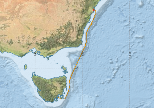
Voyage extents: 43° 16.0' S to 33° 49.7' S 147° 22.5' E to 151° 26.2' E Get voyage track shapefile Get CSV
Metadata - No Marlin metadata records found or has not been linked to this survey or potentially the metadata catalogue is offline.
Participants - on ship:-
| Name | Role | Organisation |
|---|---|---|
| Andrew Krassay | Swathe/SBP trainee | Geoscience Australia |
| Cameron Buchanan | Chief Investigator | Geoscience Australia |
| Cameron Mitchell | Supervisor for trainees | Geoscience Australia |
| Chris Boreham | Swathe/SBP trainee | Geoscience Australia |
| Chris Nicholson | Swathe/SBP trainee | Geoscience Australia |
| Fred Kroh | SBP Specialist | Geoscience Australia |
| Lindsay MacDonald | Electronics | CSIRO Oceans & Atmosphere - Hobart |
| Stephen Thomas | Voyage Manager/Electronics | CSIRO Oceans & Atmosphere - Hobart |
| Tony Hill | Swathe/SBP trainee | PIRSA |
This list includes those that may have only been on part of the voyage. See voyage reports on 'Reports and Maps' tab for details.
Marine National Facility Reports - plans, summaries and data processing
-
ST200603 Underway Data Processing Report
- details of data processing steps, calibration information, instruments used and any issues with the data.
-
ST200603 Voyage Plan
- includes objectives, investigator details, proposed data collection, voyage track and equipment to be used.
-

Search for publications, reports and datasets from this and other voyages
Data publishing
This is a list of online datasets hosted by CSIRO. Other processed datasets hosted by collaborating organisations may be found on the 'Metadata' or "Reports, Publications and Maps' tab.
Use the Get data link on the right to extract data using the NCMI Data Trawler.
| Data Stream | Data Summary | Get data | ||||||||||||
|---|---|---|---|---|---|---|---|---|---|---|---|---|---|---|
| Multibeam echosounder |
|
Get Data from Trawler |
||||||||||||
| Underway |
|
Get Data from Trawler |
Deployments by start time:- Click on column header to sort. Use link on 'Deployment' to see full details. Use the CSV button at the bottom to export data (tab delimited).
Search for deployments from this voyage and others
| Deployment | Operation | Station | Cast | Gear | Project | Start and end times | Start Location | End Location | Depth range | Max Depth | Description | |||
|---|---|---|---|---|---|---|---|---|---|---|---|---|---|---|
| Underway System [details] | Air Temperature Sensor-HMP233,Barometer,Fluorometer WS3S-443P,Gyro-Generic SS-NF,Humidity Sensor-HMP233,Licor-UWQ 3708,RM Young 05103 wind monitor,RM Young 05103 wind monitor,RM Young 05103 wind monitor,RM Young Rain Gauge,Seapath 200,Seapath 200,Simrad EA500 Echosounder,ThermoSalinoGraph (TSG)-SS-SN 1777,ThermoSalinoGraph (TSG)-SS-SN 1777 | 2229 | 2006-10-26 03:00 | 2006-10-29 06:33 | -33.8621 | 151.1855 | -43.0174 | 147.3758 | ||||||
| Multibeam echosounder [details] | EM300 Multibeam Echosounder | 2006-10-26 08:03 | 2006-10-30 03:21 | -33.8621 | 151.1854 | -42.8863 | 147.3386 | 4650.1 | ||||||