Voyage details and related metadata, reports, events and data.
SS2013_V02
- is a Marine National Facility ![]() voyage
voyage
Period: 2013-02-08 00:00 to 2013-02-24 21:00 UTC
Duration: 16.88 days
From: Brisbane To: Sydney
Region: Nothern Tasman Sea, south of Lord Howe Island and Lord Howe Island Marine Park.
Ship: Southern Surveyor [details]
Description: MNF Southern Surveyor research voyage SS2013_v02.Carbonate sedimentation at the southern margin of reef growth in the Tasman Sea. Scientific Objectives This research aims to determine the extent and composition of carbonate environments on and around volcanic edifices in the northern Tasman Sea. We plan to undertake the following investigations, listed in order of priority: 1. Examine the bathymetry and sedimentary environments across the shelf around Balls Pyramid, the remnant of a volcanic island just south of Lord Howe Island, from which such data are presently lacking; this will provide a basis for a more complete mapping of benthic habitats in the Lord Howe Marine Park. 2. Establish, using underwater towed video, whether a relict reef exists on the Balls Pyramid platform; this will confirm preliminary evidence that there may be a feature similar to the fossil reef on the shelf around Lord Howe, and would make it the southernmost known reef in the Pacific. Extend towed video to map major habitats of the Lord Howe Island Marine Park. 3. Extract rock cores from the Lord Howe relict reef (and that on the Balls platform, if found) providing material for component, age and geochemical determinations that will yield further insights into sea-level and climate (including palaeotemperature) history. 4. Collect vibrocores from the inner shelf on the Lord Howe shelf (and on the Balls platform if suitable areas are identified), in the lee of the relict reef, to determine the stratigraphy, source and depositional history of sequences of sediment revealed on Topas sub-bottom profiles and which appear to contain generations of 'lagoonal' sediment perhaps indicating that earlier reef features predated, and may underlie, the relict reef. 5. Undertake preliminary bathymetry transects and Topas sub-bottom profiles across the margin of Middleton and Elizabeth Reefs on the transit voyage to Lord Howe Island as a pilot study to better plan further data collection around these reefs in 2014. 6. Determine whether terraces identified on the shelf edge contain evidence of earlier episodes of reef development or are cut into basalt; this will provide evidence of sea level, clarifying the nature of the shoreline when the sea was at these heights (60-70m water depth), and would extend known distribution of pre-Holocene reef if shown to be biogenic features. 7. Examine slump features around both volcanic edifices to clarify their extent, and the nature and composition of sediment that covers them; this will clarify the post-eruptive history of the volcanic islands, and show the degree to which carbonate sediment from the shelf or hemipelagic sediment veneers their margins. 8. Resolve the morphology of the toe of the volcanoes, and collect mulitbeam sonar data on one or more of the small seamounts that have been detected adjacent to the Lord Howe volcano; this will clarify the nature of sediments and sedimentary deposits at the toe, and provide insights into the origin and benthic habitats of previously unknown seamounts. 9. Deploy sea-surface drifters to track ocean currents along the eastern margin of Australia. Drifters are expendable (not recovered) and can be deployed while underway.
Leader: C. Woodroffe (U Woollongong)
Project: National Facility External Users: C. Woodroffe (University of Wollongong) [details]
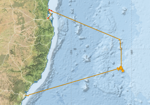
Voyage extents: 33° 55.0' S to 26° 43.8' S 151° 11.1' E to 159° 21.9' E Get voyage track shapefile Get CSV
Marlin Metadata:-
Metadata from OBIS Australia datasets:- biological data is published via the OBIS-AU IPT server and delivered to one or more of OBIS, ALA and GBIF
Download from OBIS Australia IPT View at - Ocean Biodiversity Information System (OBIS) Atlas of Living Australia (ALA) GBIF
Participants - on ship:-
| Name | Role | Organisation |
|---|---|---|
| Brendan Brooke | Deputy Chief Scientist | Geoscience Australia |
| Brett Muir | MNF Electronics | CSIRO Marine and Atmospheric Research |
| Bruce Barker | MNF Voyage Manager | CSIRO Marine and Atmospheric Research |
| Chris Gallen | Tow video operations | DPI |
| Colin Woodroffe | Chief Scientist | SEES, UOW |
| Craig Wintle | Mechanical Technician | Geoscience Australia |
| Hugh Barker | MNF Computing Support | CSIRO Marine and Atmospheric Research |
| Kim Picard | GIS/acoustics and Topas | Geoscience Australia |
| Mark Sharah | Mechanical Technician | Geoscience Australia |
| Matthew Carey | Electronics technician (tow video) | Geoscience Australia |
| Michelle Linklater | PhD student, benthic mapping | SEES, UOW |
| Rick Smith | MNF Swath support | CSIRO Marine and Atmospheric Research |
| Scott Nichol | Geologist | Geoscience Australia |
| Stephen Hodgkin | Electronics technician (tow video) | Geoscience Australia |
| Tanya Whiteway | Scientist | Geoscience Australia |
| Tara Martin | MNF Swath support | CSIRO Marine and Atmospheric Research |
This list includes those that may have only been on part of the voyage. See voyage reports on 'Reports and Maps' tab for details.
Marine National Facility Reports - plans, summaries and data processing
-
SS2013_V02 Voyage Plan
- includes objectives, investigator details, proposed data collection, voyage track and equipment to be used.
-
SS2013_V02 Underway Data Processing Report
- details of data processing steps, calibration information, instruments used and any issues with the data.
-
SS2013_V02 Voyage Summary
- includes preliminary results, voyage narrative, types of data collected with C77/ROSCOP codes.
-

Publications, reports and datasets from this voyage.
Dataset
- Bakker, Dorothee C E; Pfeil, Benjamin; Smith, Karl; Hankin, Steven; Olsen, Are; Alin, Simone R; Cosca, Catherine E; Harasawa, Sumiko; Kozyr, Alexander; Nojiri, Yukihiro; O'Brien, Kevin M; Schuster, Ute; Telszewski, Maciej; Tilbrook, Bronte; Wada, Chisato; Akl, John; Barbero, Leticia; Bates, Nicolas R; Boutin, Jacqueline; Bozec, Yann; Cai, Wei-Jun; Castle, Robert D; Chavez, Francisco P; Chen, Lei; Chierici, Melissa; Currie, Kim I; de Baar, Hein J W; Evans, Wiley; Feely, Richard A; Fransson, Agneta; Gao, Zhongyong; Hales, Burke; Hardman-Mountford, Nicolas J; Hoppema, Mario; Huang, Wei-Jen; Hunt, Christopher W; Huss, Betty; Ichikawa, Tadafumi; Johannessen, Truls; Jones, Elizabeth M; Jones, Steve D; Jutterstrøm, Sara; Kitidis, Vassilis; Körtzinger, Arne; Landschützer, Peter; Lauvset, Siv K; Lefèvre, Nathalie; Manke, Ansley; Mathis, Jeremy T; Merlivat, Liliane; Metzl, Nicolas; Murata, Akihiko; Newberger, Timothy; Omar, Abdirahman M; Ono, Tsuneo; Park, Geun-Ha; Paterson, Kristina; Pierrot, Denis; Ríos, Aida F; Sabine, Christopher L; Saito, Shu; Salisbury, Joe; Sarma, Vedula V S S; Schlitzer, Reiner; Sieger, Rainer; Skjelvan, Ingunn; Steinhoff, Tobias; Sullivan, Kevin; Sun, Heng; Sutton, Adrienne; Suzuki, Toru; Sweeney, Colm; Takahashi, Taro; Tjiputra, Jerry; Tsurushima, Nobuo; van Heuven, Steven; Vandemark, Doug; Vlahos, Penny; Wallace, Douglas WR; Wanninkhof, Rik; Watson, Andrew J (2014): Surface Ocean CO2 Atlas (SOCAT) V2. PANGAEA, 10.1594/PANGAEA.811776
- Linklater, Michelle (2018), “Classified benthic data for mesophotic organisms and substrates around the Lord Howe Island and Balls Pyramid shelves, southwest Pacific Ocean”, Mendeley Data, v1 10.17632/x8v7yxzxj9.1
- Linklater, Michelle (2020), Bathymetry grid (5 m cell size) for Lord Howe Island and Balls Pyramid shelves, southwest Pacific Ocean, Mendeley Data, V2 10.17632/dghd5gr8gz
- Smith, S. R.,Lopez, N.,Bourassa, M. A. (2016) SAMOS air‐sea fluxes: 2005–2014. Geoscience Data Journal 3 pp9-19. 10.1002/gdj3.34
IPT Resource
- Classified benthic data for mesophotic organisms and substrates around the Lord Howe Island and Balls Pyramid shelves, southwest Pacific Ocean (2013) (Darwin Core Archive) External link to reference
Journal Article
- Brooke, Brendan P.,Nichol, Scott L.,Huang, Zhi,Beaman, Robin J. (2017) Palaeoshorelines on the Australian continental shelf: Morphology, sea-level relationship and applications to environmental management and archaeology. Continental Shelf Research 134 pp26-38. 10.1016/j.csr.2016.12.012
- Linklater, M., Hamylton, S. M., Brooke, B. P., Nichol, S. L., Jordan, A. R. & Woodroffe, C. D. (2018). Development of a seamless, high-resolution bathymetric model to compare reef morphology around the subtropical island shelves of Lord Howe Island and Balls Pyramid, southwest Pacific Ocean. Geosciences, 8 (1), 11-1-11-25. 10.3390/geosciences8010011
- Linklater, M.,Brooke, B.P.,Hamylton, S.M.,Nichol, S.L.,Woodroffe, C.D. (2015) Submerged fossil reefs discovered beyond the limit of modern reef growth in the Pacific Ocean. Geomorphology 246 pp579-588. 10.1016/j.geomorph.2015.07.011
- Linklater, Michelle,Carroll, Andrew G.,Hamylton, Sarah M.,Jordan, Alan R.,Brooke, Brendan P.,Nichol, Scott L.,Woodroffe, Colin D. (2016) High coral cover on a mesophotic, subtropical island platform at the limits of coral reef growth. Continental Shelf Research 130 pp34-46. 10.1016/j.csr.2016.10.003
- Linklater, Michelle,Jordan, Alan R.,Carroll, Andrew G.,Neilson, Joseph,Gudge, Sallyann,Brooke, Brendan P.,Nichol, Scott L.,Hamylton, Sarah M.,Woodroffe, Colin D. (2019) Mesophotic corals on the subtropical shelves of Lord Howe Island and Balls Pyramid, south-western Pacific Ocean. Marine and Freshwater Research 70 pp43-. 10.1071/MF18151
- Norman, Louiza,Worms, Isabelle A.M.,Angles, Emilie,Bowie, Andrew R.,Nichols, Carol Mancuso,Ninh Pham, A.,Slaveykova, Vera I.,Townsend, Ashley T.,David Waite, T.,Hassler, Christel S. (2015) The role of bacterial and algal exopolymeric substances in iron chemistry. Marine Chemistry 173 pp148-161. 10.1016/j.marchem.2015.03.015
- Woodroffe, Colin D.,Linklater, Michelle,Brooke, Brendan P.,Nichol, Scott L.,Hua, Quan,Kennedy, David M. (2023) Reef growth and carbonate sedimentation at the southernmost Pacific reefs. Marine Geology 459 pp107033-. 10.1016/j.margeo.2023.107033
Search for publications, reports and datasets from this and other voyages
Data publishing
This is a list of online datasets hosted by CSIRO. Other processed datasets hosted by collaborating organisations may be found on the 'Metadata' or "Reports, Publications and Maps' tab.
Use the Get data link on the right to extract data using the NCMI Data Trawler.
| Data Stream | Data Summary | Get data | ||||||||||||||
|---|---|---|---|---|---|---|---|---|---|---|---|---|---|---|---|---|
| ADCP Data |
|
Get Data from Trawler Download NetCDF ss2013_v02_ADCP_nc.zip Overview ADCP Dataset HTML Download Processing Report ss2013_v02ADCP.pdf |
||||||||||||||
| Marine biodiversity observations and/or samples |
|
Get Data from Trawler |
||||||||||||||
| Multibeam echosounder |
|
Get Data from Trawler |
||||||||||||||
| SOOP Bio-acoustics |
|
External link
Transect 2 - datafile at IMOS NetCDF Data Format: Manual Download |
||||||||||||||
| Underway |
|
Get Data from Trawler Download 5 sec NetCDF dataset ss2013_v02UWYnc.zip |
Deployments by start time:- Click on column header to sort. Use link on 'Deployment' to see full details. Use the CSV button at the bottom to export data (tab delimited).
Search for deployments from this voyage and others
| Deployment | Operation | Station | Cast | Gear | Project | Start and end times | Start Location | End Location | Depth range | Max Depth | Description | |||
|---|---|---|---|---|---|---|---|---|---|---|---|---|---|---|
| Underway System [details] | Air Temperature Sensor-HMT333,Barometer,Doppler speed log,Fluorometer WS3S-443P,Gill Ultrasonic Wind Sensor,Gill Ultrasonic Wind Sensor,Humidity Sensor-HMT333,IMOS Port Pyranometer-SN 35122F3,IMOS Port Radiometer-SN 35111F3,IMOS Stbd Pyranometer-SN 35123F3,IMOS Stbd Radiometer-SN 35093F3,IMOS rain gauge,IMOS rain gauge,Licor - LI-190SL Q46072,RM Young 05106 wind monitor-75621,RM Young 05106 wind monitor-75621,RM Young 05106 wind monitor-75621,RM Young Rain Gauge,Remote Temperature (T)-SN 2621,Seapath 200,Seapath 200,Seapath 200,Simrad EK60 echosounder,ThermoSalinoGraph (TSG)-SS-SN 1777 | 109 | 2013-02-08 00:09 | 2013-02-24 22:55 | -27.4469 | 153.0784 | -33.8620 | 151.1856 | ||||||
| Multibeam echosounder [details] | EM300 Multibeam Echosounder | 2013-02-08 05:44 | 2013-02-24 20:04 | -26.7463 | 153.1882 | -33.8886 | 151.4340 | 5536.4 | ||||||
| ADCP Data [details] | RDI Ocean Surveyor Acoustic Doppler current profiler | 109 | 2013-02-08 06:58 | 2013-02-24 17:49 | -26.8280 | 153.3624 | -33.7611 | 151.6078 | 653.5 | |||||