Voyage details and related metadata, reports, events and data.
SS2013_T02
- is a Marine National Facility  voyage
Period: 2013-06-17 08:00 to 2013-06-28 23:00 UTC
Duration: 11.63 days
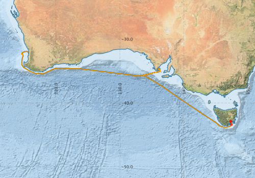
From: Hobart To: Fremantle
Region: Great Australian Bight and Bremer Sub-Basin.
Ship: Southern Surveyor [details]
Description:
MNF Southern Surveyor research voyage SS2013_t02.
The benthic fauna of the Great Australian Bight
Scientific Objectives:
The focus of this program is to give students a taste of what it is like to live and work on an ocean going research vessel and to expose them to some of the different sampling methods and equipment that are used in oceanographic research. The students will have three quasi scientific aims as follows: 1) to sample and characterise the benthic communities in the Great Australian Bight (GAB); 2) to investigate surface and water column productivity along Australia's southern seaboard; 3) to map Australia's seafloor. The students will be involved in all aspects of the research - sorting and curating the fauna - milking the rosette/changing the filters and measuring the dissolved oxygen and salinity - operating and monitoring the swath. Outside of sampling stations and designated tasks, students will take it in turns to watch for marine mammals and we may supplement the sampling and research with a series of lectures and practicals utilising the material/data collected.
For Keith, the voyage provides an ongoing opportunity to use vessel transit time to complete a national mapping of the upper-mid slope seabed with multi-beam mapping and associated ecological interpretation. The upper-slope and mid-slope seabed 100 m to 1500 m depth range, are regions important for regional marine planning, biodiversity and conservation assessments and fisheries habitat mapping. The swath mapping will be integrated as a part of the student activities and there is a 12h portion of the transit dedicated to targeting some canyons off Esperance and filling the swath track adjacent to the 500 m isobath.
For Tanner & Williams the voyage provides an opportunity to gain further specimens and add a temporal aspect to their study of the epifaunal assemblages (benthic) of the GAB Marine Park and its surrounds. The GAB is a unique ecosystem, with diversity similar to the Great Barrier Reef, and a much higher proportion of endemic species, but only a fraction of the scientific effort.
Leader: S. Holmes (USYD)
Project: National Facility External Users: S. Holmes (University of Sydney) [details]
- IMOS - AusCPR: Phytoplankton Abundance [details]
- IMOS - AusCPR: Phytoplankton and Zooplankton Abundance - Global Continuous Plankton dataset (GACs) [details]
- IMOS - AusCPR: Zooplankton Abundance [details]
- IMOS Bio-Acoustic Ships of Opportunity (BA SOOP) Sub-Facility [details]
- Southern Surveyor Voyage SS2013_T02 ADCP Data [details]
- Southern Surveyor Voyage SS2013_T02 Multibeam Echosounder Data [details]
- Southern Surveyor Voyage SS2013_T02 Raw Data Tapes and Documentation [details]
- Southern Surveyor Voyage SS2013_T02 Underway Data [details]
- IMOS - Phytoplankton Abundance and Biovolume (CPR), Australia (2007 to present)
- Download from OBIS Australia IPT
- View at - Ocean Biodiversity Information System (OBIS) Atlas of Living Australia (ALA) GBIF
- IMOS - Zooplankton Abundance and Biomass Index (CPR)
- Download from OBIS Australia IPT
- View at - Ocean Biodiversity Information System (OBIS) Atlas of Living Australia (ALA) GBIF
Participants - on ship:-
| Name | Role | Organisation |
|---|---|---|
| Alan Williams | Chief Scientist | CSIRO Marine and Atmospheric Research |
| Amber-Louise Burberry | Student - swath | University of Technology, Sydney |
| Anoosh Sarraf | MNF Computing support | CSIRO Marine and Atmospheric Research |
| Bethany Ellis | Student - swath | University of New South Wales - Centre for Marine Science |
| Brett Muir | Electronics support | CSIRO Marine and Atmospheric Research |
| Dagmar Kubistin | Piggy-back | University of Wollongong |
| Karen Gowlett-Holmes | Faunal identification & curation | CSIRO Marine and Atmospheric Research |
| Mark Lewis | Beam trawl support | CSIRO Marine and Atmospheric Research |
| Mark Rayner | MNF Hydrochemistry Support | CSIRO Marine and Atmospheric Research |
| Peter Fisher | Honours - student | University of Western Sydney |
| Rod Palmer | MNF Voyage Manager | CSIRO Marine and Atmospheric Research |
| Sabine Piller | 2nd watch leader | University of Western Australia |
| Shirley Sorokin | Faunal identification & curation | South Australian Research and Development Institute |
| Sian Bruce | Student | University of Technology, Sydney |
| Tony Veness | MNF Swath support | CSIRO Marine and Atmospheric Research |
This list includes those that may have only been on part of the voyage. See voyage reports on 'Reports and Maps' tab for details.
Marine National Facility Reports - plans, summaries and data processing
- SS2013_T02 Voyage Plan - includes objectives, investigator details, proposed data collection, voyage track and equipment to be used.
- SS2013_T02 Underway Data Processing Report - details of data processing steps, calibration information, instruments used and any issues with the data.
- SS2013_T02 Voyage Summary - includes preliminary results, voyage narrative, types of data collected with C77/ROSCOP codes.
- SS2013_T02 Scientific Highlight - report of the key outputs
-

Publications, reports and datasets from this voyage.
Dataset
- Bakker, Dorothee C E; Pfeil, Benjamin; Smith, Karl; Hankin, Steven; Olsen, Are; Alin, Simone R; Cosca, Catherine E; Harasawa, Sumiko; Kozyr, Alexander; Nojiri, Yukihiro; O'Brien, Kevin M; Schuster, Ute; Telszewski, Maciej; Tilbrook, Bronte; Wada, Chisato; Akl, John; Barbero, Leticia; Bates, Nicolas R; Boutin, Jacqueline; Bozec, Yann; Cai, Wei-Jun; Castle, Robert D; Chavez, Francisco P; Chen, Lei; Chierici, Melissa; Currie, Kim I; de Baar, Hein J W; Evans, Wiley; Feely, Richard A; Fransson, Agneta; Gao, Zhongyong; Hales, Burke; Hardman-Mountford, Nicolas J; Hoppema, Mario; Huang, Wei-Jen; Hunt, Christopher W; Huss, Betty; Ichikawa, Tadafumi; Johannessen, Truls; Jones, Elizabeth M; Jones, Steve D; Jutterstrøm, Sara; Kitidis, Vassilis; Körtzinger, Arne; Landschützer, Peter; Lauvset, Siv K; Lefèvre, Nathalie; Manke, Ansley; Mathis, Jeremy T; Merlivat, Liliane; Metzl, Nicolas; Murata, Akihiko; Newberger, Timothy; Omar, Abdirahman M; Ono, Tsuneo; Park, Geun-Ha; Paterson, Kristina; Pierrot, Denis; Ríos, Aida F; Sabine, Christopher L; Saito, Shu; Salisbury, Joe; Sarma, Vedula V S S; Schlitzer, Reiner; Sieger, Rainer; Skjelvan, Ingunn; Steinhoff, Tobias; Sullivan, Kevin; Sun, Heng; Sutton, Adrienne; Suzuki, Toru; Sweeney, Colm; Takahashi, Taro; Tjiputra, Jerry; Tsurushima, Nobuo; van Heuven, Steven; Vandemark, Doug; Vlahos, Penny; Wallace, Douglas WR; Wanninkhof, Rik; Watson, Andrew J (2014): Surface Ocean CO2 Atlas (SOCAT) V2. PANGAEA, 10.1594/PANGAEA.811776
- Smith, S. R.,Lopez, N.,Bourassa, M. A. (2016) SAMOS air‐sea fluxes: 2005–2014. Geoscience Data Journal 3 pp9-19. 10.1002/gdj3.34
DwC Archive
- IMOS - Phytoplankton Abundance and Biovolume (CPR), Australia (2007 to present) (Darwin Core Archive) External link to reference
- IMOS - Zooplankton Abundance and Biomass Index (CPR) (Darwin Core Archive) External link to reference
Journal Article
- Bukosa, Beata,Deutscher, Nicholas M.,Fisher, Jenny A.,Kubistin, Dagmar,Paton-Walsh, Clare,Griffith, David W. T. (2019) Simultaneous shipborne measurements of CO2, CH4 and CO and their application to improving greenhouse-gas flux estimates in Australia. Atmospheric Chemistry and Physics 19 pp7055-7072. 10.5194/acp-19-7055-2019
- Gustavo Hinestrosa, Jody M.Webster, Robin J. Beaman (2016) Postglacial sediment deposition along a mixed carbonate-siliciclastic margin: New constraints from the drowned shelf-edge reefs of the Great Barrier Reef, Australia. Palaeogeography, Palaeoclimatology, Palaeoecology Volume 446, 15 March 2016, Pages 168-185 10.1016/j.palaeo.2016.01.023
- McEnnulty, Felicity R.,Davies, Claire H.,Armstrong, Asia O,Atkins, Natalia,Coman, Frank,Clementson, Lesley,Edgar, Steven,Eriksen, Ruth S.,Everett, Jason D.,Anthony Koslow, J.,Lønborg, Christian,McKinnon, A. David,Miller, Margaret,O’Brien, Todd D.,Pausina, Sarah A.,Uribe-Palomino, Julian,Rochester, Wayne,Rothlisberg, Peter C.,Slotwinski, Anita,Strzelecki, Joanna (2020) A database of zooplankton biomass in Australian marine waters. Scientific Data 7 pp-. 10.1038/s41597-020-00625-9
Search for publications, reports and datasets from this and other voyages
Data publishing
This is a list of online datasets hosted by CSIRO. Other processed datasets hosted by collaborating organisations may be found on the 'Metadata' or "Reports, Publications and Maps' tab.
Use the Get data link on the right to extract data using the NCMI Data Trawler.
| Data Stream | Data Summary | Get data | ||||||||||||||
|---|---|---|---|---|---|---|---|---|---|---|---|---|---|---|---|---|
| ADCP Data |
|
|||||||||||||||
| Multibeam echosounder |
|
|||||||||||||||
| SOOP Bio-acoustics |
|
External link
Transect 2 - datafile at IMOS |
||||||||||||||
| Underway |
|
Deployments by start time:- Click on column header to sort. Use link on 'Deployment' to see full details. Use the CSV button at the bottom to export data (tab delimited).
Search for deployments from this voyage and others
| Deployment | Operation | Station | Cast | Gear | Project | Datetime | Start Location | End Location | Depth range | Max Depth | Description | |||
|---|---|---|---|---|---|---|---|---|---|---|---|---|---|---|
| Start | End | Lat | Lon | Lat | Lon | |||||||||
| ADCP Data [details] | RDI Ocean Surveyor Acoustic Doppler current profiler | 2369 | 2013-06-17 07:03 | 2013-06-28 20:13 | -42.8863 | 147.3385 | -31.9457 | 115.4787 | 813 | |||||
| Underway System [details] | Air Temperature Sensor-HMT333,Barometer,Doppler speed log,Fluorometer WS3S-443P,Gill Ultrasonic Wind Sensor,Gill Ultrasonic Wind Sensor,Humidity Sensor-HMT333,IMOS Port Pyranometer-SN 35122F3,IMOS Port Radiometer-SN 35111F3,IMOS Stbd Pyranometer-SN 35123F3,IMOS Stbd Radiometer-SN 35093F3,IMOS rain gauge,IMOS rain gauge,Licor - LI-190SL Q46072,RM Young 05106 wind monitor-75621,RM Young 05106 wind monitor-75621,RM Young 05106 wind monitor-75621,RM Young Rain Gauge,Seapath 200,Seapath 200,Seapath 200,Simrad EK60 echosounder,ThermoSalinoGraph (TSG)-SN 2753,ThermoSalinoGraph (TSG)-SN 2753 | 2369 | 2013-06-17 08:24 | 2013-06-28 23:38 | -42.8863 | 147.3385 | -32.0516 | 115.7432 | ||||||
| Multibeam echosounder [details] | EM300 Multibeam Echosounder | 2013-06-17 12:30 | 2013-06-28 22:46 | -43.3910 | 147.4649 | -31.9990 | 115.6840 | 5615 | ||||||