Voyage details and related metadata, reports, events and data.
SS2012_V07
- is a Marine National Facility ![]() voyage
voyage
Title: Tasmantid Seamounts: volcanic, tectonic, and carbonate record
Period: 2012-11-23 08:00 to 2012-12-19 03:00 UTC
Duration: 25.79 days
From: Brisbane To: Brisbane
Region: Queensland coast, Tasmantid Seamounts.
Ship: Southern Surveyor [details]
Description: Southern Surveyor SS2012_V07. Tasmantid Seamounts: volcanic, tectonic, and carbonate record. Scientific Objectives : The Tasmantid seamounts are a chain of underwater hotspot-derived intraplate volcanoes situated 150 to 600 km east of the Australian mainland (Figure 1). Because of the long record of hotspot-derived volcanic activity - spanning more than 2000 km and >40 million years - the seamounts provide an exceptional and largely untapped record of Australian plate velocity. Deciphering this record by obtaining volcanic samples suitable for high-resolution 40Ar/39Ar geochronology is a major objective of this expedition (Cohen, Vasconcelos, Knesel). Such volcanic samples will also record the chemical evolution of a long-lived mantle plume, and chemical analyses will reveal information on mantle reservoirs, melting, magma diversification, and the contrasting contamination effects of thinned continental lithosphere in the north versus oceanic lithosphere in the south (Knesel, Arculus). Geophysical data will also be collected over the seamounts and oceanic crust of the Tasman Sea to help study the tectonic history and lithospheric structure of the region. The larger seamounts are variably capped by fossil and modern coral reefs and/or other carbonate sediments (Webb). Although not targeted specifically, where carbonate materials are recovered with the volcanic rocks this material will provide a key biologic and climatic record of the seas east of Australia. Morphologic analysis of the seamounts will allow identification of volcanic and coral-growth geomorphology, as well as any mass wasting deposits (Cohen, Webb).
Leader: B. Cohen (UQ)
Project: National Facility External Users: B. Cohen (University of Queensland) [details]
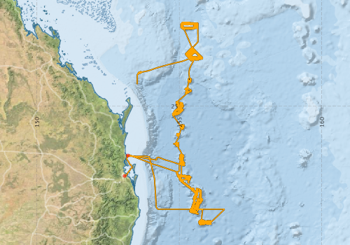
Voyage extents: 29° 09.6' S to 22° 03.3' S 153° 04.7' E to 156° 34.8' E Get voyage track shapefile Get CSV
Marlin Metadata:-
Metadata from OBIS Australia datasets:- biological data is published via the OBIS-AU IPT server and delivered to one or more of OBIS, ALA and GBIF
Download from OBIS Australia IPT View at - Ocean Biodiversity Information System (OBIS)
Participants - on ship:-
| Name | Role | Organisation |
|---|---|---|
| Abbas Babaahmadi | Petrology/Geophysics | University of Queensland |
| Anoosh Sarraf | MNF Computing Support | CSIRO Marine and Atmospheric Research |
| Beatriz Pruina | Igneous Petrology | University of Queensland |
| Benjamin Cohen | Chief Scientist | University of Queensland |
| Gregory Webb | Carbonates | University of Queensland |
| Ian Fortes | Igneous Petrology | University of Queensland |
| James Sadler | Carbonates | University of Queensland |
| Lara Kalnins | Geophysics | University of Oxford |
| Lisa Woodward | MNF Voyage manager | CSIRO Marine and Atmospheric Research |
| Rebecca Norman | Petrology | Australian National University |
| Rod Palmer | MNF Electronics Support | CSIRO Marine and Atmospheric Research |
| Tara Martin | MNF Swath Mapping | CSIRO Marine and Atmospheric Research |
| Toby Cunningham | Igneous Petrology | University of Queensland |
| Tracey Crossingham | Igneous Petrology | University of Queensland |
Participants - shore based:-
| Name | Role | Organisation | Project |
|---|---|---|---|
| Kurt Knesel | University of Queensland | ||
| Paulo Vasconcelos | University of Queensland | ||
| Richard Arculus | Australian National University - Research School of Earth Sciences |
This list includes those that may have only been on part of the voyage. See voyage reports on 'Reports and Maps' tab for details.
Marine National Facility Reports - plans, summaries and data processing
-
SS2012_V07 Voyage Plan
- includes objectives, investigator details, proposed data collection, voyage track and equipment to be used.
-
SS2012_V07 Underway Data Processing Report
- details of data processing steps, calibration information, instruments used and any issues with the data.
-
SS2012_V07 Voyage Summary
- includes preliminary results, voyage narrative, types of data collected with C77/ROSCOP codes.
-
SS2012_V07 Scientific Highlight
- report of the key outputs
-

Publications, reports and datasets from this voyage.
Conference abstract
- Gagen E.J., Monteiro H.S., Northdurft L.D., Rintoul L., Paterson D., Vasconcelos P.M., Webb G.E., Southam G. (2016) Trace metal distribution in iron manganese oxihydroxide crusts from a Tasmantid Seamount. Goldschmidt Conference,Yokohama, Japan
Dataset
- Cohen, Benjamin; Yule, Christopher; Navidad, Cisco; Kalnins, Lara; Marine National Facility (2021): AusSeabed:Tasmantid Seamounts Bathymetry 32m - 64m (CSIRO) ss2012_v07. v2. CSIRO. Data Collection. 10.25919/0d2p-ys49
- Smith, S. R.,Lopez, N.,Bourassa, M. A. (2016) SAMOS air‐sea fluxes: 2005–2014. Geoscience Data Journal 3 pp9-19. 10.1002/gdj3.34
IPT Resource
- First records of Hamacantha species from seamounts off eastern Australia (Porifera, Demospongiae, Merliida), with description of four new species (Darwin Core Archive) External link to reference
Journal Article
- Crossingham, Tracey J.,Vasconcelos, Paulo M.,Cunningham, Toby,Knesel, Kurt M. (2017) 40Ar/39Ar geochronology and volume estimates of the Tasmantid Seamounts: Support for a change in the motion of the Australian plate. Journal of Volcanology and Geothermal Research 343 pp95-108. 10.1016/j.jvolgeores.2017.06.014
- Ekins, Merrick,Baker, Soraya,Hooper, John N.A. (2023) First records of Hamacantha species from seamounts off eastern Australia (Porifera, Demospongiae, Merliida), with description of four new species. Zootaxa 5318 pp382-400. 10.11646/zootaxa.5318.3.4
- Grun, Tobias B.,Mihaljevic, Morana,Webb, Gregory E. (2020) Comparative taphonomy of deep-sea and shallow-marine echinoids of the genus Echinocyamus. Palaios 35 pp403-420. 10.2110/palo.2019.024
- Johnson, Alysha M.,Dickson, Mark E.,Hamylton, Sarah,Woodroffe, Colin D. (2025) The geomorphic evolution of the Tasmantid Seamount Chain. Marine Geology 486 pp107560-. 10.1016/j.margeo.2025.107560
- Kalnins, Lara; Richards, Frederick; Watts, Anthony; Cohen, Benjamin; Beaman, Robin. (2018). The Morphology of the Tasmantid Seamounts: Interactions Between Tectonic Inheritance and Magmatic Evolution. University of Edinburgh. School of GeoSciences 10.7488/ds/2430
- Lucieer, Vanessa,Flukes, Emma,Monk, Jacquomo,Walsh, Peter (2024) Geomorphometric maps of Australia’s Marine Park estate and their role in improving the integrated monitoring and management of marine ecosystems. Frontiers in Marine Science 10 pp-. 10.3389/fmars.2023.1302108
- Mather, Ben R.,Müller, R. Dietmar,Seton, Maria,Ruttor, Saskia,Nebel, Oliver,Mortimer, Nick (2020) Intraplate volcanism triggered by bursts in slab flux. Science Advances 6 ppeabd0953-. 10.1126/sciadv.abd0953
- Richards, F. D.,Kalnins, L. M.,Watts, A. B.,Cohen, B. E.,Beaman, R. J. (2018) The Morphology of the Tasmantid Seamounts: Interactions Between Tectonic Inheritance and Magmatic Evolution. Geochemistry, Geophysics, Geosystems 19 pp3870-3891. 10.1029/2018GC007821
- Ruttor, Saskia,Nebel, Oliver,Nebel-Yacobsen, Yona,Cohen, Benjamin E.,Eggins, Stephen (2021) Alkalinity of ocean island lavas decoupled from enriched source components: A case study from the EM1-PREMA Tasmantid mantle plume. Geochimica et Cosmochimica Acta 314 pp140-158. 10.1016/j.gca.2021.09.023
Search for publications, reports and datasets from this and other voyages
Data publishing
This is a list of online datasets hosted by CSIRO. Other processed datasets hosted by collaborating organisations may be found on the 'Metadata' or "Reports, Publications and Maps' tab.
Use the Get data link on the right to extract data using the NCMI Data Trawler.
| Data Stream | Data Summary | Get data | ||||||||||||
|---|---|---|---|---|---|---|---|---|---|---|---|---|---|---|
| Marine biodiversity observations and/or samples |
|
Get Data from Trawler |
||||||||||||
| Multibeam echosounder |
|
Get Data from Trawler |
||||||||||||
| Underway |
|
Get Data from Trawler Download 5 sec NetCDF dataset ss2012_v07UWYnc.zip |
Deployments by start time:- Click on column header to sort. Use link on 'Deployment' to see full details. Use the CSV button at the bottom to export data (tab delimited).
Search for deployments from this voyage and others
| Deployment | Operation | Station | Cast | Gear | Project | Start and end times | Start Location | End Location | Depth range | Max Depth | Description | |||
|---|---|---|---|---|---|---|---|---|---|---|---|---|---|---|
| Underway System [details] | Air Temperature Sensor-HMT333,Barometer,Doppler speed log,Fluorometer WS3S-1203,Gill Ultrasonic Wind Sensor,Gill Ultrasonic Wind Sensor,Humidity Sensor-HMT333,IMOS Port Pyranometer-SN 35122F3,IMOS Port Radiometer-SN 35111F3,IMOS Stbd Pyranometer-SN 35123F3,IMOS Stbd Radiometer-SN 35093F3,IMOS rain gauge,IMOS rain gauge,Licor - LI-190SL Q46071,RM Young 05106 wind monitor-75621,RM Young 05106 wind monitor-75621,RM Young 05106 wind monitor-75621,RM Young Rain Gauge,Remote Temperature (T)-SN 2621,Seapath 200,Seapath 200,Seapath 200,Simrad EK60 echosounder,ThermoSalinoGraph (TSG)-SS-SN 1777 | 2408 | 2012-11-23 05:58 | 2012-12-19 00:30 | -27.4469 | 153.0782 | -27.4384 | 153.1135 | ||||||
| Multibeam echosounder [details] | EM300 Multibeam Echosounder | 2012-11-23 11:53 | 2012-12-18 18:57 | -26.7309 | 153.1923 | -26.7139 | 153.1905 | 5106.2 | ||||||