Voyage details and related metadata, reports, events and data.
SS2012_T06
- is a Marine National Facility ![]() voyage
voyage
Period: 2012-09-07 00:00 to 2012-09-15 22:30 UTC
Duration: 8.94 days
From: Fremantle To: Darwin
Region: West Australian coast, Timor sea
Ship: Southern Surveyor [details]
Description: MNF Southern Surveyor research voyage SS2012_t06. Marine debris distribution in the Eastern Indian Ocean and Timor Sea. Scientific Objectives Marine Debris Surveys (Chris Wilcox,CMAR) We plan to address the following questions: 1.What is the density of marine debris in the oceanic regions around Australia? 2.What is the composition of marine debris in the regions sampled? 3.What fraction is anthropogenic in origin? We also hope to evaluate the use of an aerostat as a tool for collecting low level aerial images from behind the vessel. However this is conditional on further development of the appropriate camera with our technological collaborator. Plankton Surveys (Dave McLeod, CMAR) To collect plankton using a CPR along a transect between Broome and Darwin to improve our understanding of plankton abundance and distribution in the north west area of Australia. Measurements of Nitrogen Fixation (Eric Raes, UWA) Collect physical and biological data using the ship's conductivity - temperature - depth profiler from the surface and the oxygen minimum feature in the photic zone at stations between Broome and Darwin, particularly targeting eddies where possible.
Leader: C. Wilcox (CMAR)
Project: Marine debris distribution in the Eastern Indian Ocean and Timor Sea. [details]
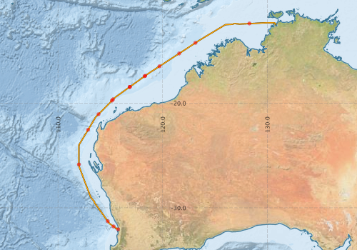
Voyage extents: 32° 03.5' S to 12° 19.0' S 112° 00.0' E to 130° 50.9' E Get voyage track shapefile Get CSV
Marlin Metadata:-
Metadata from OBIS Australia datasets:- biological data is published via the OBIS-AU IPT server and delivered to one or more of OBIS, ALA and GBIF
Download from OBIS Australia IPT View at - Ocean Biodiversity Information System (OBIS)
Participants - on ship:-
| Name | Role | Organisation |
|---|---|---|
| Allison McInnes | Nitrogen study team member | University of Western Australia |
| Anoosh Sarraf | MNF Computing Support | CSIRO Marine and Atmospheric Research |
| Chris Wilcox | Chief Scientist | CSIRO Marine and Atmospheric Research |
| David McLeod | Plankton Study Technician | CSIRO Marine and Atmospheric Research |
| Eric Raes | Nitrogen study team leader | University of Western Australia |
| Hannipoula Olsen | Nitrogen study team member | UWA/Texas University |
| Karl Forcey | MNF Electronics Support | CSIRO Marine and Atmospheric Research |
| Peter Hoskin | Marine debris team member | Earthwatch |
| Ray Cilia | Marine debris team member | Earthwatch |
| Rebecca Hall | Marine debris team member | Earthwatch |
| Sascha Frydman | MNF Voyage Manager | CSIRO Marine and Atmospheric Research |
This list includes those that may have only been on part of the voyage. See voyage reports on 'Reports and Maps' tab for details.
Marine National Facility Reports - plans, summaries and data processing
-
SS2012_T06 Scientific Highlight
- report of the key outputs
-
SS2012_T06 Underway Data Processing Report
- details of data processing steps, calibration information, instruments used and any issues with the data.
-
SS2012_T06 Voyage Summary
- includes preliminary results, voyage narrative, types of data collected with C77/ROSCOP codes.
-
SS2012_T06 Voyage Plan
- includes objectives, investigator details, proposed data collection, voyage track and equipment to be used.
-

Publications, reports and datasets from this voyage.
Dataset
- Bioplatforms Data Portal External link to reference
- Raes, Eric J; Bodrossy, Levente; Van De Kamp, Jodie; Bissett, Andrew; Waite, Anya M (2017): 16S - Bacterial OTU community structure in surface waters in the eastern Indian Ocean, part 2. PANGAEA. 10.1594/PANGAEA.882509
- Raes, Eric J; Bodrossy, Levente; Van De Kamp, Jodie; Bissett, Andrew; Waite, Anya M (2017): Physical and biochemical data and N2-fixation rates in surface waters in the eastern Indian Ocean. PANGAEA 10.1594/PANGAEA.882506
- Raes, Eric J; Bodrossy, Levente; Van De Kamp, Jodie; Bissett, Andrew; Waite, Anya M (2017): nifH_OTU microbial community structure in surface waters in the eastern Indian Ocean. PANGAEA 10.1594/PANGAEA.882510
- Smith, S. R.,Lopez, N.,Bourassa, M. A. (2016) SAMOS air‐sea fluxes: 2005–2014. Geoscience Data Journal 3 pp9-19. 10.1002/gdj3.34
IPT Resource
- Marine Microbes from RV Southern Surveyor voyage SS2012_T06, Australia (2012) (Darwin Core Archive) External link to reference
Journal Article
- Baldry, Kimberlee,Johnson, Robert,Strutton, Peter G.,Boyd, Philip W. (2024) A biological ocean data reformatting effort. Scientific Data 11 pp-. 10.1038/s41597-024-03038-0
- Eric J. Raes , Levente Bodrossy, Jodie van de Kamp, Andrew Bissett, Anya M. Waite (2017) Marine bacterial richness increases towards higher latitudes in the eastern Indian Ocean Limnology and Oceanography Letters 3, 2017, 10–19 10.1002/lol2.10058
- Raes, EJ,Waite, AM,McInnes, AS,Olsen, H,Nguyen, HM,Hardman-Mountford, N,Thompson, PA (2014) Changes in latitude and dominant diazotrophic community alter N2 fixation. Marine Ecology Progress Series 516 pp85-102. 10.3354/meps11009
- Raes, Eric J.,Bodrossy, Levente,Van de Kamp, Jodie,Holmes, Bronwyn,Hardman-Mountford, Nick (2016) Reduction of the Powerful Greenhouse Gas N2O in the South-Eastern Indian Ocean. PLOS ONE 11 ppe0145996-. 10.1371/journal.pone.0145996
Search for publications, reports and datasets from this and other voyages
Data publishing
This is a list of online datasets hosted by CSIRO. Other processed datasets hosted by collaborating organisations may be found on the 'Metadata' or "Reports, Publications and Maps' tab.
Use the Get data link on the right to extract data using the NCMI Data Trawler.
| Data Stream | Data Summary | Get data | ||||||||||||||
|---|---|---|---|---|---|---|---|---|---|---|---|---|---|---|---|---|
| ADCP Data |
|
Get Data from Trawler Download NetCDF ss2012_t06_ADCP_nc.zip Overview ADCP Dataset HTML Download Processing Report ss2012_t06ADCP.pdf |
||||||||||||||
| Marine biodiversity observations and/or samples |
|
Get Data from Trawler |
||||||||||||||
| CTD profile |
|
Get Data from Trawler Processing report: ss2012_t06_CTD.pdf Download NetCDF data ss2012_t06_CTD_avg_nc.zip Download CTD plots ss2012_t06_CTD_profile_plots_pdf.zip |
||||||||||||||
| Multibeam echosounder |
|
Get Data from Trawler |
||||||||||||||
| Underway |
|
Get Data from Trawler Download 5 sec NetCDF dataset ss2012_t06UWYnc.zip |
||||||||||||||
| XBT Profile |
|
Get Data from Trawler Download xbt_ascii_ma_2007_2012.zip (MEDS ASCII format ) Download xbt_nc_ss2007_2012.zip (NetCDF format) |
Deployments by start time:- Click on column header to sort. Use link on 'Deployment' to see full details. Use the CSV button at the bottom to export data (tab delimited).
Search for deployments from this voyage and others
| Deployment | Operation | Station | Cast | Gear | Project | Start and end times | Start Location | End Location | Depth range | Max Depth | Description | |||
|---|---|---|---|---|---|---|---|---|---|---|---|---|---|---|
| Underway System [details] | Air Temperature Sensor-HMT333,Barometer,Doppler speed log,Fluorometer WS3S-1203,Gill Ultrasonic Wind Sensor,Gill Ultrasonic Wind Sensor,Humidity Sensor-HMT333,IMOS Port Pyranometer-SN 35122F3,IMOS Port Radiometer-SN 35111F3,IMOS Stbd Pyranometer-SN 35123F3,IMOS Stbd Radiometer-SN 35093F3,IMOS rain gauge,IMOS rain gauge,Licor - LI-190SL Q46071,RM Young 05106 wind monitor-75621,RM Young 05106 wind monitor-75621,RM Young 05106 wind monitor-75621,RM Young Rain Gauge,Remote Temperature (T)-SN 2621,Seapath 200,Seapath 200,Seapath 200,Simrad EK60 echosounder,ThermoSalinoGraph (TSG)-SS-SN 1777 | 2402 | 2012-09-07 01:11 | 2012-09-16 00:46 | -32.0496 | 115.7452 | -12.4709 | 130.8489 | ||||||
| ADCP Data [details] | RDI Ocean Surveyor Acoustic Doppler current profiler | 2402 | 2012-09-07 03:10 | 2012-09-15 21:51 | -31.7800 | 115.3094 | -12.3938 | 130.7573 | 653.5 | |||||
| Multibeam echosounder [details] | EM300 Multibeam Echosounder | 2012-09-07 09:08 | 2012-09-15 22:51 | -31.2778 | 114.7564 | -12.3938 | 130.7573 | 4251.5 | ||||||
| XBT Cast [details] | Sippican Deep Blue | 2391 | 2012-09-09 01:35 | -25.8626 | 112.0001 | 1100.3 | ||||||||
| XBT Cast [details] | Sippican Deep Blue | 2391 | 2012-09-10 01:07 | -22.5365 | 112.8797 | 1100.3 | ||||||||
| XBT Cast [details] | Sippican Deep Blue | 2391 | 2012-09-10 13:13 | -21.0585 | 113.8707 | 1100.3 | ||||||||
| CTD Cast [details] | 2 | Cast 2 | CTD 21,Conductivity CTD 21 - SN 3309,Oxygen CTD 21-SBE 43-SN 1794,Pressure CTD 21,Temperature CTD 21 - SN 5422 | 2402 | 2012-09-11 01:19 | 2012-09-11 02:03 | -19.7633 | 115.1465 | -19.7618 | 115.1448 | 501 | |||
| XBT Cast [details] | Sippican Deep Blue | 2391 | 2012-09-11 03:11 | -19.6314 | 115.2597 | 1100.3 | ||||||||
| XBT Cast [details] | Sippican Deep Blue | 2391 | 2012-09-11 15:11 | -18.4530 | 116.8496 | 371.5 | ||||||||
| XBT Cast [details] | Sippican Deep Blue | 2391 | 2012-09-11 15:22 | -18.4441 | 116.8619 | 1100.3 | ||||||||
| XBT Cast [details] | Sippican Deep Blue | 2391 | 2012-09-12 01:46 | -17.4245 | 118.2815 | 993.2 | ||||||||
| XBT Cast [details] | Sippican Deep Blue | 2391 | 2012-09-12 02:09 | -17.3844 | 118.3373 | 1100.3 | ||||||||
| XBT Cast [details] | Sippican Deep Blue | 2391 | 2012-09-12 11:43 | -16.4784 | 119.7024 | 1100.3 | ||||||||
| XBT Cast [details] | Sippican Deep Blue | 2391 | 2012-09-13 01:18 | -15.2540 | 121.5840 | 1100.3 | ||||||||
| XBT Cast [details] | Sippican Deep Blue | 2391 | 2012-09-13 11:54 | -14.2427 | 123.1297 | 1100.3 | ||||||||
| CTD Cast [details] | 3 | Cast 3 | CTD 21,Conductivity CTD 21 - SN 3309,Oxygen CTD 21-SBE 43-SN 1794,Pressure CTD 21,Temperature CTD 21 - SN 5422 | 2402 | 2012-09-14 22:48 | 2012-09-14 22:55 | -12.3850 | 128.2926 | -12.3840 | 128.2918 | 90 | |||