Voyage details and related metadata, reports, events and data.
SS2011_V06
- is a Marine National Facility ![]() voyage
voyage
Period: 2011-10-20 08:00 to 2011-11-09 00:00 UTC
Duration: 19.67 days
From: Fremantle To: Fremantle
Region: Perth Abyssal Plain, offshore southwest Australia
Ship: Southern Surveyor [details]
Description: Southern Surveyor Research Voyage ss2011_v06. The Perth Abyssal Plain: Understanding Eastern Gondwana Break-up Scientific Objectives The objectives of this voyage are to investigate; 1. The crustal nature of the Gulden Draak Ridge, Batavia Knoll, and Dirck Hartog ridge -continental and/or volcanic - in order to further constrain plate tectonic models of the early separation between India and Australia and also to understand the interaction between the seafloor-spreading system and volcanism related to theKerguelen hotspot. This objective relates primarily to Nathan Daczko and Jacqueline Halpin. 2. The age and formation history of the 'de Gonneville Triangle'. This piece of oceanic crust is located at what was the triple junction of rifting between Australia-India-Antarctica. Understanding the de Gonneville Triangle is especially important because prior to Australia-Antarctic break-up it was immediately adjacent to the Enderby Basin, and the two basins should reveal the same magnetic anomaly patterns but current interpretations reveal considerable discrepancies. This objective relates primarily to Joanne Whittaker, Dietmar Müller and Simon Williams. 3. The age distribution of oceanic crust across both the east and west Perth Abyssal Plain.Acquiring ridge-perpendicular magnetic anomaly profiles are crucial in order to constrain the early spreading history between India and Australia and the prebreakup fit between India-Antarctica and Australia. Of particular importance is the oceanic crust located southwest of the Dirck Hartog Ridge. Sampling in the Perth Abyssal Plain region will help to resolve uncertainties regarding the early spreading history and the full-fit of the India-Australia-Antarctica triple plate system. This objective relates primarily to Joanne Whittaker, Dietmar Müller and Simon Williams. Taken from Voyage plan, please read plan for full details.
Leader: S. Williams (USYD)
Project: National Facility External Users: S. Williams (University of Sydney) [details]
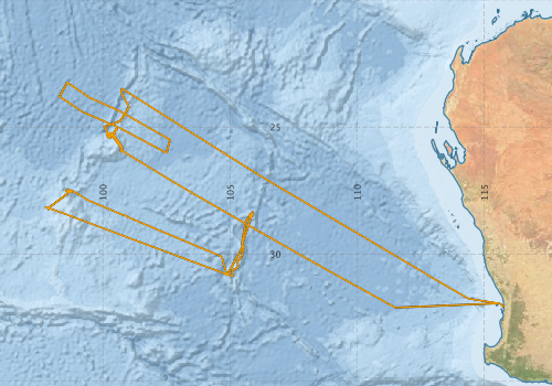
Voyage extents: 32° 01.9' S to 23° 15.2' S 97° 44.8' E to 115° 41.2' E Get voyage track shapefile Get CSV
Marlin Metadata:-
Participants - on ship:-
| Name | Role | Organisation |
|---|---|---|
| Adrien Bronner | Continental margin tectonics student | Institut de Physique du Globe Strasbourg |
| Aedon Talsma | Tectonics student | University of Sydney |
| Don McKenzie | MNF Voyage Manager | CSIRO Oceans & Atmosphere - Hobart |
| Drew Mills | MNF Electronics Support | CSIRO Oceans & Atmosphere - Hobart |
| Hugh Barker | MNF Computing Support | CSIRO Oceans & Atmosphere - Hobart |
| Jack Healy | Magnetics student | University of Sydney |
| Jacqueline Halpin | Geochemical/geochronology scientist | University of Sydney |
| Madeline Kobler | Geochemical/geochronology student | Macquarie University |
| Nathan Butterworth | Tectonics student | University of Sydney |
| Nathan Dazko | Geochemical/geochronology scientist | Macquarie University |
| Robyn Gardner | Geochemical/geochronology student | Macquarie University |
| Roi Granot | Magnetics/tectonics scientist | Ben-Gurion University, Israel |
| Simon Williams | Chief Scientist (tectonics/magnetics scientist | University of Sydney |
| Tara Martin | MNF Swath Support | CSIRO Oceans & Atmosphere - Hobart |
| Zohar Ehrlich | Magnetics/tectonics student | Ben-Gurion University, Israel |
This list includes those that may have only been on part of the voyage. See voyage reports on 'Reports and Maps' tab for details.
Marine National Facility Reports - plans, summaries and data processing
-
SS2011_V06 Scientific Highlight
- report of the key outputs
-
SS2011_V06 Underway Data Processing Report
- details of data processing steps, calibration information, instruments used and any issues with the data.
-
SS2011_V06 Voyage Summary
- includes preliminary results, voyage narrative, types of data collected with C77/ROSCOP codes.
-
SS2011_V06 Voyage Plan
- includes objectives, investigator details, proposed data collection, voyage track and equipment to be used.
-

Publications, reports and datasets from this voyage.
Book Chapter
- Whittaker, J. M., Halpin, J. A., Williams, S. E., Hall, L. S., Gardner, R., Kobler, M. E., Müller, R. D. (2013), Tectonic evolution and continental fragmentation of the southern West Australian margin. In M. Keep, & S. J. Moss (Eds.), West Australian Basins Symposium 2013 proceedings, Perth, WA: Petroleum Exploration Society of Australia. pp. 1-18. External link to reference
- Williams S.E., Whittaker J.M, Müller et al. 2013. Newly recognised continental fragments rifted from the West Australian margin, in Keep, M. and Moss, S.J. (eds) The Sedimentary Basins of Western Australia IV.
Conference paper
- Whittaker, J., Halpin, J., Williams, S., Hall, L., Gardner, R., Kobler, M., Daczko, N., & Müller, D. (2013), Tectonic Evolution and Continental Fragmentation of the Southern West Australian Margin. The Sedimentary Basins of Western Australia IV, Perth, WA, 18-21 August 2013. Proceedings of the Petroleum Exploration Society of Australia Symposium, pp. 18. 10.1.1.655.9860
- Williams, SE and Whittaker, J and Muller, RD. (2013), Newly-recognised Continental Fragments Rifted from the West Australian Margin, The Sedimentary Basins of Western Australia IV: Proceedings of the Petroleum Exploration Society of Australia Symposium, 18-21 August 2013, Perth, WA, pp. 1-9.
Dataset
- Asimus, J., & Halpin, J. (2025). Data appendices for: Kerguelen Plateau: Interplay between a mantle plume, microcontinents and ocean spreading ridges [Data set]. Institute for Marine and Antarctic Studies. 10.25959/Q88B-4S29
- Smith, S. R.,Lopez, N.,Bourassa, M. A. (2016) SAMOS air‐sea fluxes: 2005–2014. Geoscience Data Journal 3 pp9-19. 10.1002/gdj3.34
- Whittaker, J., Halpin, J., Daczkop, N. and Williams, S. (2011) Dredge Samples from SS2011_V06 External link to reference
Journal Article
- Daczko, Nathan R.,Halpin, Jacqueline A.,Fitzsimons, Ian C. W.,Whittaker, Joanne M. (2018) A cryptic Gondwana-forming orogen located in Antarctica. Scientific Reports 8 pp-. 10.1038/s41598-018-26530-1
- Gardner, Robyn L.,Daczko, Nathan R.,Halpin, Jacqueline A.,Whittaker, Joanne M. (2015) Discovery of a microcontinent (Gulden Draak Knoll) offshore Western Australia: Implications for East Gondwana reconstructions. Gondwana Research 28 pp1019-1031. 10.1016/j.gr.2014.08.013
- Jacqueline A. Halpin, Nathan R. Daczko, Madeline E. Kobler, Joanne M.Whittaker (2017) Strike-slip tectonics during the Neoproterozoic–Cambrian assembly of East Gondwana: Evidence from a newly discovered microcontinent in the Indian Ocean (Batavia Knoll) Gondwana Research Volume 51, November 2017, Pages 137-148 10.1016/j.gr.2017.08.002
- Maciag, L., Zawadzki, D., Kozub-Budzyn, G A., Piestrzynski, A., Kotlinski, R A., Wróbel, R J. (2019) Mineralogy of Cobalt-Rich Ferromanganese Crusts from the Perth Abyssal Plain (E Indian Ocean), Minerals 9(2) pp 84. 10.3390/min9020084
- Watson, S.J.,Whittaker, J.M.,Halpin, J.A.,Williams, S.E.,Milan, L.A.,Daczko, N.R.,Wyman, D.A. (2016) Tectonic drivers and the influence of the Kerguelen plume on seafloor spreading during formation of the early Indian Ocean. Gondwana Research 35 pp97-114. 10.1016/j.gr.2016.03.009
- Whittaker, Halpin, Williams, Hall, Gardner, Kobler, Daczko, et al. (2013) Tectonic evolution and continental fragmentation of the southern West Australian margin. Perth, WA: Petroleum Exploration Society of Australia, 2013.
External link to reference
- Whittaker, J.M.,Williams, S.E.,Halpin, J.A.,Wild, T.J.,Stilwell, J.D.,Jourdan, F.,Daczko, N.R. (2016) Eastern Indian Ocean microcontinent formation driven by plate motion changes. Earth and Planetary Science Letters 454 pp203-212. 10.1016/j.epsl.2016.09.019
- Wild, T J., Stilwell, J D. (2019) Palaeobiogeographic and tectonic significance of mid-Cretaceous invertebrate taxa from Batavia Knoll, eastern Indian Ocean. Palaeogeography, Palaeoclimatology, Palaeoecology, 522, pp 89-97. 10.1016/j.palaeo.2019.03.014
- Wild, Toban J.,Stilwell, Jeffrey D. (2016) First Cretaceous (Albian) invertebrate fossil assemblage from Batavia Knoll, Perth Abyssal Plain, eastern Indian Ocean: taxonomy and paleoecological significance. Journal of Paleontology 90 pp959-980. 10.1017/jpa.2016.76
- Williams, Simon E.,Whittaker, Joanne M.,Granot, Roi,Müller, Dietmar R. (2013) Early India-Australia spreading history revealed by newly detected Mesozoic magnetic anomalies in the Perth Abyssal Plain. Journal of Geophysical Research: Solid Earth 118 pp3275-3284. 10.1002/jgrb.50239
- Zawadzki, D., Maciag, L., Kotlinski, R A., Kozub-Budzyn, G A., Piestrzynski, A., Wróbel, R. (2018) 'Geochemistry of cobalt-rich ferromanganese crusts from the Perth Abyssal Plain (E Indian Ocean)', Ore Geology Reviews, Volume 101, pp 520-531. 10.1016/j.oregeorev.2018.08.004
Project
- P. Wessel (SOEST, U of Hawaii) and R. D. Müller (U of Sydney) Collaborators: D. T. Sandwell and S. C. Cande (Scripps Institution of Oceanography), 'The Global Seafloor Fabric and Magnetic Lineation Data Base Project' External link to reference
Thesis
- Watson S. (2018) Bathymetric and tectonic consequences of plume interaction with the ocean floor, PhD thesis, University of Tasmania
- Wild (2019) Keystones in East Gondwana breakup: provenance and palaeontology of sedimentary strata from East Indiaman Ridge, eastern Indian Ocean, PhD Thesis, Monash University.
Search for publications, reports and datasets from this and other voyages
Data publishing
This is a list of online datasets hosted by CSIRO. Other processed datasets hosted by collaborating organisations may be found on the 'Metadata' or "Reports, Publications and Maps' tab.
Use the Get data link on the right to extract data using the NCMI Data Trawler.
| Data Stream | Data Summary | Get data | ||||||||||||||
|---|---|---|---|---|---|---|---|---|---|---|---|---|---|---|---|---|
| ADCP Data |
|
Get Data from Trawler Download NetCDFss2011_v06_ADCP_long_nc.zip Download Processing Report ss2011_v06ADCP.pdf Download NetCDFss2011_v06_ADCP_short_nc.zip Overview ADCP Dataset HTML |
||||||||||||||
| Multibeam echosounder |
|
Get Data from Trawler |
||||||||||||||
| SOOP Bio-acoustics |
|
External link
Transect 2 - datafile at IMOS NetCDF Data Format: Manual Download |
||||||||||||||
| Underway |
|
Get Data from Trawler Download 5 sec NetCDF dataset ss2011_v06UWYnc.zip |
||||||||||||||
| XBT Profile |
|
Get Data from Trawler Download xbt_ascii_ma_2007_2012.zip (MEDS ASCII format ) Download xbt_nc_ss2007_2012.zip (NetCDF format) |
Deployments by start time:- Click on column header to sort. Use link on 'Deployment' to see full details. Use the CSV button at the bottom to export data (tab delimited).
Search for deployments from this voyage and others
| Deployment | Operation | Station | Cast | Gear | Project | Start and end times | Start Location | End Location | Depth range | Max Depth | Description | |||
|---|---|---|---|---|---|---|---|---|---|---|---|---|---|---|
| Underway System [details] | Air Temperature Sensor-HMT333,Barometer,Doppler speed log,Fluorometer WS3S-1203,Gill Ultrasonic Wind Sensor,Gill Ultrasonic Wind Sensor,Humidity Sensor-HMT333,IMOS Port Pyranometer-SN 35122F3,IMOS Port Radiometer-SN 35111F3,IMOS Stbd Pyranometer-SN 35123F3,IMOS Stbd Radiometer-SN 35093F3,IMOS rain gauge,IMOS rain gauge,Licor-UWQ 3708,RM Young 05106 wind monitor-75621,RM Young 05106 wind monitor-75621,RM Young 05106 wind monitor-75621,RM Young Rain Gauge,Remote Temperature (T)-SN 2621,Seapath 200,Seapath 200,Seapath 200,Simrad EK60 echosounder,ThermoSalinoGraph (TSG)-SS-SN 1777 | 2388 | 2011-10-20 07:24 | 2011-11-08 23:50 | -32.0547 | 115.7321 | -32.0445 | 115.7500 | ||||||
| Multibeam echosounder [details] | EM300 Multibeam Echosounder | 2011-10-20 07:37 | 2011-11-08 21:32 | -32.0516 | 115.6980 | -31.9510 | 115.5535 | 6000 | ||||||
| ADCP Data [details] | RDI Ocean Surveyor Acoustic Doppler current profiler | 2388 | 2011-10-20 07:41 | 2011-11-08 23:45 | -32.0487 | 115.6854 | -32.0448 | 115.7491 | 653 | |||||
| XBT Cast [details] | Sippican Deep Blue | 2391 | 2011-10-21 03:48 | -30.6621 | 112.5044 | 1100.3 | ||||||||
| XBT Cast [details] | Sippican Deep Blue | 2391 | 2011-10-21 11:41 | -29.9037 | 111.2216 | 1100.3 | ||||||||
| XBT Cast [details] | Sippican Deep Blue | 2391 | 2011-10-23 02:30 | -26.2999 | 105.1919 | 1100.3 | ||||||||
| XBT Cast [details] | Sippican Deep Blue | 2391 | 2011-10-23 10:56 | -25.4811 | 103.8906 | 1100.3 | ||||||||
| XBT Cast [details] | Sippican Deep Blue | 2391 | 2011-10-24 03:43 | -24.1427 | 101.7814 | 1100.3 | ||||||||
| XBT Cast [details] | Sippican Deep Blue | 2391 | 2011-10-24 07:11 | -23.7937 | 101.2356 | 1100.3 | ||||||||
| XBT Cast [details] | Sippican Deep Blue | 2391 | 2011-10-25 02:13 | -25.1992 | 100.1807 | 971.7 | ||||||||
| XBT Cast [details] | Sippican Deep Blue | 2391 | 2011-10-25 02:18 | -25.2129 | 100.1896 | 1100.3 | ||||||||
| XBT Cast [details] | Sippican Deep Blue | 2391 | 2011-10-25 02:24 | -25.2296 | 100.2004 | 1017.7 | ||||||||
| XBT Cast [details] | Sippican Deep Blue | 2391 | 2011-10-26 09:43 | -25.2391 | 100.2066 | 497.4 | ||||||||
| XBT Cast [details] | Sippican Deep Blue | 2391 | 2011-10-26 09:54 | -25.3759 | 100.3275 | 1100.3 | ||||||||
| XBT Cast [details] | Sippican Deep Blue | 2391 | 2011-10-31 08:41 | -30.5373 | 105.2969 | 1100.3 | ||||||||