Voyage details and related metadata, reports, events and data.
SS2010_T04
- is a Marine National Facility ![]() voyage
voyage
Period: 2010-11-02 19:00 to 2010-11-07 21:00 UTC
Duration: 5.08 days
From: Sydney To: Hobart
Region: South Eastern Australian Shelf
Ship: Southern Surveyor [details]
Description: Southern Surveyor Transit Voyage ss2010_t04, Sydney to Hobart. 3-8th November 2010. Scientific Objectives - The focus of this program is to give students a taste of what it is like to live and work on an ocean going research vessel and to expose them to some of the different sampling methods and equipment that are used in biological research programs. The students will have three (quasi) scientific aims, which will contribute to our knowledge about Australian waters, as follows: 1) to characterise the macro-fauna inhabiting a unique geological feature (reef) off the coast of Wollongong; 2) to examine the effect of depth on species composition in Bass Canyon and 3) to examine the trophic relationships between euphausids and larval fish, extending the work of the Taylor cruise (ss2010_v08). To a large extent aims 1 and 2 align with those of Dr Rudy Kloser (CMAR) and complement the piggyback project of Dr Ronald Thresher, which will provide the students with a window into another benthic habitat. For Kloser, the voyage provides an ongoing opportunity to use vessel transit time to complete a national mapping of the upper-mid slope seabed with multi-beam mapping and associated ecological interpretation. The upper-slope and mid-slope seabed 100 m to 1500 m depth range, are regions important for regional marine planning, biodiversity and conservation assessments and fisheries habitat mapping. On this voyage we will use a ongoing and developing piece of equipment, the Benthic Optical Acoustic and Grab sampler (BOAGS), which can survey, by video and acoustically, and selectively sample (surface fired Smith-Macintyre grab) the benthos. The benthic sampling carried out by the students will supplement BOAGS. Conversely and importantly, BOAGS will allow the students to survey a much broader area and ensure the correct gear is deployed, thereby increasing their exposure to deep sea fauna. In addition, depending on what is obtained, some of the benthic material collected (macro f
Leader: S Holmes (USYD)
Project: National Facility External Users: S. Holmes (University of Sydney) [details]
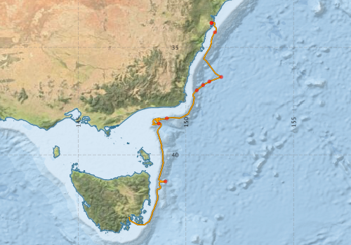
Voyage extents: 43° 15.5' S to 33° 49.7' S 147° 20.3' E to 151° 38.8' E Get voyage track shapefile Get CSV
Marlin Metadata:-
Participants - on ship:-
| Name | Role | Organisation |
|---|---|---|
| Amanda Roe | Student | University of Sydney |
| Amelia Shannon | Student (Swath) | University of Sydney |
| Ana Zivanovic | Ph.D. Student | University of Wollongong |
| Belinda Dechnik | Student | University of Sydney |
| Ben Harris | Ph.D. student (pelagic stations) | University of New South Wales - Centre for Marine Science |
| Bevan Yiu | Student | University of Sydney |
| Daniel Harrision | Student | University of the Sea |
| Hiski Kippo | MNF Computing Support | CSIRO Oceans & Atmosphere - Hobart |
| Jeff Cordell | MNF Voyage Manager/electronics support | CSIRO Oceans & Atmosphere - Hobart |
| Mark Lewis | Gear support | CSIRO Oceans & Atmosphere - Hobart |
| Matt Sherlock | Technician BOAGS | CSIRO Oceans & Atmosphere - Hobart |
| Natasha Henschke | 2nd watch leader | University of New South Wales - Centre for Marine Science |
| Ronald Thresher | Scientist (St Helens seamount) | CSIRO Oceans & Atmosphere - Hobart |
| Rudy Kloser | Scientist (BOAGS/swath) | CSIRO Oceans & Atmosphere - Hobart |
| Sebastian Holmes | Chief Scientist (1st watch leader) | University of Sydney |
This list includes those that may have only been on part of the voyage. See voyage reports on 'Reports and Maps' tab for details.
Marine National Facility Reports - plans, summaries and data processing
-
SS2010_T04 Voyage Plan
- includes objectives, investigator details, proposed data collection, voyage track and equipment to be used.
-
SS2010_T04 Underway Data Processing Report
- details of data processing steps, calibration information, instruments used and any issues with the data.
-
SS2010_T04 Scientific Highlight
- report of the key outputs
-
SS2010_T04 Voyage Summary
- includes preliminary results, voyage narrative, types of data collected with C77/ROSCOP codes.
-

Publications, reports and datasets from this voyage.
Dataset
- Smith, S. R.,Lopez, N.,Bourassa, M. A. (2016) SAMOS air‐sea fluxes: 2005–2014. Geoscience Data Journal 3 pp9-19. 10.1002/gdj3.34
Journal Article
- Partridge, J. C.,Douglas, R. H.,Marshall, N. J.,Chung, W.-S.,Jordan, T. M.,Wagner, H.-J. (2014) Reflecting optics in the diverticular eye of a deep-sea barreleye fish (Rhynchohyalus natalensis). Proceedings of the Royal Society B: Biological Sciences 281 pp20133223-. 10.1098/rspb.2013.3223
Search for publications, reports and datasets from this and other voyages
Data publishing
This is a list of online datasets hosted by CSIRO. Other processed datasets hosted by collaborating organisations may be found on the 'Metadata' or "Reports, Publications and Maps' tab.
Use the Get data link on the right to extract data using the NCMI Data Trawler.
| Data Stream | Data Summary | Get data | ||||||||||||||
|---|---|---|---|---|---|---|---|---|---|---|---|---|---|---|---|---|
| ADCP Data |
|
Get Data from Trawler Overview ADCP Dataset HTML Download NetCDF ss2010_t04_ADCP_nc.zip Download Processing Report ss2010_t04ADCP.pdf |
||||||||||||||
| CTD profile |
|
Get Data from Trawler Processing report: ss2010_t04ctd.pdf Download NetCDF data ss2010_t04_avg1db_CTDnc.zip Download Plots ss2010_t04_scanplots_CTDpng.zip |
||||||||||||||
| Multibeam echosounder |
|
Get Data from Trawler |
||||||||||||||
| Underway |
|
Get Data from Trawler Download 5 sec NetCDF dataset ss2010_t04UWYnc.zip |
||||||||||||||
| XBT Profile |
|
Get Data from Trawler Download xbt_ascii_ma_2007_2012.zip (MEDS ASCII format ) Download xbt_nc_ss2007_2012.zip (NetCDF format) |
Deployments by start time:- Click on column header to sort. Use link on 'Deployment' to see full details. Use the CSV button at the bottom to export data (tab delimited).
Search for deployments from this voyage and others
| Deployment | Operation | Station | Cast | Gear | Project | Start and end times | Start Location | End Location | Depth range | Max Depth | Description | |||
|---|---|---|---|---|---|---|---|---|---|---|---|---|---|---|
| Multibeam echosounder [details] | EM300 Multibeam Echosounder | 2010-10-31 23:37 | 2010-11-07 07:31 | -33.8629 | 151.1837 | -41.9726 | 148.6878 | 5908 | ||||||
| Underway System [details] | Air Temperature Sensor-HMT333,Barometer,Doppler speed log,Fluorometer WS3S-443P,Humidity Sensor-HMT333,IMOS Port Pyranometer-SN 35122F3,IMOS Port Radiometer-SN 35111F3,IMOS Stbd Pyranometer-SN 35123F3,IMOS Stbd Radiometer-SN 35093F3,IMOS rain gauge,IMOS rain gauge,IMOS wind monitor,IMOS wind monitor,Licor-UWQ 3708,RM Young 05106 wind monitor-75621,RM Young 05106 wind monitor-75621,RM Young 05106 wind monitor-75621,RM Young Rain Gauge,Remote Temperature (T)-SN 2621,Seapath 200,Seapath 200,Seapath 200,Simrad EK60 echosounder,ThermoSalinoGraph (TSG)-SS-SN 1777 | 2369 | 2010-11-02 19:00 | 2010-11-07 20:50 | -33.8629 | 151.1837 | -42.8863 | 147.3385 | ||||||
| ADCP Data [details] | RDI Ocean Surveyor Acoustic Doppler current profiler | 2369 | 2010-11-02 23:23 | 2010-11-07 02:02 | -34.2919 | 151.3471 | -41.2533 | 149.0276 | 653.5 | |||||
| CTD Cast [details] | 1 | Cast 1 | CTD 21,Conductivity CTD 21-SN 2312,Fluorometer-CTD 21 -Chelsea-06-5941-001,Licor - CTD 21 - SN 70111,Oxygen CTD 21-SBE 43-SN 1794,Pressure CTD 21,Temperature CTD 21 - SN 4718,Transmissometer - CTD 21 -CST-1016DR | 2369 | 2010-11-03 23:37 | 2010-11-03 23:51 | -36.3753 | 151.6400 | -36.3727 | 151.6422 | 402 | |||
| CTD Cast [details] | 2 | Cast 2 | CTD 21,Conductivity CTD 21-SN 2312,Fluorometer-CTD 21 -Chelsea-06-5941-001,Licor - CTD 21 - SN 70111,Oxygen CTD 21-SBE 43-SN 1794,Pressure CTD 21,Temperature CTD 21 - SN 4718,Transmissometer - CTD 21 -CST-1016DR | 2369 | 2010-11-04 04:06 | 2010-11-04 04:24 | -36.5855 | 151.0872 | -36.5921 | 151.0958 | 401 | |||
| CTD Cast [details] | 3 | Cast 3 | CTD 21,Conductivity CTD 21-SN 2312,Fluorometer-CTD 21 -Chelsea-06-5941-001,Licor - CTD 21 - SN 70111,Oxygen CTD 21-SBE 43-SN 1794,Pressure CTD 21,Temperature CTD 21 - SN 4718,Transmissometer - CTD 21 -CST-1016DR | 2369 | 2010-11-04 06:56 | 2010-11-04 07:12 | -36.7530 | 150.7934 | -36.7548 | 150.7958 | 401 | |||
| CTD Cast [details] | 4 | Cast 4 | CTD 21,Conductivity CTD 21-SN 2312,Fluorometer-CTD 21 -Chelsea-06-5941-001,Licor - CTD 21 - SN 70111,Oxygen CTD 21-SBE 43-SN 1794,Pressure CTD 21,Temperature CTD 21 - SN 4718,Transmissometer - CTD 21 -CST-1016DR | 2369 | 2010-11-04 10:21 | 2010-11-04 10:33 | -36.9970 | 150.5008 | -36.9948 | 150.5016 | 401 | |||
| XBT Cast [details] | Sippican Deep Blue | 2391 | 2010-11-05 01:16 | -38.3023 | 149.1103 | 1100.3 | ||||||||
| CTD Cast [details] | 5 | Cast 5 | CTD 21,Conductivity CTD 21-SN 2312,Fluorometer-CTD 21 -Chelsea-06-5941-001,Licor - CTD 21 - SN 70111,Oxygen CTD 21-SBE 43-SN 1794,Pressure CTD 21,Temperature CTD 21 - SN 4718,Transmissometer - CTD 21 -CST-1016DR | 2369 | 2010-11-05 09:08 | 2010-11-05 10:34 | -38.5494 | 148.7441 | -38.5412 | 148.7486 | 2399 | |||
| CTD Cast [details] | 6 | Cast 6 | CTD 21,Conductivity CTD 21-SN 2312,Fluorometer-CTD 21 -Chelsea-06-5941-001,Licor - CTD 21 - SN 70111,Oxygen CTD 21-SBE 43-SN 1794,Pressure CTD 21,Temperature CTD 21 - SN 4718,Transmissometer - CTD 21 -CST-1016DR | 2369 | 2010-11-07 00:09 | 2010-11-07 01:44 | -41.2399 | 149.0483 | -41.2457 | 149.0494 | 2500 | |||