Voyage details and related metadata, reports, events and data.
SS2010_T02
- is a Marine National Facility ![]() voyage
voyage
Period: 2010-08-10 09:00 to 2010-08-20 03:00 UTC
Duration: 9.75 days
From: Fremantle To: Hobart
Region: Benthic Protection Zone (BPZ) of the Great Australian Bight Marine Park (GABMP)
Ship: Southern Surveyor [details]
Description: Southern Surveyor Transit Voyage SS2010_T02, Fremantle to Hobart. Scientific Objectives The Benthic Protection Zone (BPZ) of the Great Australian Bight Marine Park (GABMP) was proclaimed in 1998, and consists of a 20 nautical-mile-wide strip of seafloor orientated north to south and extending from three nautical miles from the coast to the edge of Australia's Exclusive Economic Zone (EEZ), 200 nautical miles offshore (Figure 1). Within this zone, the benthic assemblages are protected from demersal trawling and other potentially destructive human activities. The BPZ is presently one of fourteen temperate Commonwealth Marine Protected Areas (MPAs) in Australia. These MPAs form part of an integrated strategy for marine conservation and management through the National Representative System of Marine Protected Areas (NRSMPA). At present, no data are available on the benthic biodiversity of the continental slope of the BPZ, or the environmental factors that affect their patterns of distribution and abundance. This research addresses this knowledge gap and aims to provide quantitative information on the regional significance and diversity of the deep-water faunal communities of the BPZ. Taken from ss2010_t02 Voyage Plan.
Leader: D Currie (SARDI Aquatic Sciences)
Project: National Facility External Users: D. Currie (SARDI) [details]
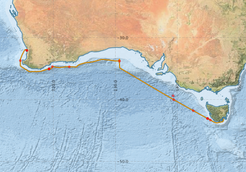
Voyage extents: 43° 47.6' S to 31° 57.2' S 114° 39.9' E to 147° 30.0' E Get voyage track shapefile Get CSV
Marlin Metadata:-
Metadata from OBIS Australia datasets:- biological data is published via the OBIS-AU IPT server and delivered to one or more of OBIS, ALA and GBIF
Download from OBIS Australia IPT View at - Ocean Biodiversity Information System (OBIS)
Download from OBIS Australia IPT View at - Ocean Biodiversity Information System (OBIS)
Download from OBIS Australia IPT View at - Ocean Biodiversity Information System (OBIS)
Download from OBIS Australia IPT View at - Ocean Biodiversity Information System (OBIS) Atlas of Living Australia (ALA) GBIF
Participants - on ship:-
| Name | Role | Organisation |
|---|---|---|
| Bernadette Heaney | MNF Swath Mapping Support | CSIRO Oceans & Atmosphere - Hobart |
| David Currie | Chief Investigator | South Australian Research and Development Institute |
| Karl Forcey | MNF Electronic Support | CSIRO Oceans & Atmosphere - Hobart |
| Laura Richardson | Oceanographer, PhD Student | Australian National University |
| Pamela Brodie | MNF Voyage Manager / Computing Support | CSIRO Oceans & Atmosphere - Hobart |
| Rod Simpson | Invertebrate Taxonomist | UNE |
| Saras Kumar | Invertebrate Taxonomist | DEH |
| Sue Reynolds | MNF Hydrochemistry | CSIRO Oceans & Atmosphere - Hobart |
This list includes those that may have only been on part of the voyage. See voyage reports on 'Reports and Maps' tab for details.
Marine National Facility Reports - plans, summaries and data processing
-
SS2010_T02 Voyage Plan
- includes objectives, investigator details, proposed data collection, voyage track and equipment to be used.
-
SS2010_T02 Underway Data Processing Report
- details of data processing steps, calibration information, instruments used and any issues with the data.
-
SS2010_T02 Scientific Highlight
- report of the key outputs
-
SS2010_T02 Voyage Summary
- includes preliminary results, voyage narrative, types of data collected with C77/ROSCOP codes.
-

Publications, reports and datasets from this voyage.
Dataset
- Bakker, Dorothee C E; Pfeil, Benjamin; Smith, Karl; Hankin, Steven; Olsen, Are; Alin, Simone R; Cosca, Catherine E; Harasawa, Sumiko; Kozyr, Alexander; Nojiri, Yukihiro; O'Brien, Kevin M; Schuster, Ute; Telszewski, Maciej; Tilbrook, Bronte; Wada, Chisato; Akl, John; Barbero, Leticia; Bates, Nicolas R; Boutin, Jacqueline; Bozec, Yann; Cai, Wei-Jun; Castle, Robert D; Chavez, Francisco P; Chen, Lei; Chierici, Melissa; Currie, Kim I; de Baar, Hein J W; Evans, Wiley; Feely, Richard A; Fransson, Agneta; Gao, Zhongyong; Hales, Burke; Hardman-Mountford, Nicolas J; Hoppema, Mario; Huang, Wei-Jen; Hunt, Christopher W; Huss, Betty; Ichikawa, Tadafumi; Johannessen, Truls; Jones, Elizabeth M; Jones, Steve D; Jutterstrøm, Sara; Kitidis, Vassilis; Körtzinger, Arne; Landschützer, Peter; Lauvset, Siv K; Lefèvre, Nathalie; Manke, Ansley; Mathis, Jeremy T; Merlivat, Liliane; Metzl, Nicolas; Murata, Akihiko; Newberger, Timothy; Omar, Abdirahman M; Ono, Tsuneo; Park, Geun-Ha; Paterson, Kristina; Pierrot, Denis; Ríos, Aida F; Sabine, Christopher L; Saito, Shu; Salisbury, Joe; Sarma, Vedula V S S; Schlitzer, Reiner; Sieger, Rainer; Skjelvan, Ingunn; Steinhoff, Tobias; Sullivan, Kevin; Sun, Heng; Sutton, Adrienne; Suzuki, Toru; Sweeney, Colm; Takahashi, Taro; Tjiputra, Jerry; Tsurushima, Nobuo; van Heuven, Steven; Vandemark, Doug; Vlahos, Penny; Wallace, Douglas WR; Wanninkhof, Rik; Watson, Andrew J (2014): Surface Ocean CO2 Atlas (SOCAT) V2. PANGAEA, 10.1594/PANGAEA.811776
- Smith, S. R.,Lopez, N.,Bourassa, M. A. (2016) SAMOS air‐sea fluxes: 2005–2014. Geoscience Data Journal 3 pp9-19. 10.1002/gdj3.34
IPT Resource
- The Cymonomid Crabs of of Australia (Crustacea: Brachyura: Cyclodorripoida) (Darwin Core Archive) External link to reference
- Collection data of Tethya irisae sp. nov. and comparative material, Great Australian Bight, Australia (Darwin Core Archive) External link to reference
- Global benthic biogeographical regions and macroecological drivers for ophiuroids [Data set] (Darwin Core Archive) External link to reference
- Trawl and Grab infaunal samples from the Great Australian Bight - Southern Surveyor voyage SS2010_T02 (2010) (Darwin Core Archive) External link to reference
Journal Article
- Power, H. E.,Clarke, S. L. (2019) 3D seismic-derived bathymetry: a quantitative comparison with multibeam data. Geo-Marine Letters 39 pp447-467. 10.1007/s00367-019-00596-w
- Richardson, L.E.,Middleton, J.F.,Kyser, T.K.,James, N.P.,Opdyke, B.N. (2019) Shallow water masses and their connectivity along the southern Australian continental margin. Deep Sea Research Part I: Oceanographic Research Papers 152 pp103083-. 10.1016/j.dsr.2019.103083
- Sorokin, S J., Ekins, M G., Yang, Q., Cárdenas, P. (2019) A new deep-water Tethya (Porifera, Tethyida, Tethyidae) from the Great Australian Bight and an updated Tethyida phylogeny. European Journal of Taxonomy n. 529, June 2019. 10.5852/ejt.2019.529
Report
- Currie, D; Sorokin, Shirley J (2011): A preliminary assessment of the deepwater benthic communities of the Great Australian Bight Marine Park. Report to the South Australian Department of Environment and Natural Resources and the Commonwealth Department of Sustainability, Environment, Water, Populations and Communities, SARDI Aquatic Sciences Publication, Adelaide, F2011/000526-1 External link to reference
Search for publications, reports and datasets from this and other voyages
Data publishing
This is a list of online datasets hosted by CSIRO. Other processed datasets hosted by collaborating organisations may be found on the 'Metadata' or "Reports, Publications and Maps' tab.
Use the Get data link on the right to extract data using the NCMI Data Trawler.
| Data Stream | Data Summary | Get data | ||||||||||||||
|---|---|---|---|---|---|---|---|---|---|---|---|---|---|---|---|---|
| ADCP Data |
|
Get Data from Trawler Download netCDF dataset ss2010_t02_adcp.zip (authorisation required) ss2010_t02_ADCP processing report .pdf (authorisation required) |
||||||||||||||
| Marine biodiversity observations and/or samples |
|
Get Data from Trawler |
||||||||||||||
| CTD profile |
|
Get Data from Trawler Download NetCDF data ss2010_t02_CTDnc.zip (Authorisation Required) Processing report: ss2010_t02ctd.doc |
||||||||||||||
| Hydrology |
|
Get Data from Trawler |
||||||||||||||
| Multibeam echosounder |
|
Get Data from Trawler |
||||||||||||||
| pCO2 |
|
External link - download datafile at IMOS |
||||||||||||||
| Underway |
|
Get Data from Trawler Download 5 sec NetCDF dataset ss2010_t02UWYnc.zip |
||||||||||||||
| XBT Profile |
|
Get Data from Trawler Download xbt_ascii_ma_2007_2012.zip (MEDS ASCII format ) Download xbt_nc_ss2007_2012.zip (NetCDF format) |
| ID | When (UTC) | Lat | Long | Instrument | Identifier | Action | Log | Subject / Comment |
|---|
Deployments by start time:- Click on column header to sort. Use link on 'Deployment' to see full details. Use the CSV button at the bottom to export data (tab delimited).
Search for deployments from this voyage and others
| Deployment | Operation | Station | Cast | Gear | Project | Start and end times | Start Location | End Location | Depth range | Max Depth | Description | |||
|---|---|---|---|---|---|---|---|---|---|---|---|---|---|---|
| Underway System [details] | Air Temperature Sensor-HMT333,Barometer,Doppler speed log,Fluorometer WS3S-443P,Humidity Sensor-HMT333,IMOS Port Pyranometer-SN 35122F3,IMOS Port Radiometer-SN 35111F3,IMOS Stbd Pyranometer-SN 35123F3,IMOS Stbd Radiometer-SN 35093F3,IMOS rain gauge,IMOS rain gauge,IMOS wind monitor,IMOS wind monitor,Licor-UWQ 3708,RM Young 05106 wind monitor-75621,RM Young 05106 wind monitor-75621,RM Young 05106 wind monitor-75621,RM Young Rain Gauge,Remote Temperature (T)-SN 2621,Seapath 200,Seapath 200,Seapath 200,Simrad EK60 echosounder,ThermoSalinoGraph (TSG)-SS-SN 1777 | 2246 | 2010-08-10 09:15 | 2010-08-19 22:00 | -32.0544 | 115.7342 | -43.1303 | 147.4304 | ||||||
| Multibeam echosounder [details] | EM300 Multibeam Echosounder | 2010-08-10 09:21 | 2010-08-19 23:01 | -32.0568 | 115.7164 | -43.0700 | 147.3956 | 5962.1 | ||||||
| ADCP Data [details] | RDI Ocean Surveyor Acoustic Doppler current profiler | 2246 | 2010-08-10 21:26 | 2010-08-19 12:14 | -33.7078 | 114.6664 | -43.7181 | 146.1353 | 798 | |||||
| XBT Cast [details] | Sippican Deep Blue | 2391 | 2010-08-12 01:13 | -35.0574 | 119.2933 | 1100.3 | ||||||||
| XBT Cast [details] | Sippican Deep Blue | 2391 | 2010-08-12 01:35 | -35.0549 | 119.3123 | 1100.3 | ||||||||
| CTD Cast / Hydrology [details] | 1 | Cast 1 | Altitude CTD 21-41023,CTD 21,Conductivity CTD 21-SN 2312,Fluorometer-CTD 21 -Chelsea-06-5941-001,Licor - CTD 21 - SN 70111,Oxygen CTD 21-SBE 43-SN 1794,Pressure CTD 21,Temperature CTD 21 - SN 4718,Transmissometer - CTD 21 -CST-1016DR | 2246 | 2010-08-12 05:49 | 2010-08-12 06:31 | -34.6858 | 119.8407 | -34.6855 | 119.8419 | 1002 | |||
| CTD Cast / Hydrology [details] | 1 | Cast 2 | Altitude CTD 21-41023,CTD 21,Conductivity CTD 21-SN 2312,Fluorometer-CTD 21 -Chelsea-06-5941-001,Licor - CTD 21 - SN 70111,Oxygen CTD 21-SBE 43-SN 1794,Pressure CTD 21,Temperature CTD 21 - SN 4718,Transmissometer - CTD 21 -CST-1016DR | 2246 | 2010-08-12 20:23 | 2010-08-12 21:03 | -34.7105 | 122.5696 | -34.7102 | 122.5700 | 950 | |||
| CTD Cast / Hydrology [details] | 1 | Cast 3 | Altitude CTD 21-41023,CTD 21,Conductivity CTD 21-SN 2312,Fluorometer-CTD 21 -Chelsea-06-5941-001,Licor - CTD 21 - SN 70111,Oxygen CTD 21-SBE 43-SN 1794,Pressure CTD 21,Temperature CTD 21 - SN 4718,Transmissometer - CTD 21 -CST-1016DR | 2246 | 2010-08-15 03:47 | 2010-08-15 04:31 | -33.7861 | 130.6887 | -33.7939 | 130.6975 | 982 | |||
| ARGO float [details] | 6988 | 2394 | 2010-08-17 16:43 | -39.3900 | 139.3300 | Owner: BOM 09/10 CTD Type: SBE 41 CP 2.0 Serial number: 3168 | ||||||||
| ARGO float [details] | 6989 | 2394 | 2010-08-17 22:46 | -40.0200 | 139.4400 | Owner: BOM 09/10 CTD Type: SBE 41 CP 2.0 Serial number: 3169 | ||||||||
| ARGO float [details] | 6990 | 2394 | 2010-08-18 23:51 | -41.8000 | 142.5900 | Owner: BOM 09/10 CTD Type: SBE 41 CP 2.0 Serial number: 3170 | ||||||||
| ARGO float [details] | 6991 | 2394 | 2010-08-19 03:34 | -43.0700 | 144.9000 | Owner: BOM 09/10 CTD Type: SBE 41 CP 2.0 Serial number: 3174 | ||||||||
| CTD Cast / Hydrology [details] | 1 | Cast 4 | Altitude CTD 21-41023,CTD 21,Conductivity CTD 21-SN 2312,Fluorometer-CTD 21 -Chelsea-06-5941-001,Licor - CTD 21 - SN 70111,Oxygen CTD 21-SBE 43-SN 1794,Pressure CTD 21,Temperature CTD 21 - SN 4718,Transmissometer - CTD 21 -CST-1016DR | 2246 | 2010-08-19 04:07 | 2010-08-19 04:52 | -43.0818 | 144.9049 | -43.0914 | 144.9031 | 1002 | |||
| CTD Cast / Hydrology [details] | 1 | Cast 5 | Altitude CTD 21-41023,CTD 21,Conductivity CTD 21-SN 2312,Fluorometer-CTD 21 -Chelsea-06-5941-001,Licor - CTD 21 - SN 70111,Oxygen CTD 21-SBE 43-SN 1794,Pressure CTD 21,Temperature CTD 21 - SN 4718,Transmissometer - CTD 21 -CST-1016DR | 2246 | 2010-08-19 07:45 | 2010-08-19 08:23 | -43.3109 | 145.3505 | -43.3115 | 145.3541 | 998 | |||