Voyage details and related metadata, reports, events and data.
SS 06/2008
(alternative identifier: SS200806)
- is a Marine National Facility ![]() voyage
voyage
Period: 2008-04-16 00:00 to 2008-04-29 00:00 UTC
Duration: 13.00 days
From: Sydney To: Noumea
Region: Lord Howe Island
Ship: Southern Surveyor [details]
Description:
Voyage Title: Morphology and Chronostratigraphy of fossil reefs around Lord Howe Island.
Voyage Objectives: This research aims to extend our understanding of seamount habitats in the Tasman Sea, specifically mapping the bathymetry and substrate of environments around Lord Howe Island and Balls Pyramid.
Leader: Professor Colin D. Woodroffe (Wollongong University); Dr Brendan Brooke (GA)
Project: National Facility External Users: C. Woodroffe (University of Wollongong) [details]
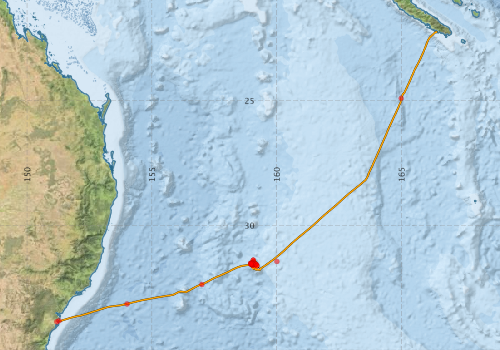
Voyage extents: 33° 50.2' S to 22° 14.6' S 151° 16.7' E to 166° 25.9' E Get voyage track shapefile Get CSV
Marlin Metadata:-
Metadata from OBIS Australia datasets:- biological data is published via the OBIS-AU IPT server and delivered to one or more of OBIS, ALA and GBIF
Download from OBIS Australia IPT View at - Ocean Biodiversity Information System (OBIS) Atlas of Living Australia (ALA) GBIF
Participants - on ship:-
| Name | Role | Organisation |
|---|---|---|
| Andrew Hislop | Mechanical Technician | Geoscience Australia |
| Brendan Brooke | Deputy Chief Scientist | Geoscience Australia |
| Brian Jones | Senior Scientist | SEES, UOW |
| Cameron Buchanan | Swath Technician | Geoscience Australia |
| Colin Woodroffe | Chief Investigator | SEES, UOW |
| David Kennedy | Geologist | VU, Wellington, NZ |
| Franz Villagran | Electronics Technician | Geoscience Australia |
| Gareth Crooke | Mechanical Technician | Geoscience Australia |
| Jack Pittar | Electronics Technician | Geoscience Australia |
| Javier Leon | PhD student, geospatial | Geoscience Australia |
| John Jaycock | Science Technician | Geoscience Australia |
| Lindsay MacDonald | Electronics Support | CSIRO Oceans & Atmosphere - Hobart |
| Lindsay Pender | Computing Support | CSIRO Oceans & Atmosphere - Hobart |
| Matt McArthur | Benthic Ecologist | Geoscience Australia |
| Ron Plaschke | Voyage Manager and Ops. Supp | CSIRO Oceans & Atmosphere - Hobart |
This list includes those that may have only been on part of the voyage. See voyage reports on 'Reports and Maps' tab for details.
Marine National Facility Reports - plans, summaries and data processing
-
SS200806 Voyage Plan
- includes objectives, investigator details, proposed data collection, voyage track and equipment to be used.
-
SS200806 Voyage Summary
- includes preliminary results, voyage narrative, types of data collected with C77/ROSCOP codes.
-
SS200806 Scientific Highlight
- report of the key outputs
-

Publications, reports and datasets from this voyage.
Dataset
- Bakker, Dorothee C E; Pfeil, Benjamin; Smith, Karl; Hankin, Steven; Olsen, Are; Alin, Simone R; Cosca, Catherine E; Harasawa, Sumiko; Kozyr, Alexander; Nojiri, Yukihiro; O'Brien, Kevin M; Schuster, Ute; Telszewski, Maciej; Tilbrook, Bronte; Wada, Chisato; Akl, John; Barbero, Leticia; Bates, Nicolas R; Boutin, Jacqueline; Bozec, Yann; Cai, Wei-Jun; Castle, Robert D; Chavez, Francisco P; Chen, Lei; Chierici, Melissa; Currie, Kim I; de Baar, Hein J W; Evans, Wiley; Feely, Richard A; Fransson, Agneta; Gao, Zhongyong; Hales, Burke; Hardman-Mountford, Nicolas J; Hoppema, Mario; Huang, Wei-Jen; Hunt, Christopher W; Huss, Betty; Ichikawa, Tadafumi; Johannessen, Truls; Jones, Elizabeth M; Jones, Steve D; Jutterstrøm, Sara; Kitidis, Vassilis; Körtzinger, Arne; Landschützer, Peter; Lauvset, Siv K; Lefèvre, Nathalie; Manke, Ansley; Mathis, Jeremy T; Merlivat, Liliane; Metzl, Nicolas; Murata, Akihiko; Newberger, Timothy; Omar, Abdirahman M; Ono, Tsuneo; Park, Geun-Ha; Paterson, Kristina; Pierrot, Denis; Ríos, Aida F; Sabine, Christopher L; Saito, Shu; Salisbury, Joe; Sarma, Vedula V S S; Schlitzer, Reiner; Sieger, Rainer; Skjelvan, Ingunn; Steinhoff, Tobias; Sullivan, Kevin; Sun, Heng; Sutton, Adrienne; Suzuki, Toru; Sweeney, Colm; Takahashi, Taro; Tjiputra, Jerry; Tsurushima, Nobuo; van Heuven, Steven; Vandemark, Doug; Vlahos, Penny; Wallace, Douglas WR; Wanninkhof, Rik; Watson, Andrew J (2014): Surface Ocean CO2 Atlas (SOCAT) V2. PANGAEA, 10.1594/PANGAEA.811776
- Linklater, Michelle (2020), Bathymetry grid (5 m cell size) for Lord Howe Island and Balls Pyramid shelves, southwest Pacific Ocean, Mendeley Data, V2 10.17632/dghd5gr8gz
- McArthur, M. (2011) Lord Howe Island Infaunal data. Geoscience Australia, Canberra. External link to reference
- Smith, S. R.,Lopez, N.,Bourassa, M. A. (2016) SAMOS air‐sea fluxes: 2005–2014. Geoscience Data Journal 3 pp9-19. 10.1002/gdj3.34
- Spinoccia, M. (2011) Bathymetry grid of Lord Howe Island. Geoscience Australia, Canberra. 10.4225/25/53D9AF086640B
IPT Resource
- Lord Howe Island Infaunal data, Australia (2008) (Darwin Core Archive) External link to reference
Journal Article
- Anderson, T.J.,McArthur, M.A.,Syms, C.,Nichol, S.,Brooke, B. (2013) Infaunal biodiversity and ecological function on a remote oceanic island: The role of biogeography and bio-physical surrogates. Estuarine, Coastal and Shelf Science 117 pp227-237. 10.1016/j.ecss.2012.11.013
- Brendan P. Brooke, Matthew A. McArthur, Colin D. Woodroffe, Michelle Linklater, Scott L.Nichol, Tara J.Anderson, Richard Mleczko , Stephen Sagar (2012) Geomorphic features and infauna diversity of a subtropical mid-ocean carbonate shelf: Lord Howe Island, Southwest Pacific Ocean. In: Harris, P.T and Baker, E. (Eds), Atlas of Seafloor Geomorphology as Habitat, Elsevier Insights. Pp. 367-378. 10.1016/B978-0-12-385140-6.00025-6
- Kennedy, D.M.,Brooke, B.P.,Woodroffe, C.D.,Jones, B.G.,Waikari, C.,Nichol, S. (2011) The geomorphology of the flanks of the Lord Howe Island volcano, Tasman Sea, Australia. Deep Sea Research Part II: Topical Studies in Oceanography 58 pp899-908. 10.1016/j.dsr2.2010.10.046
- Linklater, M., Hamylton, S. M., Brooke, B. P., Nichol, S. L., Jordan, A. R. & Woodroffe, C. D. (2018). Development of a seamless, high-resolution bathymetric model to compare reef morphology around the subtropical island shelves of Lord Howe Island and Balls Pyramid, southwest Pacific Ocean. Geosciences, 8 (1), 11-1-11-25. 10.3390/geosciences8010011
- Lucieer, Vanessa,Flukes, Emma,Monk, Jacquomo,Walsh, Peter (2024) Geomorphometric maps of Australia’s Marine Park estate and their role in improving the integrated monitoring and management of marine ecosystems. Frontiers in Marine Science 10 pp-. 10.3389/fmars.2023.1302108
- McArthur, M.A.,Brooke, B.P.,Przeslawski, R.,Ryan, D.A.,Lucieer, V.L.,Nichol, S.,McCallum, A.W.,Mellin, C.,Cresswell, I.D.,Radke, L.C. (2010) On the use of abiotic surrogates to describe marine benthic biodiversity. Estuarine, Coastal and Shelf Science 88 pp21-32. 10.1016/j.ecss.2010.03.003
- McCarthy, A.,Falloon, T.J.,Danyushevsky, L.V.,Sauermilch, I.,Patriat, M.,Jean, M.M.,Maas, R.,Woodhead, J.D.,Yogodzinski, G.M. (2022) Implications of high-Mg# adakitic magmatism at Hunter Ridge for arc magmatism of the Fiji - Vanuatu region. Earth and Planetary Science Letters 590 pp117592-. 10.1016/j.epsl.2022.117592
- Woodroffe, Colin D.,Brooke, Brendan P.,Linklater, Michelle,Kennedy, David M.,Jones, Brian G. (2010) Response of coral reefs to climate change: Expansion and demise of the southernmost Pacific coral reef. Geophysical Research Letters 37 ppn/a-n/a. 10.1029/2010GL044067
Report
- Brooke, B.P., Woodroffe, C.D., Linklater, M., McArthur, M.A., Nichol, S.L., Jones, B.G., Kennedy, D.M., Buchanan, C., Spinoccia, M., Mleczko, R., Cortese, A., Atkinson, I. and Sexton, M. (2010), Geomorphology of the Lord Howe Island shelf and submarine volcano. SS06-2008 Post-Survey Report. Geoscience Australia Record 2010/26. Geoscience Australia, Canberra. 125. External link to reference
- McArthur, M. (2011) Lord Howe Island Infauna Images. Geoscience Australia, Canberra. External link to reference
Search for publications, reports and datasets from this and other voyages
Data publishing
This is a list of online datasets hosted by CSIRO. Other processed datasets hosted by collaborating organisations may be found on the 'Metadata' or "Reports, Publications and Maps' tab.
Use the Get data link on the right to extract data using the NCMI Data Trawler.
| Data Stream | Data Summary | Get data | ||||||||||||
|---|---|---|---|---|---|---|---|---|---|---|---|---|---|---|
| ADCP Data |
|
Get Data from Trawler Download netCDF dataset ss200806adcp.zip SS200806_UWY_ADCP_Report.pdf |
||||||||||||
| Marine biodiversity observations and/or samples |
|
Get Data from Trawler |
||||||||||||
| Multibeam echosounder |
|
Get Data from Trawler |
||||||||||||
| pCO2 |
|
External link - download datafile at IMOS |
||||||||||||
| Underway |
|
Get Data from Trawler |
| ID | When (UTC) | Lat | Long | Instrument | Identifier | Action | Log | Subject / Comment |
|---|
Deployments by start time:- Click on column header to sort. Use link on 'Deployment' to see full details. Use the CSV button at the bottom to export data (tab delimited).
Search for deployments from this voyage and others
| Deployment | Operation | Station | Cast | Gear | Project | Start and end times | Start Location | End Location | Depth range | Max Depth | Description | |||
|---|---|---|---|---|---|---|---|---|---|---|---|---|---|---|
| Multibeam echosounder [details] | EM300 Multibeam Echosounder | 2008-04-16 00:08 | 2008-04-28 19:57 | -33.8630 | 151.1842 | -22.2446 | 166.3973 | 5172.2 | ||||||
| Underway System [details] | Air Temperature Sensor-HMP233,Barometer,Fluorometer WS3S-443P,Gyro-Generic SS-NF,Humidity Sensor-HMP233,Licor - CTD 21 - SN 70111,Licor-UWQ 3708,RM Young 05106 wind monitor-75621,RM Young 05106 wind monitor-75621,RM Young 05106 wind monitor-75621,RM Young Rain Gauge,Seapath 200,Seapath 200,Simrad EA500 Echosounder,ThermoSalinoGraph (TSG)-SN 2753 | 109 | 2008-04-16 00:59 | 2008-04-28 20:26 | -33.8262 | 151.2776 | -22.2625 | 166.4324 | ||||||
| ARGO float [details] | 33374 | 2394 | 2008-04-16 14:52 | -33.1500 | 154.0000 | Owner: RAN CTD Type: SBE-41 Serial number: 3741 | ||||||||
| ARGO float [details] | 33375 | 2394 | 2008-04-17 06:31 | -32.3700 | 157.0000 | Owner: RAN CTD Type: SBE-41 Serial number: 3742 | ||||||||
| ADCP Data [details] | RDI Ocean Surveyor Acoustic Doppler current profiler | 109 | 2008-04-25 10:29 | 2008-04-25 13:44 | -31.5514 | 158.9654 | -22.3740 | 166.2382 | 799 | |||||
| ADCP Data [details] | 109 | 2008-04-25 14:14 | 2008-04-28 18:51 | -31.6175 | 159.2131 | -22.3740 | 166.2382 | 799 | ||||||
| ARGO float [details] | 33371 | 2394 | 2008-04-27 21:29 | -24.9100 | 164.9900 | Owner: IMOS CTD Type: SBE-41 Serial number: 3717 | ||||||||
| Sediment Sampling [details] | SS062008/03GRSM04a | 109 | -31.5908 | 159.0440 | ||||||||||
| Sediment Sampling [details] | SS062008/04GRSM01a | 109 | -31.5862 | 159.0353 | ||||||||||
| Sediment Sampling [details] | SS062008/04GRSM02a | 109 | -31.5548 | 159.1650 | ||||||||||
| Sediment Sampling [details] | SS062008/20GRSM03a | 109 | -31.6180 | 159.1200 | ||||||||||
| Sediment Sampling [details] | SS062008/05GRSM01a | 109 | -31.5163 | 158.9918 | ||||||||||
| Sediment Sampling [details] | SS062008/06GRSM01a | 109 | ||||||||||||
| Sediment Sampling [details] | SS062008/06GRSM02a | 109 | -31.5648 | 159.0373 | ||||||||||
| Sediment Sampling [details] | SS062008/06GRSM03a | 109 | -31.5648 | 159.0365 | ||||||||||
| Sediment Sampling [details] | SS062008/07GRSM01a | 109 | -31.5643 | 159.0363 | ||||||||||
| Sediment Sampling [details] | SS062008/10GRSM01a | 109 | -31.5167 | 158.9563 | ||||||||||
| Sediment Sampling [details] | SS062008/10GRSM02a | 109 | -31.5332 | 158.9560 | ||||||||||
| Sediment Sampling [details] | SS062008/10GRSM03a | 109 | -31.5050 | 159.0462 | ||||||||||
| Sediment Sampling [details] | SS062008/11GRSM01a | 109 | -31.5050 | 159.0468 | ||||||||||
| Sediment Sampling [details] | SS062008/12GRSM01a | 109 | -31.5043 | 159.0458 | ||||||||||
| Sediment Sampling [details] | SS062008/12GRSM02a | 109 | -31.4768 | 159.0580 | ||||||||||
| Sediment Sampling [details] | SS062008/12GRSM03a | 109 | -31.4925 | 159.0470 | ||||||||||
| Sediment Sampling [details] | SS062008/16GRSM01a | 109 | -31.5770 | 159.0037 | ||||||||||
| Sediment Sampling [details] | SS062008/18SM01a | 109 | -31.5767 | 159.0033 | ||||||||||
| Sediment Sampling [details] | SS062008/19GRSM01a | 109 | -31.4467 | 160.0067 | ||||||||||
| Sediment Sampling [details] | SS062008/19GRSM02a` | 109 | -31.3980 | 159.0593 | ||||||||||
| Sediment Sampling [details] | SS062008/19GRSM03a | 109 | -31.3980 | 159.0595 | ||||||||||
| Sediment Sampling [details] | SS062008/03GRSM02a | 109 | -31.5545 | 159.0352 | ||||||||||
| Sediment Sampling [details] | SS062008/03GRSM01a | 109 | -31.5447 | 159.0235 | ||||||||||
| Sediment Sampling [details] | SS062008/02GRSM03a | 109 | -31.5310 | 159.0132 | ||||||||||
| Sediment Sampling [details] | SS062008/02GRSM02a | 109 | -31.5166 | 158.9910 | ||||||||||
| Sediment Sampling [details] | SS062008/02GRSM01a | 109 | -31.5667 | 159.1603 | ||||||||||
| Sediment Sampling [details] | SS062008/01GRSM04a | 109 | -31.5683 | 159.1695 | ||||||||||
| Sediment Sampling [details] | SS062008/01GRSM03a | 109 | -31.5558 | 159.0172 | ||||||||||
| Sediment Sampling [details] | SS062008/04GRSM03a | 109 | -31.5164 | 158.9910 | ||||||||||