Voyage details and related metadata, reports, events and data.
SS 06/2007
(alternative identifier: SS200706)
- is a Marine National Facility ![]() voyage
voyage
Period: 2007-07-25 00:00 to 2007-08-13 05:30 UTC
Duration: 19.23 days
From: Madang To: Madang
Region: Bismark Sea, Papua New Guinea
Ship: Southern Surveyor [details]
Description:
Volcanism and tectonism of the South Bismarck Microplate,Papua New Guinea.
Voyage Objectives
To study the space - time distribution of the volcanic activity in order to investigate its relationships to the tectonic development fo the South Bismark Microplate, with the aim of understanding deviations from the normal patterns of volcanic activity associated with subduction and termination of subduction.
Scientific Objectives
- To build on background reconnaissance carried out by previous expeditions (FR 02/2002 and RV Kilo Moana 0419) in the submerged protions of the Bismark Arc in order to characterise the petrogenesis and tectonic setting of the previously unknown volcanic centres. Dredging and sticky wax coring will recover fresh glassy volcanic rock samples. Glasses and bulk rock samples will be analysed for major, trace and volitile elements together with isotopic abundances to determine the volatile contents and melting processes, identify mantle sources including "Indian"-type and possible Manus plume components, and hence obtain insights into upper mantle flows associated with arc-continent collisopn on the northern margin of the Australian Plate.
- To test young volcanic features for evidence of associated hydrothermal activity. This will be done using a similar plume-location and characterisation approach used on previous voyages by the Chief Scientist and his collaborators.
Leader: R. Arculus (ANU)
Project: National Facility External Users: R. J. Arculus (ANU) [details]
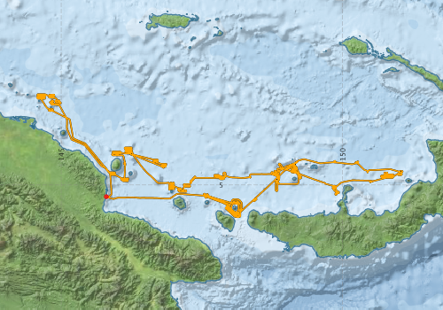
Voyage extents: 5° 34.2' S to 3° 23.3' S 144° 33.6' E to 151° 04.1' E Get voyage track shapefile Get CSV
Marlin Metadata:-
Participants - on ship:-
| Name | Role | Organisation |
|---|---|---|
| Bob Beattie | Voyage Manager/Computing | CSIRO Oceans & Atmosphere - Hobart |
| Camilla Stark | Water Column Sampling | CSIRO Exploration and Mining |
| Chris Yeats | Ore Deposit Geology | CSIRO Exploration and Mining |
| David Fuentes | Water Column Sampling | CSIRO Petroleum |
| Drew Mills | Electronics Support | CSIRO Oceans & Atmosphere - Hobart |
| Heather Cunningham | Geochemistry | Macquarie University |
| Richard Arculus | Petrology/Tectonics/Chief Scientist | Australian National University |
| Sarah O'Callaghan | Petrology/Tectonics | Australian National University |
| Shannon Johns | Ore Deposit Geology | CSIRO Exploration and Mining |
| Simon Day | Tectonics | University of California |
| Tarum Whan | Student | Australian National University |
This list includes those that may have only been on part of the voyage. See voyage reports on 'Reports and Maps' tab for details.
Marine National Facility Reports - plans, summaries and data processing
-
SS200706 Voyage Plan
- includes objectives, investigator details, proposed data collection, voyage track and equipment to be used.
-
SS200706 Underway Data Processing Report
- details of data processing steps, calibration information, instruments used and any issues with the data.
-
SS200706 Scientific Highlight
- report of the key outputs
-
SS200706 Voyage Summary
- includes preliminary results, voyage narrative, types of data collected with C77/ROSCOP codes.
-

Publications, reports and datasets from this voyage.
Journal Article
- Bénard, A.,Arculus, R.J.,Nebel, O.,Ionov, D.A.,McAlpine, S.R.B. (2017) Silica-enriched mantle sources of subalkaline picrite-boninite-andesite island arc magmas. Geochimica et Cosmochimica Acta 199 pp287-303. 10.1016/j.gca.2016.09.030
- Tollan, P M E,Dale, C W,Hermann, J,Davidson, J P,Arculus, R J (2017) Generation and Modification of the Mantle Wedge and Lithosphere beneath the West Bismarck Island Arc: Melting, Metasomatism and Thermal History of Peridotite Xenoliths from Ritter Island. Journal of Petrology 58 pp1475-1510. 10.1093/petrology/egx062
Search for publications, reports and datasets from this and other voyages
Data publishing
This is a list of online datasets hosted by CSIRO. Other processed datasets hosted by collaborating organisations may be found on the 'Metadata' or "Reports, Publications and Maps' tab.
Use the Get data link on the right to extract data using the NCMI Data Trawler.
| Data Stream | Data Summary | Get data | ||||||||||||
|---|---|---|---|---|---|---|---|---|---|---|---|---|---|---|
| Multibeam echosounder |
|
Get Data from Trawler |
||||||||||||
| Underway |
|
Get Data from Trawler |
Deployments by start time:- Click on column header to sort. Use link on 'Deployment' to see full details. Use the CSV button at the bottom to export data (tab delimited).
Search for deployments from this voyage and others
| Deployment | Operation | Station | Cast | Gear | Project | Start and end times | Start Location | End Location | Depth range | Max Depth | Description | |||
|---|---|---|---|---|---|---|---|---|---|---|---|---|---|---|
| Underway System [details] | Air Temperature Sensor-HMP233,Barometer,Fluorometer WS3S-443P,Gyro-Generic SS-NF,Humidity Sensor-HMP233,Licor-UWQ 3708,RM Young 05106 wind monitor-75621,RM Young 05106 wind monitor-75621,RM Young 05106 wind monitor-75621,RM Young Rain Gauge,Seapath 200,Seapath 200,Simrad EA500 Echosounder,ThermoSalinoGraph (TSG)-SS-SN 1777,ThermoSalinoGraph (TSG)-SS-SN 1777 | 1707 | 2007-07-25 08:02 | 2007-08-13 06:42 | -5.2097 | 145.8005 | -5.2082 | 145.8004 | ||||||
| Multibeam echosounder [details] | EM300 Multibeam Echosounder | 2007-07-25 08:30 | 2007-08-12 23:20 | -5.2094 | 145.7988 | -5.2328 | 146.6241 | 2276.9 | ||||||