Voyage details and related metadata, reports, events and data.
SS 03/2007
(alternative identifier: SS200703)
- is a Marine National Facility ![]() voyage
voyage
Period: 2007-04-12 09:30 to 2007-04-18 23:00 UTC
Duration: 6.56 days
From: Hobart To: Hobart
Region: Tasman Sea
Ship: Southern Surveyor [details]
Description:
Deep Ocean Tsunami Detection Buoy (DART) deployment for the Australian Tsunami Warning System (ATWS).
Scientific Objectives
The Australian Tsunami Warning System (ATWS) is a national effort between the Australian Bureau of Meteorology, Geoscience Australia and Emergency Management Australia to provide a comprehensive tsumani warning system capable of delivering timely and effective tsunami warnings to the Australian population by 2009, whilst supporting international efforts to establish an Indian Ocean tsunami warning system, and contributing to the faciliation of tsunami warnings for the South West Pacific.
Voyage Objectives
To deploy the first DART buoy in the South East Tasman Sea (160.467E 46.933S), some 1200 km from Tasmania. A second DART buoy will be deployed in the same envelope of potential siting late 2007/early 2008 (taken from SS03/2007 voyage plan).
Leader: R. Bailey (BoM)
Project: National Facility External Users: R. Bailey (Bureau of Meteorology) [details]
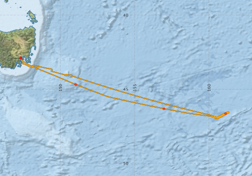
Voyage extents: 46° 59.5' S to 42° 53.2' S 147° 20.3' E to 161° 21.3' E Get voyage track shapefile Get CSV
Marlin Metadata:-
Participants - on ship:-
| Name | Role | Organisation |
|---|---|---|
| Cameron Buchanan | Swath mapping | Geoscience Australia |
| Diana Reale | Observer | CSIRO Oceans & Atmosphere - Hobart |
| Lee Tretbar | Senior Mechanical Technician | SAIC/NOAA |
| Lindsay MacDonald | Voyage Manager/ Electronics Support | CSIRO Oceans & Atmosphere - Hobart |
| Lindsay Pender | Computing Support | CSIRO Oceans & Atmosphere - Hobart |
| Rick Bailey | Chief Investigator | Bureau of Meteorology |
| Ross Hibbins | Deployment Observer | Bureau of Meteorology |
| TBC | Camera person | TBC |
| TBC | Deployment Observer | Bureau of Meteorology |
| William M Brewer | Senior Electronics Technician | National Oceanic and Atmospheric Administration |
This list includes those that may have only been on part of the voyage. See voyage reports on 'Reports and Maps' tab for details.
Marine National Facility Reports - plans, summaries and data processing
-
SS200703 Voyage Plan
- includes objectives, investigator details, proposed data collection, voyage track and equipment to be used.
-
SS200703 Underway Data Processing Report
- details of data processing steps, calibration information, instruments used and any issues with the data.
-
SS200703 Scientific Highlight
- report of the key outputs
-

Search for publications, reports and datasets from this and other voyages
Data publishing
This is a list of online datasets hosted by CSIRO. Other processed datasets hosted by collaborating organisations may be found on the 'Metadata' or "Reports, Publications and Maps' tab.
Use the Get data link on the right to extract data using the NCMI Data Trawler.
| Data Stream | Data Summary | Get data | ||||||||||||
|---|---|---|---|---|---|---|---|---|---|---|---|---|---|---|
| Multibeam echosounder |
|
Get Data from Trawler |
||||||||||||
| Underway |
|
Get Data from Trawler |
| ID | When (UTC) | Lat | Long | Instrument | Identifier | Action | Log | Subject / Comment |
|---|
Deployments by start time:- Click on column header to sort. Use link on 'Deployment' to see full details. Use the CSV button at the bottom to export data (tab delimited).
Search for deployments from this voyage and others
| Deployment | Operation | Station | Cast | Gear | Project | Start and end times | Start Location | End Location | Depth range | Max Depth | Description | |||
|---|---|---|---|---|---|---|---|---|---|---|---|---|---|---|
| Multibeam echosounder [details] | EM300 Multibeam Echosounder | 2007-04-12 09:40 | 2007-04-18 23:30 | -42.8863 | 147.3391 | -42.8864 | 147.3387 | 6075.5 | ||||||
| Underway System [details] | Air Temperature Sensor-HMP233,Barometer,Fluorometer WS3S-443P,Gyro-Generic SS-NF,Humidity Sensor-HMP233,Licor-UWQ 3708,RM Young 05106 wind monitor-75621,RM Young 05106 wind monitor-75621,RM Young 05106 wind monitor-75621,RM Young Rain Gauge,Seapath 200,Seapath 200,Simrad EA500 Echosounder,ThermoSalinoGraph (TSG)-SS-SN 1777,ThermoSalinoGraph (TSG)-SS-SN 1777 | 2242 | 2007-04-12 09:46 | 2007-04-18 22:55 | -42.8885 | 147.3525 | -42.8861 | 147.3390 | ||||||
| ARGO float [details] | 66019 | 2394 | 2007-04-13 04:26 | -44.6800 | 151.0300 | Owner: RAN CTD Type: SBE-41 Serial number: 2682 | ||||||||
| ARGO float [details] | 66144 | 2394 | 2007-04-14 04:28 | -46.3200 | 156.9700 | Owner: RAN CTD Type: SBE-41 Serial number: 2899 | ||||||||
| ARGO float [details] | 66145 | 2394 | 2007-04-16 02:57 | -46.6500 | 161.1200 | Owner: RAN CTD Type: SBE-41 Serial number: 2900 | ||||||||