Voyage details and related metadata, reports, events and data.
SS 02/2006
(alternative identifier: SS200602)
- is a Marine National Facility ![]() voyage
voyage
Period: 2006-02-28 23:30 to 2006-03-14 21:00 UTC
Duration: 13.90 days
From: Port Lincoln To: Hobart
Region: Murray Canyons off Kangaroo Island, South Australia
Ship: Southern Surveyor [details]
Description:
Southern Surveyor voyage SS02/2006.
Scientific Objectives
There are 2 principal objectives, plus 2 minor ones [one being listed as a piggy-back
project].
The first objective is to study large holes that have been found during the AUSCAN
2003 cruise offshore the Murray Canyons Group offshore Kangaroo Island. These
holes occur along possible tectonic lineaments from depths between 4,500 and 5,500
m. Water samples [for water chemistry and microbiology] and short cores will be
taken in some of the holes in an attempt to determine their mode of formation.
The second objective is to determine, by means of swath mapping and sub-bottom
profiling, the location of several of the ancient meanders of the River Murray
that would have been formed during periods of low sea level on the very broad
Lacepede Shelf. An attempt will be made to link the meanders with the heads of
the various canyons of the Murray Canyons Group, and determine if erosion
is currently active at those locations. Short cores will be taken on the Lacepede
Shelf in an attempt to find a high-resolution Holocene record of fluvial outwash
of the Murray. CTD measurements will be taken along some of the meanders to determine
whether they act as conduits of continental, fresh waters.
A minor objective is to follow and map in several places the low sealevel stand
that occurred 20,000 years ago and dredge wherever possible suitable material
for dating and geochemical analysis. (taken from National Facility Voyage Plan SS02/2006)
Leader: Professor P. De Deckker (ANU)
Project: National Facility External Users: P. De Deckker (ANU) [details]
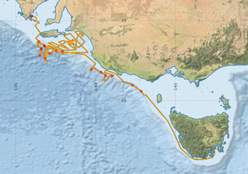
Voyage extents: 43° 41.5' S to 34° 42.4' S 135° 57.9' E to 147° 28.4' E
Marlin Metadata:-
Participants - on ship:-
| Name | Role | Organisation |
|---|---|---|
| Bernadette Heaney | MNF Computing support (SST) | CSIRO Oceans & Atmosphere - Hobart |
| Chris von der Borch | Sedimentologist | Flinders University of South Australia - Flinders Inst. Atmos. Mar. Sci. |
| Daniel Wilkins | Sedimentologist, PhD student | Australian National University |
| Don McKenzie | MNF Voyage Manager | CSIRO Oceans & Atmosphere - Hobart |
| Doreen Rossler | Sedimentologist, PhD student | LIOW |
| John Rodgers | Micropalaeontologist, PhD student | Australian National University |
| Lindsay MacDonald | MNF Electronic support (SST) | CSIRO Oceans & Atmosphere - Hobart |
| Mark Rayner | MNF Hydrochemistry Support (SST) | CSIRO Oceans & Atmosphere - Hobart |
| Michele Spinoccia | Swath mapping support | Geoscience Australia |
| Nigel Craddy | Technician | Australian National University |
| Patrick De Deckker | Chief Investigator | Australian National University |
| Peter Hill | Sedimentologist | Australian National University |
| Sarah Tynan | Sedimentologist, PhD student | Australian National University |
| Stephen Eggins | Geochemist | Australian National University |
| TBC | Sedimentologist | Australian National University |
This list includes those that may have only been on part of the voyage. See voyage reports on 'Reports and Maps' tab for details.
Marine National Facility Reports - plans, summaries and data processing
-
SS200602 Scientific Highlight
- report of the key outputs
-
SS200602 Voyage Plan
- includes objectives, investigator details, proposed data collection, voyage track and equipment to be used.
-
SS200602 Voyage Summary
- includes preliminary results, voyage narrative, types of data collected with C77/ROSCOP codes.
-
SS200602 Underway Data Processing Report
- details of data processing steps, calibration information, instruments used and any issues with the data.
-
SS200602 CTD Data Processing Report
- details of data processing steps, calibration information, instruments used and any issues with the data.
-

Publications, reports and datasets from this voyage.
Journal Article
- De Deckker, P.,Nanson, R. (2023) Submarine canyons and slides in the central-west Otway Basin: their morphology, genesis, links to groundwater discharge and tsunamigenic potential. Australian Journal of Earth Sciences 70 pp18-39. 10.1080/08120099.2022.2125070
- Hill, P. J.,De Deckker†, P.,von der Borch, C.,Murray-Wallace, C. V. (2009) Ancestral Murray River on the Lacepede Shelf, southern Australia: Late Quaternary migrations of a major river outlet and strandline development. Australian Journal of Earth Sciences 56 pp135-157. 10.1080/08120090802546993
- Mojtahid, M.,Michel, E.,De Deckker, P. (2020) From “source to sink” – A new perspective on the past dynamics of the Murray Canyon Group from benthic foraminiferal communities. Marine Micropaleontology 160 pp101877-. 10.1016/j.marmicro.2020.101877
Search for publications, reports and datasets from this and other voyages
Data publishing
This is a list of online datasets hosted by CSIRO. Other processed datasets hosted by collaborating organisations may be found on the 'Metadata' or "Reports, Publications and Maps' tab.
Use the Get data link on the right to extract data using the NCMI Data Trawler.
| Data Stream | Data Summary | Get data | ||||||||||||
|---|---|---|---|---|---|---|---|---|---|---|---|---|---|---|
| ADCP Data |
|
Get Data from Trawler Download netCDF dataset ss200602ADCPnc.zip Data processing report |
||||||||||||
| CTD profile |
|
Get Data from Trawler Download ASCII dataset 4.0/ 1.6 Mb Download netCDF dataset 284/123 Kb Download CTD processing report |
||||||||||||
| Multibeam echosounder |
|
Get Data from Trawler |
||||||||||||
| Underway |
|
Get Data from Trawler |
Deployments by start time:- Click on column header to sort. Use link on 'Deployment' to see full details. Use the CSV button at the bottom to export data (tab delimited).
Search for deployments from this voyage and others
| Deployment | Operation | Station | Cast | Gear | Project | Start and end times | Start Location | End Location | Depth range | Max Depth | Description | |||
|---|---|---|---|---|---|---|---|---|---|---|---|---|---|---|
| Underway System [details] | Air Temperature Sensor-HMP233,Barometer,Fluorometer WS3S-443P,Gyro-Generic SS-NF,Humidity Sensor-HMP233,Licor-UWQ 3708,RM Young 05103 wind monitor,RM Young 05103 wind monitor,RM Young 05103 wind monitor,RM Young Rain Gauge,Seapath 200,Seapath 200,Simrad EA500 Echosounder,ThermoSalinoGraph (TSG)-SS-SN 1777,ThermoSalinoGraph (TSG)-SS-SN 1777 | 125 | 2006-03-01 00:15 | 2006-03-14 19:44 | -34.7265 | 135.9647 | -42.9812 | 147.3765 | ||||||
| Multibeam echosounder [details] | EM300 Multibeam Echosounder | 2006-03-01 00:30 | 2006-03-14 20:42 | -34.7072 | 136.0140 | -42.8870 | 147.3431 | 5397.8 | ||||||
| ADCP Data [details] | RDI Ocean Surveyor Acoustic Doppler current profiler | 125 | 2006-03-01 14:47 | 2006-03-02 01:37 | -36.3172 | 136.4500 | -43.0334 | 147.3759 | 814 | |||||
| CTD Cast [details] | 1 | Cast 1 | CTD 20 - SN 0552,Conductivity CTD 20-SN 2598,Fluorometer CTD 20-Chelsea 88221,Oxygen CTD 20-Becman 527,Pressure CTD 20-SN 75638,Temperature CTD 20-SN 2466 | 125 | 2006-03-01 23:53 | 2006-03-02 01:52 | -36.7781 | 136.5895 | -36.7775 | 136.5907 | 2370 | |||
| ADCP Data [details] | 125 | 2006-03-02 02:17 | 2006-03-04 04:57 | -36.7748 | 136.5958 | -36.6816 | 136.8558 | 814 | ||||||
| CTD Cast [details] | 1 | Cast 2 | CTD 20 - SN 0552,Conductivity CTD 20-SN 2598,Fluorometer CTD 20-Chelsea 88221,Oxygen CTD 20-Becman 527,Pressure CTD 20-SN 75638,Temperature CTD 20-SN 2466 | 125 | 2006-03-02 06:26 | 2006-03-02 10:44 | -37.1752 | 136.4894 | -37.1762 | 136.4868 | 5192 | |||
| CTD Cast [details] | 1 | Cast 3 | CTD 20 - SN 0552,Conductivity CTD 20-SN 2598,Fluorometer CTD 20-Chelsea 88221,Oxygen CTD 20-Becman 527,Pressure CTD 20-SN 75638,Temperature CTD 20-SN 2466 | 125 | 2006-03-03 03:53 | 2006-03-03 08:05 | -37.3548 | 136.8323 | -37.3551 | 136.8328 | 5220 | |||
| ADCP Data [details] | 125 | 2006-03-04 06:13 | 2006-03-10 01:33 | -36.5529 | 136.7831 | -37.0590 | 137.1990 | 271 | ||||||
| CTD Cast [details] | 1 | Cast 4 | CTD 20 - SN 0552,Conductivity CTD 20-SN 2598,Fluorometer CTD 20-Chelsea 88221,Oxygen CTD 20-Becman 527,Pressure CTD 20-SN 75638,Temperature CTD 20-SN 2466 | 125 | 2006-03-04 07:03 | 2006-03-04 07:29 | -36.5960 | 136.7997 | -36.5955 | 136.8001 | 338 | |||
| CTD Cast [details] | 1 | Cast 5 | CTD 20 - SN 0552,Conductivity CTD 20-SN 2598,Fluorometer CTD 20-Chelsea 88221,Oxygen CTD 20-Becman 527,Pressure CTD 20-SN 75638,Temperature CTD 20-SN 2466 | 125 | 2006-03-04 23:55 | 2006-03-05 00:22 | -36.9081 | 137.5260 | -36.9058 | 137.5273 | 324 | |||
| ADCP Data [details] | 125 | 2006-03-10 01:56 | 2006-03-11 03:06 | -37.0519 | 137.1167 | -36.9101 | 137.8677 | 814 | ||||||
| ADCP Data [details] | 125 | 2006-03-11 03:23 | 2006-03-11 16:33 | -36.9331 | 137.9215 | -37.9449 | 139.8052 | 271 | ||||||
| ADCP Data [details] | 125 | 2006-03-11 17:14 | 2006-03-12 02:40 | -38.0476 | 139.7425 | -38.1937 | 140.2743 | 814 | ||||||
| ADCP Data [details] | 125 | 2006-03-12 03:02 | 2006-03-12 05:12 | -38.2300 | 140.3413 | -38.3839 | 140.6394 | 191 | ||||||
| ADCP Data [details] | 125 | 2006-03-12 05:39 | 2006-03-12 12:39 | -38.4510 | 140.6136 | -38.4734 | 140.8782 | 814 | ||||||
| ADCP Data [details] | 125 | 2006-03-12 13:19 | 2006-03-13 01:59 | -38.4607 | 141.0191 | -38.9856 | 142.2357 | 223 | ||||||
| ADCP Data [details] | 125 | 2006-03-13 02:21 | 2006-03-13 06:11 | -39.0398 | 142.3049 | -39.3515 | 142.8001 | 686 | ||||||
| ADCP Data [details] | 125 | 2006-03-13 06:36 | 2006-03-14 19:06 | -39.4218 | 142.8526 | -43.0334 | 147.3759 | 230 | ||||||