Voyage details and related metadata, reports, events and data.
SS 08/2005
(alternative identifier: SS200508)
- is a Marine National Facility ![]() voyage
voyage
Period: 2005-09-28 05:00 to 2005-10-20 01:00 UTC
Duration: 21.83 days
From: Fremantle To: Fremantle
Region: East Mentelle Basin off Western Austrailian Coast
Ship: Southern Surveyor [details]
Description:
Southern Surveyor Research Voyage SS200508: GA Survey 293: Marine National Facility Research charter by Geoscience Australia and Department of Environment and Heritage.
Principal Investigator: Dr Andrew Heap
Characterising benthic habitats and sedimentary processes of southwest Australian margin, including developing an understanding of the petroleum potential of the East Mentelle Basin.
28 September to 20 October 2005.
Leader: Dr Andrew Heap (GA)
Project: National Facility External Users: A. Heap (Geoscience Australia) [details]
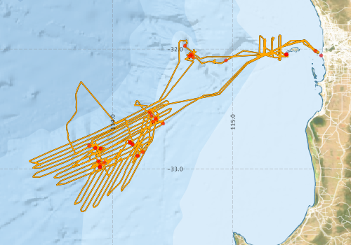
Voyage extents: 33° 21.4' S to 31° 53.1' S 113° 18.2' E to 115° 43.2' E Get voyage track shapefile Get CSV
Marlin Metadata:-
Participants - on ship:-
| Name | Role | Organisation |
|---|---|---|
| Andrew Heap | Chief Investigator | Geoscience Australia |
| Cameron Mitchell | Swath processor/GIS | Geoscience Australia |
| Colin Tindall | Geological Technician | Geoscience Australia |
| Craig Wintle | Mechanical Technician | Geoscience Australia |
| Drew Mills | Electronics (Voyage Manager) | CSIRO Oceans & Atmosphere - Hobart |
| Emma Mathews | Scientist/Database | Geoscience Australia |
| Franz Villagran | Electronics Technician | Geoscience Australia |
| Hiski Kippo | Computing Support | CSIRO Oceans & Atmosphere - Hobart |
| Ian Atkinson | Electronics Technician | Geoscience Australia |
| Irina Borissova | Scientist/GIS/Database | Geoscience Australia |
| Jane Blevin | Scientist/watch leader | Geoscience Australia |
| Julian Finn | Biologist | Museum Victoria |
| Karen Gowlett-Holmes | Biologist | CSIRO Oceans & Atmosphere - Hobart |
| Michele Spinoccia | Swath processor | Geoscience Australia |
| Petar Vujovic | Geological Technician | Geoscience Australia |
This list includes those that may have only been on part of the voyage. See voyage reports on 'Reports and Maps' tab for details.
Marine National Facility Reports - plans, summaries and data processing
-
SS200508 Scientific Highlight
- report of the key outputs
-
SS200508 Underway Data Processing Report
- details of data processing steps, calibration information, instruments used and any issues with the data.
-
SS200508 Voyage Summary
- includes preliminary results, voyage narrative, types of data collected with C77/ROSCOP codes.
-
SS200508 Voyage Plan
- includes objectives, investigator details, proposed data collection, voyage track and equipment to be used.
-

Publications, reports and datasets from this voyage.
Dataset
- Spinoccia, M. (2013) Mentelle Basin Survey (GA-0293/SS08/2005) - Bathymetry grids. Geoscience Australia, Canberra. 10.4225/25/562ec3c2c54ad
Journal Article
- Greaves, Elizabeth,Meißner, Karin,Wilson, Robin (2011) New Laonice species (Polychaeta: Spionidae) from western and northern Australia. Zootaxa 2903 pp1-. 10.11646/zootaxa.2903.1.1
- Lucieer, Vanessa,Flukes, Emma,Monk, Jacquomo,Walsh, Peter (2024) Geomorphometric maps of Australia’s Marine Park estate and their role in improving the integrated monitoring and management of marine ecosystems. Frontiers in Marine Science 10 pp-. 10.3389/fmars.2023.1302108
Report
- Heap, A.D., Edwards, J., Fountain, L., Spinoccia, M., Hughes, M.G. (2008) Geomorphology, Sedimentology and Stratigraphy of Submarine Canyons on the SW Australian Slope: RV Southern Surveyor, September – October 2005. Record 2008/016. Geoscience Australia, Canberra. External link to reference
Search for publications, reports and datasets from this and other voyages
Data publishing
This is a list of online datasets hosted by CSIRO. Other processed datasets hosted by collaborating organisations may be found on the 'Metadata' or "Reports, Publications and Maps' tab.
Use the Get data link on the right to extract data using the NCMI Data Trawler.
| Data Stream | Data Summary | Get data | ||||||||||||||
|---|---|---|---|---|---|---|---|---|---|---|---|---|---|---|---|---|
| ADCP Data |
|
Get Data from Trawler Download netCDF dataset ss200508ADCPnc.zip Data processing report |
||||||||||||||
| CTD profile |
|
Get Data from Trawler Download ASCII dataset ss200508CTDcsv.zip Download NetCDF dataset ss200508CTDnc.zip Download Processing Report ss200508ctd.pdf |
||||||||||||||
| Multibeam echosounder |
|
Get Data from Trawler |
||||||||||||||
| Underway |
|
Get Data from Trawler |
Deployments by start time:- Click on column header to sort. Use link on 'Deployment' to see full details. Use the CSV button at the bottom to export data (tab delimited).
Search for deployments from this voyage and others
| Deployment | Operation | Station | Cast | Gear | Project | Start and end times | Start Location | End Location | Depth range | Max Depth | Description | |||
|---|---|---|---|---|---|---|---|---|---|---|---|---|---|---|
| Multibeam echosounder [details] | EM300 Multibeam Echosounder | 2005-09-28 05:21 | 2005-10-20 00:42 | -32.0540 | 115.7368 | -32.0559 | 115.7154 | 5125.5 | ||||||
| Underway System [details] | Air Temperature Sensor-HMP233,Barometer,Fluorometer WS3S-443P,Gyro-Generic SS-NF,Humidity Sensor-HMP233,Licor-UWQ 3708,RM Young 05103 wind monitor,RM Young 05103 wind monitor,RM Young 05103 wind monitor,Seapath 200,Seapath 200,Simrad EA500 Echosounder,ThermoSalinoGraph (TSG),ThermoSalinoGraph (TSG)-SS-SN 1777 | 2230 | 2005-09-28 05:51 | 2005-10-19 23:14 | -32.0145 | 115.6894 | -31.9553 | 115.6344 | ||||||
| ADCP Data [details] | RDI Ocean Surveyor Acoustic Doppler current profiler | 2230 | 2005-09-28 12:52 | 2005-10-08 03:07 | -32.0945 | 114.9437 | -32.4742 | 113.6976 | 814 | |||||
| CTD Cast [details] | 1 | Cast 1 | CTD 20 - SN 0552,Conductivity CTD 20-SN 2594,Licor CTD 20-SN 5730,Oxygen CTD 20-Becman 527,Pressure CTD 20-SN 75638,Temperature CTD 20-SN 2466,Transmissometer CTD 20-C Star | 2230 | 2005-09-28 16:53 | 2005-09-28 17:37 | -32.0601 | 114.6391 | -32.0593 | 114.6406 | 1382 | |||
| CTD Cast [details] | 1 | Cast 2 | CTD 20 - SN 0552,Conductivity CTD 20-SN 2594,Licor CTD 20-SN 5730,Oxygen CTD 20-Becman 527,Pressure CTD 20-SN 75638,Temperature CTD 20-SN 2466,Transmissometer CTD 20-C Star | 2230 | 2005-10-02 07:30 | 2005-10-02 09:19 | -32.8313 | 113.9012 | -32.8387 | 113.9056 | 2428 | |||
| CTD Cast [details] | 1 | Cast 5 | CTD 20 - SN 0552,Conductivity CTD 20-SN 2594,Licor CTD 20-SN 5730,Oxygen CTD 20-Becman 527,Pressure CTD 20-SN 75638,Temperature CTD 20-SN 2466,Transmissometer CTD 20-C Star | 2230 | 2005-10-08 19:42 | 2005-10-08 21:04 | -32.8247 | 113.8559 | -32.8261 | 113.8551 | 2602 | |||
| CTD Cast [details] | 1 | Cast 7 | CTD 20 - SN 0552,Conductivity CTD 20-SN 2594,Licor CTD 20-SN 5730,Oxygen CTD 20-Becman 527,Pressure CTD 20-SN 75638,Temperature CTD 20-SN 2466,Transmissometer CTD 20-C Star | 2230 | 2005-10-12 07:13 | 2005-10-12 09:00 | -32.9838 | 113.8947 | -32.9885 | 113.8997 | 2178 | |||
| CTD Cast [details] | 1 | Cast 8 | CTD 20 - SN 0552,Conductivity CTD 20-SN 2594,Licor CTD 20-SN 5730,Oxygen CTD 20-Becman 527,Pressure CTD 20-SN 75638,Temperature CTD 20-SN 2466,Transmissometer CTD 20-C Star | 2230 | 2005-10-14 03:35 | 2005-10-14 05:51 | -32.7820 | 114.1480 | -32.7816 | 114.1474 | 1938 | |||
| CTD Cast [details] | 1 | Cast 9 | CTD 20 - SN 0552,Conductivity CTD 20-SN 2594,Licor CTD 20-SN 5730,Oxygen CTD 20-Becman 527,Pressure CTD 20-SN 75638,Temperature CTD 20-SN 2466,Transmissometer CTD 20-C Star | 2230 | 2005-10-19 01:12 | 2005-10-19 01:18 | -32.0428 | 115.4501 | -32.0422 | 115.4518 | 20 | |||
| Sediment Sampling [details] | SS082005/19BC01 | 2230 | -32.9873 | 113.8940 | ||||||||||
| Sediment Sampling [details] | SS082005/26GC21 | 2230 | -31.9722 | 114.6026 | ||||||||||
| Sediment Sampling [details] | SS082005/18GC15 | 2230 | -32.9675 | 113.8980 | ||||||||||
| Sediment Sampling [details] | SS082005/28GC22 | 2230 | -32.0651 | 114.6681 | ||||||||||
| Sediment Sampling [details] | SS082005/03GC12 | 2230 | -32.8306 | 113.9008 | ||||||||||
| Sediment Sampling [details] | SS082005/09GC06 | 2230 | -32.8919 | 114.2058 | ||||||||||
| Sediment Sampling [details] | SS082005/04GC01 | 2230 | -32.6071 | 114.3373 | ||||||||||
| Sediment Sampling [details] | SS082005/24GC18 | 2230 | -32.7739 | 114.1413 | ||||||||||
| Sediment Sampling [details] | SS082005/12GC13 | 2230 | -32.8262 | 113.8564 | ||||||||||
| Sediment Sampling [details] | SS082005/25GC19 | 2230 | -32.8600 | 114.2503 | ||||||||||
| Sediment Sampling [details] | SS082005/09GC07 | 2230 | -32.8924 | 114.2086 | ||||||||||
| Sediment Sampling [details] | SS082005/08GC05 | 2230 | -32.5545 | 114.3232 | ||||||||||
| Sediment Sampling [details] | SS082005/10GC08 | 2230 | -32.7966 | 114.1655 | ||||||||||
| Sediment Sampling [details] | SS082005/05GC02 | 2230 | -32.5874 | 114.3627 | ||||||||||
| Sediment Sampling [details] | SS082005/10GC09 | 2230 | -32.7970 | 114.1661 | ||||||||||
| Sediment Sampling [details] | SS082005/27GC20 | 2230 | -32.6215 | 114.4212 | ||||||||||
| Sediment Sampling [details] | SS082005/01GR01 | 2230 | -32.0448 | 115.4478 | ||||||||||
| Sediment Sampling [details] | SS082005/01GR02 | 2230 | -32.0455 | 115.4453 | ||||||||||
| Sediment Sampling [details] | SS082005/01GR03 | 2230 | -32.0453 | 115.4453 | ||||||||||
| Sediment Sampling [details] | SS082005/17GC14 | 2230 | -32.9357 | 113.8870 | ||||||||||
| Sediment Sampling [details] | SS082005/21GC17 | 2230 | -32.9466 | 113.9303 | ||||||||||
| Sediment Sampling [details] | SS082005/02GC24 | 2230 | -32.0430 | 114.6583 | ||||||||||
| Sediment Sampling [details] | SS082005/06GC03 | 2230 | -32.5762 | 114.3563 | ||||||||||
| Sediment Sampling [details] | SS082005/11GC10 | 2230 | -32.8058 | 113.8048 | ||||||||||
| Sediment Sampling [details] | SS082005/19GC16 | 2230 | -32.9875 | 113.8941 | ||||||||||
| Sediment Sampling [details] | SS082005/07GC04 | 2230 | -32.5284 | 114.3074 | ||||||||||
| Sediment Sampling [details] | SS082005/23GC18A | 2230 | -32.7824 | 114.1475 | ||||||||||
| Sediment Sampling [details] | SS082005/16GC11 | 2230 | -32.9394 | 113.8800 | ||||||||||
| Sediment Sampling [details] | SS082005/02GC23 | 2230 | -32.0515 | 114.6485 | ||||||||||