Voyage details and related metadata, reports, events and data.
SS 11/2004
(alternative identifier: SS200411)
- is a Marine National Facility ![]() voyage
voyage
Period: 2004-10-26 21:00 to 2004-11-15 20:00 UTC
Duration: 19.96 days
From: Nuku'alofa To: Apia
Region: the northern Tofua Arc, Pacific Ocean, Coral Sea
Ship: Southern Surveyor [details]
Description:
Voyage SS 11/2004, NOTOVE-2004 (Northern Tonga Vents Expedition) will continue to investigate the
Submarine hydrothermal plume activity and petrology of the northern Tofua Arc, Tonga, complimenting the work of SS 02/2003.
Specific objectives are:
1. To perform the first detailed, high-resolution, swathmap bathymetric surveys
of individual submarine volcanoes of the northern Tofua Arc between 20o 50'S
and 15o 20'S, using the Kongsberg EM300 system;
2. To perform the first detailed, high-resolution swathmap bathymetric survey
of the Fonualei Rifts, a nascent backarc basin immediately adjacent and northwest
of Fonualei;
3. Dredge igneous rock targets identified on these submarine volcanoes, and the
floor of the Fonualei Rifts, in order to recover fresh glassy rock samples for
detailed age studies and chemical analysis, particularly of volatile elements and
compounds, radiogenic and stable isotopic characteristics.
4. Dredge hydrothermal sulfide-rich and altered rock samples for studies of
base and precious metal mineralisation;
5. To explore with the transmissometer/nephelometer-equipped CTD rosette
for hydrothermal plume activity in these volcanoes and rifts, and to recover
water samples for immediate analysis on board and subsequent shore-based
laboratory analysis.
Taken from SS11/2004 Voyage Plan.
Leader: J. Arculus (ANU)
Project: National Facility External Users: R. J. Arculus (ANU) [details]
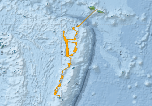
Voyage extents: 21° 07.8' S to 13° 44.5' S 175° 37.4' W to 171° 59.7' W Get voyage track shapefile Get CSV
Marlin Metadata:-
Participants - on ship:-
| Name | Role | Organisation |
|---|---|---|
| Bob Beattie | Computing Support | CSIRO Oceans & Atmosphere - Hobart |
| Cameron Buchanan | swath mapping | Geoscience Australia |
| Chris Dale | petrology-isotopes | University of Durham (UK) |
| Jeff Cordell | Electronics Support | CSIRO Oceans & Atmosphere - Hobart |
| Kurt Worden | petrology/tectonics | Geoscience Australia |
| Lauren Cooper | petrology/melt incl | Boston University |
| Mitzy Pepper | petrology/zoology | Australian National University |
| Niccole Mikkelson | petrology | Australian National University |
| Nicole Keller | petrology/volatiles | Australian National University |
| Rennie Vaimo'unga | Tonga Observer | Tonga |
| Richard Arculus | CI petrology/tectonics | ANU-Earth & Marine Sciences |
| Sam Burgess | zoology | Australian National University |
| Samantha Hammond | petrology/Li isotopes | Open University (UK), |
| Tim Worthington | petrology/tectonics | Christian-Albrechts-Universitat zu Kiel (Germany) |
This list includes those that may have only been on part of the voyage. See voyage reports on 'Reports and Maps' tab for details.
Marine National Facility Reports - plans, summaries and data processing
-
SS200411 Scientific Highlight
- report of the key outputs
-
SS200411 Underway Data Processing Report
- details of data processing steps, calibration information, instruments used and any issues with the data.
-
SS200411 Voyage Summary
- includes preliminary results, voyage narrative, types of data collected with C77/ROSCOP codes.
-
SS200411 Voyage Plan
- includes objectives, investigator details, proposed data collection, voyage track and equipment to be used.
-

Publications, reports and datasets from this voyage.
Conference Proceedings
- Arculus, R. J. (2019) Northern Tonga Arc and Fonualei Rifts: initial results from the NoToVE (SS11/2004) Research Voyage. ASEG Extended Abstracts 2006 pp1-5. 10.1071/aseg2006ab150
Dataset
- Plank, T., Arculus, R., (2018) Petrology Samples from the Submarine Tonga Arc Collected during the TELVE and NoToVE Cruises, Version 1.0. Interdisciplinary Earth Data Alliance (IEDA) 10.1594/ieda/100743
Journal Article
- Cooper, Lauren B.,Plank, Terry,Arculus, Richard J.,Hauri, Erik H.,Hall, Paul S.,Parman, Stephen W. (2010) High‐Ca boninites from the active Tonga Arc. Journal of Geophysical Research: Solid Earth 115 pp-. 10.1029/2009JB006367
- Hinchliffe, Charles,Smith, James A.,Everett, Jason D.,Falster, Daniel S.,Lara-Lopez, Ana,Miskiewicz, Anthony G.,Richardson, Anthony J.,Schilling, Hayden T.,Suthers, Iain M. (2021) Modelling the distribution of larval fish in a western boundary current using a multi-voyage database. Reviews in Fish Biology and Fisheries 31 pp399-415. 10.1007/s11160-021-09647-x
- Keller, Nicole S.,Arculus, Richard J.,Hermann, Jörg,Richards, Simon (2008) Submarine back-arc lava with arc signature: Fonualei Spreading Center, northeast Lau Basin, Tonga. Journal of Geophysical Research: Solid Earth 113 pp-. 10.1029/2007jb005451
- Kendrick, Mark A.,Arculus, Richard J.,Danyushevsky, Leonid V.,Kamenetsky, Vadim S.,Woodhead, Jon D.,Honda, Masahiko (2014) Subduction-related halogens (Cl, Br and I) and H2O in magmatic glasses from Southwest Pacific Backarc Basins. Earth and Planetary Science Letters 400 pp165-176. 10.1016/j.epsl.2014.05.021
- Kendrick, Mark A.,Danyushevsky, Leonid V.,Falloon, Trevor J.,Woodhead, Jon D.,Arculus, Richard J.,Ireland, Trevor (2020) SW Pacific arc and backarc lavas and the role of slab-bend serpentinites in the global halogen cycle. Earth and Planetary Science Letters 530 pp115921-. 10.1016/j.epsl.2019.115921
- Sleeper, Jonathan D.,Martinez, Fernando (2016) Geology and kinematics of the Niuafo'ou microplate in the northern Lau Basin. Journal of Geophysical Research: Solid Earth 121 pp4852-4875. 10.1002/2016jb013051
- Sleeper, Jonathan D.,Martinez, Fernando,Arculus, Richard (2016) The Fonualei Rift and Spreading Center: Effects of ultraslow spreading and arc proximity on back‐arc crustal accretion. Journal of Geophysical Research: Solid Earth 121 pp4814-4835. 10.1002/2016jb013050
- Smith, J., Miskiewicz, A., Beckley, L., Everett, J., Garcia, V., Gray, C., Holliday, D., Jordan, A., Keane, J., Lara-Lopez, A., Leis, J., Matis, P., Muhling, B., Neira, F., Richardson, A., Smith, K., Swadling, K., Syahailatua, A., Taylor, M., van Ruth, P., Ward, T., Suthers, I. (2018) A database of marine larval fish assemblages in Australian temperate and subtropical waters, Scientific Data, 5, 16 Oct 2018, pages 180207 10.1038/sdata.2018.207
Search for publications, reports and datasets from this and other voyages
Data publishing
This is a list of online datasets hosted by CSIRO. Other processed datasets hosted by collaborating organisations may be found on the 'Metadata' or "Reports, Publications and Maps' tab.
Use the Get data link on the right to extract data using the NCMI Data Trawler.
| Data Stream | Data Summary | Get data | ||||||||||||||
|---|---|---|---|---|---|---|---|---|---|---|---|---|---|---|---|---|
| ADCP Data |
|
Get Data from Trawler Download dataset 8 / 1.8 Mb Processing report for this dataset |
||||||||||||||
| CTD profile | No data |
Processing Note: SS200411ctd.pdf ss200411CTDnc.zip |
||||||||||||||
| Multibeam echosounder |
|
Get Data from Trawler |
||||||||||||||
| Underway |
|
Get Data from Trawler |
Deployments by start time:- Click on column header to sort. Use link on 'Deployment' to see full details. Use the CSV button at the bottom to export data (tab delimited).
Search for deployments from this voyage and others
| Deployment | Operation | Station | Cast | Gear | Project | Start and end times | Start Location | End Location | Depth range | Max Depth | Description | |||
|---|---|---|---|---|---|---|---|---|---|---|---|---|---|---|
| Underway System [details] | Air Temperature Sensor-HMP233,Barometer,Fluorometer WS3S-026,Gyro-Generic SS-NF,Humidity Sensor-HMP233,Licor-UWQ 3708,RM Young 05103 wind monitor,RM Young 05103 wind monitor,Seapath 200,Seapath 200,Simrad EA500 Echosounder,ThermoSalinoGraph (TSG)-SS-SN 1777,ThermoSalinoGraph (TSG)-SS-SN 1777 | 1707 | 2004-10-26 21:00 | 2004-11-15 16:37 | -21.1295 | 184.8192 | -13.7422 | 188.0048 | ||||||
| Multibeam echosounder [details] | EM300 Multibeam Echosounder | 2004-10-26 21:59 | 2004-11-15 07:37 | -21.0145 | 184.8240 | -14.8725 | 186.7039 | 3493.6 | ||||||
| ADCP Data [details] | RDI VM-150 Acoustic Doppler current profiler | 1707 | 2004-10-27 00:20 | 2004-11-15 05:00 | -20.7990 | 184.5380 | -15.1310 | 186.4420 | 344.8 | |||||