Voyage details and related metadata, reports, events and data.
SS 01/2003
(alternative identifier: SS200301)
- is a Marine National Facility ![]() voyage
voyage
Period: 2003-02-21 00:00 to 2003-03-13 00:00 UTC
Duration: 20.00 days
From: Hobart To: Auckland
Region: Norfolk Ridge; Loyalty Ridge; Three Kings Rise.
Ship: Southern Surveyor [details]
Description: Dredging of the scarps (rather than the Eocene volcanic peaks) of the Norfolk and Loyalty Ridges and Three Kings Rise (near the boundary of the Tasman Sea, Coral Sea and the Western Pacific Ocean). The dredge sites will hopefully yield Cretaceous-Palaeocene subduction-related volcanic rocks, and perhaps even fragments of the hypothesised most easterly continental crust of Australia rifted from the eastern Lord Howe Rise in the Cretaceous.
Leader: Prof Tony Crawford (Tas Uni)
Project: National Facility External Users: T. Crawford (University of Tasmania) [details]
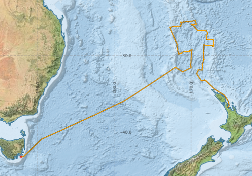
Voyage extents: 43° 15.8' S to 25° 24.5' S 147° 48.2' E to 174° 57.8' E Get voyage track shapefile Get CSV
Marlin Metadata:-
Participants - on ship:-
| Name | Role | Organisation |
|---|---|---|
| Andrew Hislop | Engineering tech support | Geoscience Australia |
| Bob Beattie | Computing | CSIRO Oceans & Atmosphere - Hobart |
| Jeff Cordell | Manager/Electronics | CSIRO Oceans & Atmosphere - Hobart |
| John Stratton | Dredging specialist | Geoscience Australia |
| Lyndon O'Grady | Dredging and tech support | Geoscience Australia |
| Michael Baker | PhD student | University of Tasmania - Hobart |
| Michel Allenbach | Sedimentology | University of New Caledonia |
| Patrick Quilty | Micropalaeontology | University of Tasmania - Hobart |
| Phil O'Brien | Marine geology | Geoscience Australia |
| Rick Herzer | Marine geophys/tectonics | Institute of Geological and Nuclear Sciences, NZ |
| Sebastien Meffre | Petrology/tectonics | University of Tasmania - Hobart |
| Tony Crawford | CI Petrology, tectonics | University of Tasmania - Hobart |
This list includes those that may have only been on part of the voyage. See voyage reports on 'Reports and Maps' tab for details.
Marine National Facility Reports - plans, summaries and data processing
-
SS200301 Voyage Plan
- includes objectives, investigator details, proposed data collection, voyage track and equipment to be used.
-
SS200301 Underway Data Processing Report
- details of data processing steps, calibration information, instruments used and any issues with the data.
-
SS200301 Voyage Summary
- includes preliminary results, voyage narrative, types of data collected with C77/ROSCOP codes.
-

Search for publications, reports and datasets from this and other voyages
Data publishing
This is a list of online datasets hosted by CSIRO. Other processed datasets hosted by collaborating organisations may be found on the 'Metadata' or "Reports, Publications and Maps' tab.
Use the Get data link on the right to extract data using the NCMI Data Trawler.
| Data Stream | Data Summary | Get data | ||||||||||||
|---|---|---|---|---|---|---|---|---|---|---|---|---|---|---|
| Multibeam echosounder | No data | |||||||||||||
| Underway |
|
Get Data from Trawler |
Deployments by start time:- Click on column header to sort. Use link on 'Deployment' to see full details. Use the CSV button at the bottom to export data (tab delimited).
Search for deployments from this voyage and others
| Deployment | Operation | Station | Cast | Gear | Project | Start and end times | Start Location | End Location | Depth range | Max Depth | Description | |||
|---|---|---|---|---|---|---|---|---|---|---|---|---|---|---|
| Underway System [details] | Air Temperature Sensor-HMP233,Barometer,Fluorometer WS3S-443P,GPS-Generic SS-NF,GPS-Generic SS-NF,Gyro-Generic SS-NF,Humidity Sensor-HMP233,Licor-UWQ 3708,RM Young 05103 wind monitor,RM Young 05103 wind monitor,RM Young 05103 wind monitor,Ships log,Simrad EA500 Echosounder,ThermoSalinoGraph (TSG)-SS-SN 1777,ThermoSalinoGraph (TSG)-SS-SN 1777 | 1706 | 2003-02-21 05:05 | 2003-03-12 20:30 | -43.2475 | 147.8040 | -36.8378 | 174.7904 | ||||||