Survey details and related metadata, reports, events and data.
SS 03/99 (alternative identifier: SS199903)
Period: 1999-07-16 00:00 to 1999-08-02 00:00 UTC
Duration: 17.00 days
From: Hobart To: Hobart
Region: Tasman Sea; Waters off Tasmania's east coast.
Ship: Southern Surveyor [details]
Description:
This information was taken from the Cruise Plan
Biomass of the orange roughy and study of its deep-water seamount habitat off the east coast of Tasmania.
The orange roughy fishery remains the most valuable component of the South-East Fishery (SEF, and the validity of the current estimates of stock status need to be clarified
Cruise Objectives
1.To assess the biomass of orange roughy based on acoustic surveys on the Eastern Zone fishing grounds (St Helens and St Patricks) during the spawning period using industry vessel acoustics over an extended 4 week period and the CSIRO acoustic package during the anticipated peak spawning period.
2.To compare the sensitivity and precision of acoustic surveys using scientific vessel-mounted and towed-body acoustics and industry vessel-mounted acoustics at various frequencies.
3.To further develop the acoustic method by improving the multi-frequency technique for species identification: sound absorption coefficient and in-situ target strengths.
4.Map significant deep-water seabed habitats using the towed deep-water video camera and towed acoustic system and further develop the technique with experiments in shallow water.
5.Identify the composition of distinct bio-acoustic scattering layers with underway multi-frequency acoustic data and target sampling with a pelagic trawl capable of depth stratified sampling.
6.To conduct a preliminary survey of the orange roughy on the South Tasman Rise spawning hill.
Leader: R. Kloser (CSIRO)
Project: Orange Roughy Assessment 1997-1999 [details]
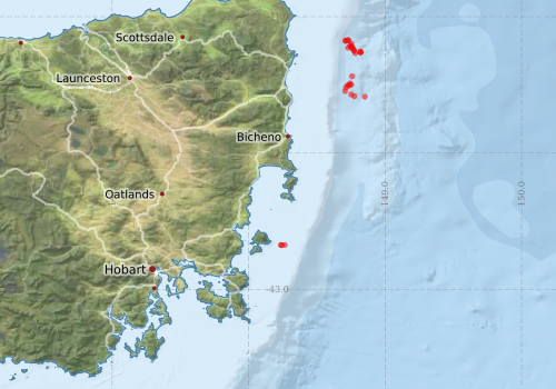
Voyage extents: 43° 20.0' S to 41° 21.2' S 147° 21.9' E to 149° 00.0' E
Marlin Metadata:-
Metadata from OBIS Australia datasets:- biological data is published via the OBIS-AU IPT server and delivered to one or more of OBIS, ALA and GBIF
Download from OBIS Australia IPT View at - Ocean Biodiversity Information System (OBIS) Atlas of Living Australia (ALA) GBIF
Download from OBIS Australia IPT View at - Ocean Biodiversity Information System (OBIS)
Participants - on ship:-
| Name | Role | Organisation |
|---|---|---|
| Alan Williams | Watch leader | CMR |
| Denise Mackay | CMR | |
| Don McKenzie | Vessel Operations/CTD | CMR |
| Harry Higgins | CMR | |
| Jeanette O'Sullivan | CMR | |
| Jeff Cordell | Electronics | CMR |
| Jeremy Prince | Co-investigator | BioSpeherics |
| Karen Gowlett-Holmes | Benhic specialist | CMR |
| Mark Lewis | Gear | CMR |
| Mattt Sherlock | Electronics | CMR |
| Peter Hill | Geologist/Swath | AGSO |
| Rudy Kloser | Cheif Scientists | CMR |
| Tim Ryan | Data manager | CMR |
This list includes those that may have only been on part of the voyage. See voyage reports on 'Reports and Maps' tab for details.
Marine National Facility Reports - plans, summaries and data processing
-
SS199903 Voyage Summary
- includes preliminary results, voyage narrative, types of data collected with C77/ROSCOP codes.
-
SS199903 Voyage Plan
- includes objectives, investigator details, proposed data collection, voyage track and equipment to be used.
-

Publications, reports and datasets from this voyage.
IPT Resource
- Australian National Fish Collection (ANFC) (Darwin Core Archive) External link to reference
- Global benthic biogeographical regions and macroecological drivers for ophiuroids [Data set] (Darwin Core Archive) External link to reference
Journal Article
- Kloser, Rudy J.,Sutton, Caroline,Krusic-Golub, Kyne,Ryan, Tim E. (2015) Indicators of recovery for orange roughy (Hoplostethus atlanticus) in eastern Australian waters fished from 1987. Fisheries Research 167 pp225-235. 10.1016/j.fishres.2015.02.017
- Staples, David A. (2007), A new species of Colossendeis (Pycnogonida : Colossendeidae) together with records from Australian and New Zealand waters. Memoirs of Museum Victoria, 64: pp. 79-94. 10.24199/j.mmv.2007.64.8
- Verhoeff, Tristan Joseph (2025) Dallithyris and Liothyrella from southeastern Australia with description of a new species of Liothyrella (Brachiopoda: Terebratulidae). Australian Journal of Taxonomy pp1-21. 10.54102/ajt.96zkl
Search for publications, reports and datasets from this and other voyages
Data publishing
This is a list of online datasets hosted by CSIRO. Other processed datasets hosted by collaborating organisations may be found on the 'Metadata' or "Reports, Publications and Maps' tab.
Use the Get data link on the right to extract data using the NCMI Data Trawler.
| Data Stream | Data Summary | Get data | ||||||||||
|---|---|---|---|---|---|---|---|---|---|---|---|---|
| Marine biodiversity observations and/or samples |
|
Get Data from Trawler |
Deployments by start time:- Click on column header to sort. Use link on 'Deployment' to see full details. Use the CSV button at the bottom to export data (tab delimited).
Search for deployments from this voyage and others
| Deployment | Operation | Station | Cast | Gear | Project | Start and end times | Start Location | End Location | Depth range | Max Depth | Description | |||
|---|---|---|---|---|---|---|---|---|---|---|---|---|---|---|
| CTD Cast [details] | 1 | Cast | 1999-07-15 21:39 | 1999-07-16 02:21 | -43.6717 | 148.2483 | ||||||||
| Catch [details] | 7 | Smith-McIntyre Grab 0.1cu.m. | 1999-07-17 02:00 | -42.6750 | 148.2417 | |||||||||
| Catch [details] | 8 | Smith-McIntyre Grab 0.1cu.m. | 1999-07-17 02:10 | -42.6733 | 148.2367 | |||||||||
| Video [details] | 9 | 1999-07-17 07:30 | 1999-07-17 08:31 | -42.6733 | 148.2650 | -42.6783 | 148.2317 | |||||||
| Catch [details] | 19 | Mid Ocean Open Close - MIDOC. | 1999-07-20 16:09 | -41.2667 | 148.7817 | |||||||||
| CTD Cast [details] | 20 | Cast | 1999-07-20 19:59 | |||||||||||
| Catch [details] | 25 | Benthic sled | 1999-07-21 14:55 | 1999-07-21 15:05 | -41.4983 | 148.7517 | ||||||||
| Catch [details] | 26 | 1999-07-21 16:33 | 1999-07-21 16:47 | -41.5050 | 148.7367 | -41.5067 | 148.7533 | |||||||
| Video [details] | 29 | 1999-07-22 09:37 | 1999-07-22 11:00 | -41.5450 | 148.7067 | -41.5133 | 148.7300 | |||||||
| Video [details] | 30 | 1999-07-22 12:57 | 1999-07-22 15:36 | -41.4800 | 148.7550 | |||||||||
| Catch [details] | 31 | 1999-07-22 17:04 | 1999-07-22 17:55 | -41.4750 | 148.7450 | |||||||||
| CTD Cast [details] | 32 | Cast | 1999-07-22 20:15 | 1999-07-22 20:58 | ||||||||||
| Catch [details] | 33 | Mid Ocean Open Close - MIDOC. | 1999-07-22 22:10 | 1999-07-23 01:05 | -41.5700 | 148.7517 | ||||||||
| Catch [details] | 37 | 1999-07-23 13:59 | 1999-07-23 16:44 | -41.4367 | 148.7583 | -41.5550 | 148.7517 | |||||||
| Catch [details] | 38 | 1999-07-23 18:46 | 1999-07-23 19:02 | -41.4900 | 148.7433 | -41.5017 | 148.7467 | |||||||
| Catch [details] | 41 | 1999-07-24 05:17 | 1999-07-24 06:08 | -41.2283 | 148.7617 | -41.2183 | 148.7183 | |||||||
| Video [details] | 48 | 1999-07-25 07:01 | 1999-07-25 11:15 | -41.5033 | 148.7250 | -41.5183 | 148.7150 | |||||||
| CTD Cast [details] | 59 | Cast | 1999-07-27 00:00 | 1999-07-27 00:58 | ||||||||||
| Catch [details] | 60 | Mid Ocean Open Close - MIDOC. | 1999-07-27 02:37 | 1999-07-27 02:37 | -41.1983 | 148.7517 | ||||||||
| Catch [details] | 61 | Mid Ocean Open Close - MIDOC. | 1999-07-27 04:01 | 1999-07-27 05:58 | -41.1700 | 148.7300 | -41.2667 | 148.7933 | ||||||
| Catch [details] | 62 | 1999-07-27 07:38 | 1999-07-27 07:52 | -41.2133 | 148.7517 | -41.2067 | 148.7483 | |||||||
| Catch [details] | 63 | 1999-07-27 10:36 | 1999-07-27 11:18 | -41.2150 | 148.7433 | -41.2017 | 148.7217 | |||||||
| Catch [details] | 64 | Mid Ocean Open Close - MIDOC. | 1999-07-27 12:23 | 1999-07-27 14:25 | -41.1750 | 148.7300 | -41.2750 | 148.8117 | ||||||
| Catch [details] | 65 | 1999-07-27 16:42 | -41.1767 | 148.7100 | ||||||||||
| Catch [details] | 66 | 1999-07-27 16:42 | -41.1767 | 148.7100 | ||||||||||
| CTD Cast [details] | 68 | Cast | CTD (Southern Surveyor) | 1999-07-28 02:00 | 1999-07-28 02:36 | -41.2283 | 148.7300 | -41.2350 | 148.7333 | |||||
| Video [details] | 71 | 1999-07-28 13:53 | 1999-07-28 14:48 | -41.2250 | 148.7550 | -41.2300 | 148.7667 | |||||||
| Catch [details] | 72 | Benthic sled | 1999-07-28 16:47 | 1999-07-28 16:58 | -41.2450 | 148.7717 | -41.2483 | 148.7750 | ||||||
| Catch [details] | 73 | Benthic sled | 1999-07-28 18:58 | 1999-07-28 19:19 | -41.2500 | 148.7717 | -41.2633 | 148.7833 | ||||||
| Catch [details] | 75 | 1999-07-28 22:33 | 1999-07-28 22:49 | -41.5183 | 148.7133 | -41.5117 | 148.7167 | |||||||
| Catch [details] | 77 | Mid Ocean Open Close - MIDOC. | 1999-07-29 03:52 | 1999-07-29 06:17 | -41.5833 | 148.7750 | -41.4700 | 148.7233 | ||||||
| CTD Cast [details] | 79 | Cast | CTD (Southern Surveyor) | 1999-07-29 10:41 | 1999-07-29 11:35 | -41.5867 | 148.8517 | -41.6050 | 148.8800 | |||||
| Catch [details] | 81 | 1999-07-29 17:50 | 1999-07-29 20:16 | |||||||||||
| CTD Cast [details] | 95 | Cast | 1999-07-31 22:08 | 1999-07-31 22:44 | -41.2583 | 148.8200 | -41.2600 | 148.8267 | ||||||
| Catch [details] | 96 | Benthic sled | 1999-07-31 23:48 | 1999-08-01 00:01 | -41.2567 | 148.8200 | -41.2667 | 148.8200 | ||||||
| Catch [details] | 97 | 1999-08-01 01:01 | 1999-08-01 01:23 | -41.2633 | 148.8200 | -41.2517 | 148.8217 | |||||||