Survey details and related metadata, reports, events and data.
SS 04/96 (alternative identifier: SS199604)
Period: 1996-07-16 00:00 to 1996-07-30 00:00 UTC
Duration: 14.00 days
From: Hobart To: Hobart
Region: NE and S Tasmanian waters
Ship: Southern Surveyor [details]
Description: (information from cruise plan): Southern Surveyor cruise SS 06/96 was the fourth acoustic survey of orange roughy on the St. Helens spawning ground north-east of Tasmania, and also carried out a survey in the southern orange roughy zone south of Tasmania. Acoustic targets were also investigated using demersal and mid-water trawling to assess the fish species composition. Additional objectives included calibration of the acoustic systems, collection of acoustic data for bottom typing, and description of the community composition from the surface to 1000 m using multi-frequency acoustics and depth stratified opening/closing midwater trawls.
Leader: J.A. Koslow, R. Kloser (CSIRO)
Project: Egg Production Methods and Biomass Assessment 1991-1995 [details]
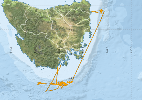
Voyage extents: 44° 33.9' S to 41° 09.3' S 146° 05.1' E to 148° 52.6' E
Marlin Metadata:-
Participants - on ship:-
| Name | Role | Organisation |
|---|---|---|
| Alan Poole | (Former) CSIRO Division of Fisheries/Fisheries Research - Hobart | |
| Alan Williams | (Former) CSIRO Division of Fisheries/Fisheries Research - Hobart | |
| Alex Terauds | (Former) CSIRO Division of Fisheries/Fisheries Research - Hobart | |
| Kath Whitefield-Masson | (Former) CSIRO Division of Fisheries/Fisheries Research - Hobart | |
| Lindsay MacDonald | (Former) CSIRO Division of Fisheries/Fisheries Research - Hobart | |
| Mark Lewis | (Former) CSIRO Division of Fisheries/Fisheries Research - Hobart | |
| Rudy Kloser | Assitant cruise leader | (Former) CSIRO Division of Fisheries/Fisheries Research - Hobart |
| Tim Ryan | (Former) CSIRO Division of Fisheries/Fisheries Research - Hobart | |
| Tony Koslow | Cruise leader | (Former) CSIRO Division of Fisheries/Fisheries Research - Hobart |
This list includes those that may have only been on part of the voyage. See voyage reports on 'Reports and Maps' tab for details.
Marine National Facility Reports - plans, summaries and data processing
-
SS199604 Voyage Plan
- includes objectives, investigator details, proposed data collection, voyage track and equipment to be used.
-

Search for publications, reports and datasets from this and other voyages
Data publishing - No datasets have been published
Deployments by start time:- Click on column header to sort. Use link on 'Deployment' to see full details. Use the CSV button at the bottom to export data (tab delimited).
Search for deployments from this voyage and others
| Deployment | Operation | Station | Cast | Gear | Project | Start and end times | Start Location | End Location | Depth range | Max Depth | Description | |||
|---|---|---|---|---|---|---|---|---|---|---|---|---|---|---|
| CTD Cast [details] | 1 | Cast | 1996-07-18 06:14 | -41.2767 | 148.7600 | |||||||||
| CTD Cast [details] | 2 | Cast | 1996-07-18 06:15 | 1996-07-18 07:12 | -41.2783 | 148.7583 | -41.3033 | 148.7633 | ||||||
| Catch [details] | 3 | Mid Ocean Open Close - MIDOC. | 1996-07-18 09:20 | 1996-07-18 11:30 | -41.1667 | 148.7533 | -41.2867 | 148.7583 | ||||||
| Catch [details] | 4 | 1996-07-19 00:19 | -41.1667 | 148.7517 | ||||||||||
| Catch [details] | 6 | Engel midwater | 1996-07-19 14:10 | 1996-07-19 14:56 | -41.2133 | 148.7217 | -41.2517 | 148.7683 | ||||||
| CTD Cast [details] | 7 | Cast | 1996-07-21 20:45 | -41.2350 | 148.8617 | |||||||||
| CTD Cast [details] | 8 | Cast | 1996-07-21 21:45 | 1996-07-21 22:57 | -41.2350 | 148.8683 | -41.2783 | 148.8617 | ||||||
| CTD Cast [details] | 9 | Cast | 1996-07-25 00:43 | -44.2533 | 146.0917 | |||||||||
| Catch [details] | 10 | Mid Ocean Open Close - MIDOC. | 1996-07-25 09:53 | -44.1833 | 147.1250 | |||||||||
| Catch [details] | 11 | Mid Ocean Open Close - MIDOC. | 1996-07-25 14:03 | 1996-07-25 14:03 | -44.2583 | 147.3167 | ||||||||
| Catch [details] | 12 | 1996-07-25 23:28 | -44.2200 | 147.1333 | ||||||||||
| Catch [details] | 5 | |||||||||||||
| Underway System [details] | Doppler speed log,Licor-UWQ 3708,RM Young 05103 wind monitor,RM Young 05103 wind monitor,Simrad EK500 echosounder,Sperry gyrocompass,Temperature sensor-41342,ThermoSalinoGraph (TSG)-SS-SN 1777,ThermoSalinoGraph (TSG)-SS-SN 1777 | |||||||||||||