Survey details and related metadata, reports, events and data.
West Australian Basin Moorings (1995) (alternative identifier: M-WAB95)
Period: 1995-06-21 00:00 to 1996-07-04 00:00 Local
Duration: 379.00 days
Mooring: West Australian Basin Moorings (1995) [details]
Description: Moored current meters were deployed in the deep-water passage between Cape Mentelle (W Australia) and Broken Plateu in the SE Indian Ocean to measure the flow of deep and bottom water into the West Australian Basin. The moorings were operational between June/July 1995 and July 1996 and were deployed during Franklin voyage FR 06/95, in water depths between 3175 m and 4800 m.
Leader: T. McDougall (CSIRO)
Project: Potential Impact on Climate Change in Relation to Coastal Upwelling 1995-1999 [details]
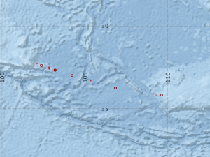
Map extents: 50° 00.0' S to 0° 00.0' N 95° 00.0' E to 180° 00.0' E
Marlin Metadata:-
Participants:- no records
Marine National Facility Reports - plans, summaries and data processing
- There is no map for this survey.
Search for publications, reports and datasets from this and other voyages
Data publishing
This is a list of online datasets hosted by CSIRO. Other processed datasets hosted by collaborating organisations may be found on the 'Metadata' or "Reports, Publications and Maps' tab.
Use the Get data link on the right to extract data using the NCMI Data Trawler.
| Data Stream | Data Summary | Get data | ||||||||||||||
|---|---|---|---|---|---|---|---|---|---|---|---|---|---|---|---|---|
| Current Meter records from Moorings |
|
Get Data from Trawler Processing report for this dataset |
Deployments by start time:- Click on column header to sort. Use link on 'Deployment' to see full details. Use the CSV button at the bottom to export data (tab delimited).
Search for deployments from this voyage and others
| Deployment | Operation | Station | Cast | Gear | Project | Start and end times | Start Location | End Location | Depth range | Max Depth | Description | |||
|---|---|---|---|---|---|---|---|---|---|---|---|---|---|---|
| Current Meter [details] | 1 | 1319 | 1995-06-21 00:00 | 1996-08-09 00:00 | -34.1650 | 109.2883 | 0 | 542 | ||||||
| Current Meter [details] | 1 | 1319 | 1995-06-21 00:00 | 1996-02-01 00:00 | -34.1650 | 109.2883 | 0 | 543 | ||||||
| Current Meter [details] | 1 | 1319 | 1995-06-21 00:00 | 1995-12-08 00:00 | -34.1650 | 109.2883 | 0 | 544 | ||||||
| Current Meter [details] | 1 | 1319 | 1995-06-21 00:00 | 1996-02-29 00:00 | -34.1683 | 109.6250 | 0 | 545 | ||||||
| Current Meter [details] | 1 | 1319 | 1995-06-21 00:00 | 1996-02-28 00:00 | -34.1683 | 109.6250 | 0 | 546 | ||||||
| Current Meter [details] | 1 | 1319 | 1995-06-24 00:00 | 1996-05-27 00:00 | -33.7683 | 106.8500 | 0 | 539 | ||||||
| Current Meter [details] | 1 | 1319 | 1995-06-24 00:00 | 1995-11-20 00:00 | -33.7683 | 106.8500 | 0 | 541 | ||||||
| Current Meter [details] | 1 | 1319 | 1995-06-24 00:00 | 1996-08-24 00:00 | -33.7683 | 106.8500 | 0 | 540 | ||||||
| Current Meter [details] | 1 | 1319 | 1995-06-26 00:00 | 1996-03-26 00:00 | -33.3433 | 105.3767 | 0 | 535 | ||||||
| Current Meter [details] | 1 | 1319 | 1995-06-26 00:00 | 1996-02-19 00:00 | -33.3433 | 105.3767 | 0 | 537 | ||||||
| Current Meter [details] | 1 | 1319 | 1995-06-26 00:00 | 1996-03-18 00:00 | -33.3433 | 105.3767 | 0 | 536 | ||||||
| Current Meter [details] | 1 | 1319 | 1995-06-26 00:00 | 1996-03-10 00:00 | -33.3433 | 105.3767 | 0 | 538 | ||||||
| Current Meter [details] | 1 | 1319 | 1995-07-01 00:00 | 1996-08-27 00:00 | -33.0033 | 104.2433 | 0 | 532 | ||||||
| Current Meter [details] | 1 | 1319 | 1995-07-01 00:00 | 1996-02-01 00:00 | -33.0033 | 104.2433 | 0 | 534 | ||||||
| Current Meter [details] | 1 | 1319 | 1995-07-01 00:00 | 1996-06-15 00:00 | -33.0033 | 104.2433 | 0 | 533 | ||||||
| Current Meter [details] | 1 | 1319 | 1995-07-02 00:00 | 1996-03-02 00:00 | -32.5467 | 102.8233 | 0 | 525 | ||||||
| Current Meter [details] | 1 | 1319 | 1995-07-02 00:00 | 1996-04-19 00:00 | -32.5467 | 102.8233 | 0 | 526 | ||||||
| Current Meter [details] | 1 | 1319 | 1995-07-02 00:00 | 1996-03-01 00:00 | -32.5467 | 102.8233 | 0 | 527 | ||||||
| Current Meter [details] | 1 | 1319 | 1995-07-02 00:00 | 1996-03-17 00:00 | -32.6733 | 103.1950 | 0 | 528 | ||||||
| Current Meter [details] | 1 | 1319 | 1995-07-02 00:00 | 1996-04-06 00:00 | -32.6733 | 103.1950 | 0 | 529 | ||||||
| Current Meter [details] | 1 | 1319 | 1995-07-02 00:00 | 1996-02-20 00:00 | -32.6733 | 103.1950 | 0 | 531 | ||||||
| Current Meter [details] | 1 | 1319 | 1995-07-02 00:00 | 1996-02-20 00:00 | -32.6733 | 103.1950 | 0 | 530 | ||||||
| Current Meter [details] | 1 | 1319 | 1995-07-03 00:00 | 1996-03-19 00:00 | -32.3567 | 102.1233 | 0 | 522 | ||||||
| Current Meter [details] | 1 | 1319 | 1995-07-03 00:00 | 1996-02-15 00:00 | -32.3950 | 102.3717 | 0 | 523 | ||||||
| Current Meter [details] | 1 | 1319 | 1995-07-03 00:00 | 1996-07-04 00:00 | -32.3950 | 102.3717 | 0 | 524 | ||||||