Survey details and related metadata, reports, events and data.
SEF-Gabo Reef Moorings (1996) (alternative identifier: M-SEF96)
Period: 1996-12-02 00:00 to 1996-12-12 00:00 Local
Duration: 10.00 days
Mooring: SEF-Gabo Reef Moorings (1996) [details]
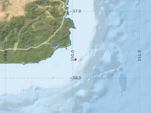
Description: As part of the 1993-6 South-East Fishery (SEF) study, 2 moorings were deployed for a period of 10 days on and off Gabo Reef, off the E Victoria/SE New South Wales Coast, during December 1996, in water depths of 114 and 130 m.
Leader: N. Bax & A. Williams (CSIRO)
Project: Habitat and fisheries production in the south east fishery ecosystem (FRDC project no. 94/040) 1994-1997 [details]
Map extents: 50° 00.0' S to 0° 00.0' N 95° 00.0' E to 180° 00.0' E
Metadata - No Marlin metadata records found or has not been linked to this survey or potentially the metadata catalogue is offline.
Participants:- no records
Marine National Facility Reports - plans, summaries and data processing
- There is no map for this survey.
Search for publications, reports and datasets from this and other voyages
Data publishing
This is a list of online datasets hosted by CSIRO. Other processed datasets hosted by collaborating organisations may be found on the 'Metadata' or "Reports, Publications and Maps' tab.
Use the Get data link on the right to extract data using the NCMI Data Trawler.
| Data Stream | Data Summary | Get data | ||||||||||||||
|---|---|---|---|---|---|---|---|---|---|---|---|---|---|---|---|---|
| Current Meter records from Moorings |
|
Get Data from Trawler |
Deployments by start time:- Click on column header to sort. Use link on 'Deployment' to see full details. Use the CSV button at the bottom to export data (tab delimited).
Search for deployments from this voyage and others
| Deployment | Operation | Station | Cast | Gear | Project | Start and end times | Start Location | End Location | Depth range | Max Depth | Description | |||
|---|---|---|---|---|---|---|---|---|---|---|---|---|---|---|
| Current Meter [details] | 1 | 204 | 1996-12-02 00:00 | 1996-12-12 00:00 | -37.7233 | 150.0483 | 0 | 549 | ||||||
| Current Meter [details] | 1 | 204 | 1996-12-02 00:00 | 1996-12-12 00:00 | -37.7233 | 150.0450 | 0 | 547 | ||||||
| Current Meter [details] | 2 | 204 | 1996-12-02 00:00 | 1996-12-12 00:00 | -37.7233 | 150.0483 | 0 | 550 | ||||||
| Current Meter [details] | 2 | 204 | 1996-12-02 00:00 | 1996-12-12 00:00 | -37.7233 | 150.0450 | 0 | 548 | ||||||