Survey details and related metadata, reports, events and data.
LUCIE: alongshore Moorings (1986/7) (alternative identifier: M-LUCIE86-AS)
Period: 1986-09-07 00:00 to 1987-08-20 00:00 Local
Duration: 347.00 days
Mooring: LUCIE: alongshore Moorings (1986-7) [details]
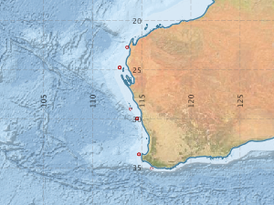
Description: The Alongshore Array forms one of the three main components of the 1986-7 LUCIE (Leeuwin Current Interdisciplinary Experiment) study. It consisted of 6 moorings along the shelf-break from 22.7 deg S to 35.1 deg S, in water depths between 60 and 120 m. The meters were deployed in September 1986 and most were recovered in August 1987.
Leader: J. Church (CSIRO)
Project: Mesoscale and Continental Shelf Oceanography 1981-1989 [details]
Map extents: 50° 00.0' S to 0° 00.0' N 95° 00.0' E to 180° 00.0' E
Marlin Metadata:-
Participants:- no records
Marine National Facility Reports - plans, summaries and data processing
- There is no map for this survey.
Search for publications, reports and datasets from this and other voyages
Data publishing
This is a list of online datasets hosted by CSIRO. Other processed datasets hosted by collaborating organisations may be found on the 'Metadata' or "Reports, Publications and Maps' tab.
Use the Get data link on the right to extract data using the NCMI Data Trawler.
| Data Stream | Data Summary | Get data | ||||||||||||||
|---|---|---|---|---|---|---|---|---|---|---|---|---|---|---|---|---|
| Current Meter records from Moorings |
|
Get Data from Trawler |
Deployments by start time:- Click on column header to sort. Use link on 'Deployment' to see full details. Use the CSV button at the bottom to export data (tab delimited).
Search for deployments from this voyage and others
| Deployment | Operation | Station | Cast | Gear | Project | Start and end times | Start Location | End Location | Depth range | Max Depth | Description | |||
|---|---|---|---|---|---|---|---|---|---|---|---|---|---|---|
| Current Meter [details] | 1 | 1524 | 1986-09-07 00:00 | 1987-07-31 00:00 | -33.6333 | 114.7267 | 0 | 172 | ||||||
| Current Meter [details] | 1 | 1524 | 1986-09-07 00:00 | 1987-04-30 00:00 | -35.0783 | 115.9933 | 0 | 187 | ||||||
| Current Meter [details] | 1 | 1524 | 1986-09-11 00:00 | 1987-02-11 00:00 | -29.9917 | 114.5383 | 0 | 166 | ||||||
| Current Meter [details] | 2 | 1524 | 1986-09-11 00:00 | 1987-02-11 00:00 | -29.9917 | 114.5383 | 0 | 167 | ||||||
| Current Meter [details] | 1 | 1524 | 1986-09-14 00:00 | 1987-06-08 00:00 | -29.0083 | 113.8750 | 0 | 114 | ||||||
| Current Meter [details] | 2 | 1524 | 1986-09-14 00:00 | 1987-06-08 00:00 | -29.0083 | 113.8750 | 0 | 115 | ||||||
| Current Meter [details] | 1 | 1524 | 1986-09-15 00:00 | 1987-08-17 00:00 | -24.7783 | 112.7533 | 0 | 111 | ||||||
| Current Meter [details] | 2 | 1524 | 1986-09-15 00:00 | 1987-08-17 00:00 | -24.7783 | 112.7533 | 0 | 112 | ||||||
| Current Meter [details] | 1 | 1524 | 1986-09-18 00:00 | 1987-08-20 00:00 | -22.7183 | 113.5250 | 0 | 108 | ||||||
| Current Meter [details] | 2 | 1524 | 1986-09-18 00:00 | 1987-08-20 00:00 | -22.7183 | 113.5250 | 0 | 109 | ||||||
| Current Meter [details] | 1 | 1524 | 1986-09-21 00:00 | 1987-08-12 00:00 | -24.7783 | 112.7533 | 0 | 113 | ||||||
| Current Meter [details] | 1 | 1524 | 1986-09-23 00:00 | 1987-08-15 00:00 | -22.7183 | 113.5250 | 0 | 110 | ||||||
| Current Meter [details] | 1 | 1524 | 1987-02-08 00:00 | 1987-08-04 00:00 | -33.6183 | 114.7250 | 0 | 170 | ||||||
| Current Meter [details] | 2 | 1524 | 1987-02-08 00:00 | 1987-08-04 00:00 | -33.6183 | 114.7250 | 0 | 171 | ||||||
| Current Meter [details] | 1 | 1524 | 1987-02-11 00:00 | 1987-08-14 00:00 | -30.0083 | 114.5417 | 0 | 168 | ||||||
| Current Meter [details] | 2 | 1524 | 1987-02-11 00:00 | 1987-08-14 00:00 | -30.0083 | 114.5417 | 0 | 169 | ||||||