Survey details and related metadata, reports, events and data.
Tasman Sea (Lord Howe Rise) Moorings (1989) (alternative identifier: M-LHR89)
Period: 1989-08-24 00:00 to 1990-03-31 00:00 Local
Duration: 219.00 days
Mooring: Tasman Sea (L.H. Rise) Moorings (1989) [details]
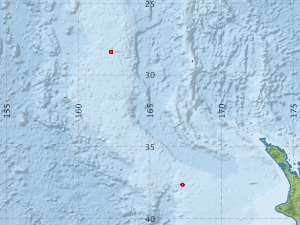
Description: As part of a study of ocean transport in the Tasman Sea, two dynamic height moorings were deployed at different sites (one near 28 deg and one near 38 deg S) on the Lord Howe Rise in the Tasman Sea, in water depths between 1000 and 1500 m, between August 1989 and March 1990. The moorings were deployed during Franklin voyage FR 10/89 and recovered during voyage 03/90.
Leader: J. Church (CSIRO)
Project: Mesoscale and Continental Shelf Oceanography 1981-1989 [details]
Map extents: 50° 00.0' S to 0° 00.0' N 95° 00.0' E to 180° 00.0' E
Marlin Metadata:-
Participants:- no records
Marine National Facility Reports - plans, summaries and data processing
- There is no map for this survey.
Search for publications, reports and datasets from this and other voyages
Data publishing
This is a list of online datasets hosted by CSIRO. Other processed datasets hosted by collaborating organisations may be found on the 'Metadata' or "Reports, Publications and Maps' tab.
Use the Get data link on the right to extract data using the NCMI Data Trawler.
| Data Stream | Data Summary | Get data | ||||||||||||||
|---|---|---|---|---|---|---|---|---|---|---|---|---|---|---|---|---|
| Current Meter records from Moorings |
|
Get Data from Trawler Download to the documentation (pdf) Download the datasets (zipped csv 677kb) |
Deployments by start time:- Click on column header to sort. Use link on 'Deployment' to see full details. Use the CSV button at the bottom to export data (tab delimited).
Search for deployments from this voyage and others
| Deployment | Operation | Station | Cast | Gear | Project | Start and end times | Start Location | End Location | Depth range | Max Depth | Description | |||
|---|---|---|---|---|---|---|---|---|---|---|---|---|---|---|
| Current Meter [details] | 1 | 1524 | 1989-08-24 00:00 | 1990-03-31 00:00 | -37.6733 | 167.2667 | 0 | 248 | ||||||
| Current Meter [details] | 1 | 1524 | 1989-08-24 00:00 | 1990-03-31 00:00 | -37.6733 | 167.2667 | 0 | 252 | ||||||
| Current Meter [details] | 1 | 1524 | 1989-08-24 00:00 | 1990-03-14 00:00 | -37.6733 | 167.2667 | 0 | 256 | ||||||
| Current Meter [details] | 1 | 1524 | 1989-08-24 00:00 | 1990-03-31 00:00 | -37.6733 | 167.2667 | 0 | 254 | ||||||
| Current Meter [details] | 1 | 1524 | 1989-08-24 00:00 | 1990-03-31 00:00 | -37.6733 | 167.2667 | 0 | 250 | ||||||
| Current Meter [details] | 2 | 1524 | 1989-08-24 00:00 | 1990-03-31 00:00 | -37.6733 | 167.2667 | 0 | 253 | ||||||
| Current Meter [details] | 2 | 1524 | 1989-08-24 00:00 | 1990-03-14 00:00 | -37.6733 | 167.2667 | 0 | 257 | ||||||
| Current Meter [details] | 2 | 1524 | 1989-08-24 00:00 | 1990-03-31 00:00 | -37.6733 | 167.2667 | 0 | 251 | ||||||
| Current Meter [details] | 2 | 1524 | 1989-08-24 00:00 | 1990-03-31 00:00 | -37.6733 | 167.2667 | 0 | 255 | ||||||
| Current Meter [details] | 2 | 1524 | 1989-08-24 00:00 | 1990-03-31 00:00 | -37.6733 | 167.2667 | 0 | 249 | ||||||
| Current Meter [details] | 1 | 1524 | 1989-08-31 00:00 | 1990-03-28 00:00 | -28.3867 | 162.2883 | 0 | 236 | ||||||
| Current Meter [details] | 1 | 1524 | 1989-08-31 00:00 | 1990-03-23 00:00 | -28.3867 | 162.2883 | 0 | 246 | ||||||
| Current Meter [details] | 1 | 1524 | 1989-08-31 00:00 | 1990-03-28 00:00 | -28.3867 | 162.2883 | 0 | 244 | ||||||
| Current Meter [details] | 1 | 1524 | 1989-08-31 00:00 | 1990-03-28 00:00 | -28.3867 | 162.2883 | 0 | 242 | ||||||
| Current Meter [details] | 1 | 1524 | 1989-08-31 00:00 | 1990-03-04 00:00 | -28.3867 | 162.2883 | 0 | 240 | ||||||
| Current Meter [details] | 1 | 1524 | 1989-08-31 00:00 | 1990-03-28 00:00 | -28.3867 | 162.2883 | 0 | 238 | ||||||
| Current Meter [details] | 2 | 1524 | 1989-08-31 00:00 | 1990-03-04 00:00 | -28.3867 | 162.2883 | 0 | 241 | ||||||
| Current Meter [details] | 2 | 1524 | 1989-08-31 00:00 | 1990-03-28 00:00 | -28.3867 | 162.2883 | 0 | 243 | ||||||
| Current Meter [details] | 2 | 1524 | 1989-08-31 00:00 | 1990-03-28 00:00 | -28.3867 | 162.2883 | 0 | 239 | ||||||
| Current Meter [details] | 2 | 1524 | 1989-08-31 00:00 | 1990-03-28 00:00 | -28.3867 | 162.2883 | 0 | 245 | ||||||
| Current Meter [details] | 2 | 1524 | 1989-08-31 00:00 | 1990-03-28 00:00 | -28.3867 | 162.2883 | 0 | 237 | ||||||
| Current Meter [details] | 2 | 1524 | 1989-08-31 00:00 | 1990-03-23 00:00 | -28.3867 | 162.2883 | 0 | 247 | ||||||