Survey details and related metadata, reports, events and data.
LI2014_V14
Period: 2014-07-10 01:00 to 2014-07-10 07:36 UTC
Duration: 0.28 days
From: Hillarys Boat Harbour To: Hillarys Boat Harbour
Ship: Linnaeus (RV) [details]
Description: The purpose of this voyage was to service IMOS moorings due East of Two Rocks
Project: Linnaeus Underway [details]
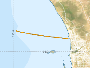
Voyage extents: 31° 50.0' S to 31° 43.1' S 115° 02.2' E to 115° 44.3' E Get voyage track shapefile Get CSV
Marlin Metadata:-
Participants:- no records
Marine National Facility Reports - plans, summaries and data processing
- View Survey map
Search for publications, reports and datasets from this and other voyages
Data publishing
This is a list of online datasets hosted by CSIRO. Other processed datasets hosted by collaborating organisations may be found on the 'Metadata' or "Reports, Publications and Maps' tab.
Use the Get data link on the right to extract data using the NCMI Data Trawler.
| Data Stream | Data Summary | Get data | ||||||||||||
|---|---|---|---|---|---|---|---|---|---|---|---|---|---|---|
| Underway |
|
Get Data from Trawler Download 10 second csv format: li2014_v14uwy10_csv.zip Download 5 minute csv format: li2014_v14uwy5min_csv.zip Download 1 second NetCDF format: li2014_v14uwy_nc.zip Download the processing report: li2014_v14_UwyDataProcessing.pdf |
Deployments by start time:- Click on column header to sort. Use link on 'Deployment' to see full details. Use the CSV button at the bottom to export data (tab delimited).
Search for deployments from this voyage and others
| Deployment | Operation | Station | Cast | Gear | Project | Start and end times | Start Location | End Location | Depth range | Max Depth | Description | |||
|---|---|---|---|---|---|---|---|---|---|---|---|---|---|---|
| Underway System [details] | GPS - Garmin,GPS - Garmin,Remote Temperature (T) - SN 618 | 2419 | 2014-07-10 01:00 | 2014-07-10 07:37 | -31.8263 | 115.7375 | -31.8239 | 115.7373 | ||||||