Data Trawler - Survey Details

Please login if you have access to particular applications.
Username:
Password:

Voyage details and related metadata, reports, events and data.

IN2017_E04    - is a Marine National Facility voyage

Title: Sea Trials, Calibration & Training

Voyage details on MNF site: https://mnf.csiro.au/en/Voyages/IN2017_E04

Period: 2017-12-06 21:00 to 2017-12-11 15:30 UTC

Duration: 4.77 days

From: Hobart To: Hobart

Region: South east Tasmanian waters

Ship: Investigator (RV) [details]

Description: RV Investigator research voyage in2017_e04, titled “Sea Trials, Calibration & Training.” This trial voyage will start and finish in Hobart and will conduct tests and calibration of MNF equipment plus training for MNF staff and future scientific voyage participants.

Leader: Mark Scanlon

Project: none linked to this survey.


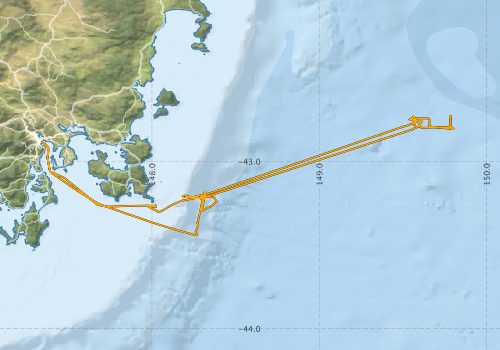
Voyage extents: 43° 26.6' S to 42° 43.6' S    147° 20.3' E to 149° 48.5' E Get voyage track shapefile Get CSV


Marlin Metadata:-

  • RV Investigator Radon Data - Selected Voyages (2014 onwards) [details]

  • RV Investigator Underway UWY Data (Unprocessed) [details]

  • RV Investigator Voyage IN2017_E04 EK60 Echosounder [details]

  • RV Investigator Voyage IN2017_E04 EM122 Multibeam Echosounder Data [details]

  • RV Investigator Voyage IN2017_E04 EM710 MKII Multibeam Echosounder Data [details]

  • RV Investigator Voyage IN2017_E04 End of Voyage (EOV) Archive [details]

  • RV Investigator Voyage IN2017_E04 Gravity Data [details]

  • RV Investigator Voyage IN2017_E04 SBP120 Sub-bottom Profiler Data [details]

  • RV Investigator Voyage IN2017_E04 Underway UWY Data (Unprocessed) [details]

  • RV Investigator Voyage IN2017_E04 XBT Data [details]

  • Cruise Summary Report at SeaDataNet:-

  • View Cruise Summary Report at https://csr.seadatanet.org
  • Participants - on ship:-

    NameRoleOrganisation Project
    Mark Scanlon Voyage Manager Marine National Facility Voyage Management on RV Investigator
    Paul Livingston Acting Ship Manager ASP Ship Management Group Voyage Management on RV Investigator
    Zoe Burton Deputy Voyage Manager Marine National Facility Voyage Management on RV Investigator

    This list includes those that may have only been on part of the voyage. See voyage reports on 'Reports and Maps' tab for details.

    Marine National Facility Reports - plans, summaries and data processing

    Search for publications, reports and datasets from this and other voyages

    Data publishing

    This is a list of online datasets hosted by CSIRO. Other processed datasets hosted by collaborating organisations may be found on the 'Metadata' or "Reports, Publications and Maps' tab.
    Use the Get data link on the right to extract data using the NCMI Data Trawler.

    Data StreamData SummaryGet data
    Gravity Measurements
    Time (UTC): 2017-12-06 21:12 to 2017-12-11 20:12
    Latitude: -43.44 to -42.73
    Longitude: 147.34 to 149.81
    Get Data from Trawler

    Geophysical Survey and Mapping acquisition report

    Multibeam echosounder
    Time (UTC): 2017-12-06 23:12 to 2017-12-10 20:12
    Latitude: -43.44 to -42.74
    Longitude: 147.36 to 149.80
    Datafiles: 68
    Total size: 4.80 Gb
    Get Data from Trawler

    Radon measurements
    Time (UTC): 2017-12-07 00:00 to 2017-12-10 18:00
    Latitude: -43.43 to -42.73
    Longitude: 147.36 to 149.81
    Measurements:91
    Get Data from Trawler

    Download RV Investigator Radon dataset (XLSX)

    Sub-bottom profiler
    Time (UTC): 2017-12-07 23:31 to 2017-12-11 20:47
    Latitude: -43.38 to -42.75
    Longitude: 147.36 to 149.78
    Datafiles: 19
    Total size: 1.89 Gb
    Get Data from Trawler

    Geophysical Survey and Mapping data acquisition and processing report

    Singlebeam echosounder
    Time (UTC): 2017-12-07 03:50 to 2017-12-10 19:38
    Latitude: -43.44 to -42.73
    Longitude: 147.36 to 149.81
    Datafiles: 94
    Total size: 7.96 Gb
    Get Data from Trawler

    Geophysical Survey and Mapping acquisition report

    XBT Profile
    Time (UTC): 2017-12-09 19:12 to 2017-12-09 19:12
    Latitude: -43.20
    Longitude: 148.31
    Quantity: 1 Casts
    Max Pressure: 1100.3 db
    Get Data from Trawler

    Geophysical Survey and Mapping data acquisition and processing report

    Caveat: this event log was authored on the voyage using either a standalone logging system called ELOG or more recently an inhouse event logging tool called Everlog. For this reason, some positions are unknown and may be resolved using the logged time and the underway dataset for the voyage.

    Search for events from this voyage and others

    Events ordered by start time:- Click on column header to sort. Use link on 'When' to see full details. Use the CSV button at the bottom to export data.

    When (UTC) LatitudeLongitude InstrumentIdentifierActionLogSubject / Comments
    2017-12-07 04:58 [view ] -43.0728 147.4167 EM710 [view] Crash GSM_in2017_e04 SIS crash
    2017-12-07 06:35 [view ] -43.2690 147.7240 EM710 [view] SVP GSM_in2017_e04 updated svp to in2017_e04_sst03.asvp
    2017-12-07 06:51 [view ] -43.2687 147.7897 EM710 [view] SVP GSM_in2017_e04 back to in2017_e04_sst002.asvp
    2017-12-07 07:21 [view ] -43.2650 147.9142 EM710 [view] SVP GSM_in2017_e04 New SVP applied in2017_e04_sst003.asvp SST= 16.5C
    2017-12-07 07:25 [view ] -43.2650 147.9300 ADCP [view] Stop in2017_e04 stopped while GSM do some calibrations
    2017-12-07 07:28 [view ] -43.2648 147.9423 EM710 [view] Other GSM_in2017_e04 Offset values zeroed in SIS
    2017-12-07 07:43 [view ] -43.2657 148.0015 EM710 [view] Start GSM_in2017_e04 Start patch test roll/pitch line 1 Heading 090 SIS angular offsets zeroed Pitch stabilisation on Yaw stabilisation on Dual swath off Beam spacing HD Equidistant Beam angles 68/68 ACDP, EK60 off Internal trigger
    2017-12-07 07:56 [view ] -43.2653 148.0170 EM710 [view] Start GSM_in2017_e04 Start partch test roll/pitch line 2 Heading 270
    2017-12-07 08:14 [view ] -43.2687 147.9973 EM710 [view] Start GSM_in2017_e04 Patch test yaw line HDG 090
    2017-12-07 08:56 [view ] -43.2822 148.0007 EM710 [view] Other GSM_in2017_e04 Patch test values reapplied in SIS- former values verified Roll= -0.17 Pitch = 0.02 Yaw= -0.03
    2017-12-07 09:04 [view ] -43.2947 148.0253 EM710 [view] Stop GSM_in2017_e04 Stop pinging/logging
    2017-12-07 09:07 [view ] -43.2975 148.0295 ADCP [view] in2017_e04 ADCPs started
    2017-12-07 18:56 [view ] -42.7635 149.6080 ADCP [view] in2017_e04 Bottom Tracking off Turned bottom tracking off for both OS150 and OS75
    2017-12-07 22:38 [view ] -42.7623 149.6053 Wind Profiler Start in2017_e04
    2017-12-07 22:52 [view ] -42.7623 149.6050 Gravity Meter [view] Start GSM_in2017_e04 Start logging
    2017-12-07 23:41 [view ] -42.7622 149.6048 EM122 [view] SVP GSM_in2017_e04 in2017_304_ctd004bin_10dbar.asvp
    2017-12-07 23:55 [view ] -42.7782 149.5968 Underway Kendal Hydrochem Lab : TSG01 Sample TSG_Samples_in2017_e04
    2017-12-07 23:58 [view ] -42.7845 149.5960 Underway Kendal Hydrochem Lab : TSG02 Sample TSG_Samples_in2017_e04
    2017-12-08 00:00 [view ] -42.7890 149.5975 Underway Kendal Hydrochem Lab : TSG03 Sample TSG_Samples_in2017_e04
    2017-12-08 01:00 [view ] -42.7898 149.7855 EM122 [view] Other GSM_in2017_e04 Offsets values zeroed in SIS for EM122 patch test
    2017-12-08 01:02 [view ] -42.7850 149.7855 EM122 [view] Start GSM_in2017_e04 Start EM122 roll patch test line 1 HDG 000 SIS values zeroed Pitch stablilization on Yaw stabilization on Dual swath mode off Max angles 70/70 Beam spacing In between Ping mode DEEP
    2017-12-08 01:33 [view ] -42.7392 149.7847 EM122 [view] Start GSM_in2017_e04 Start roll patch test line 2 HDG 180
    2017-12-08 08:15 [view ] -42.7732 149.6593 EM122 [view] Start GSM_in2017_e04 Start EM122 yaw calibration line Heading 000
    2017-12-08 08:53 [view ] -42.7493 149.5697 EM122 [view] Start GSM_in2017_e04 Start EM122 pitch calibration line 1 HDG 180
    2017-12-08 09:17 [view ] -42.7783 149.5700 EM122 [view] Start GSM_in2017_e04 Start EM122 pitch/yaw calibration line 2 HDG 000
    2017-12-08 09:47 [view ] -42.7337 149.5677 EM122 [view] Other GSM_in2017_e04 Calibration values reapplied in SIS- previous values confirmed Roll= -0.14 Pitch= -0.03 Yaw= 0.1
    2017-12-09 19:00 [view ] -43.2079 148.2876 XBT [view] Drop GSM_in2017_e04 XBT drop 1 prior to EM710 1000m calibration 43 12.4750
    2017-12-09 19:25 [view ] -43.2127 148.2797 EM710 [view] SVP GSM_in2017_e04 Applied in2017_e04_xbt_001
    2017-12-09 19:36 [view ] -43.2047 148.3043 EM710 [view] Line GSM_in2017_e04 Start E-W EM710 deep water cal line 1
    2017-12-09 19:39 [view ] -43.2055 148.2968 EM710 [view] Line GSM_in2017_e04 reset angular offest to zero
    2017-12-09 19:49 [view ] -43.2089 148.2903 ADCP [view] Stop in2017_e04 ADCP Stopped for GSM calibration OS75 ADCP Stopped for GSM calibration
    2017-12-09 19:53 [view ] -43.2080 148.3032 EM710 [view] Line GSM_in2017_e04 restart deep water cal Had to redo the e-w line as em710 stopped finding bottom.
    2017-12-09 19:58 [view ] -43.2048 148.3038 EM710 [view] Line GSM_in2017_e04 Start of e-W line 1 - em710 deep cal yaw
    2017-12-09 20:09 [view ] -43.2052 148.2747 EM710 [view] Line GSM_in2017_e04 EOL 1 (E-W) EM710 deep water calibration yaw
    2017-12-09 20:23 [view ] -43.2182 148.2795 EM710 [view] Line GSM_in2017_e04 SOL 2 W-E EM710 Deep Cal pitch
    2017-12-09 20:29 [view ] -43.2190 148.3053 EM710 [view] Line GSM_in2017_e04 EOL 2 W-E EM710 Deep Cal pitch
    2017-12-09 21:16 [view ] -43.2180 148.2970 EM710 [view] Line GSM_in2017_e04 SOL 3 E-W EM710 Deep cal yaw/pitch
    2017-12-09 21:24 [view ] -43.2180 148.2753 EM710 [view] Line GSM_in2017_e04 EOL 3 E-W EM710 Deep cal yaw/pitch
    2017-12-09 21:39 [view ] -43.2117 148.2217 EM710 [view] Line GSM_in2017_e04 SOL 4 EM710 Deep Cal (E-W) Roll
    2017-12-09 21:47 [view ] -43.2115 148.1990 EM710 [view] Line GSM_in2017_e04 EOL 4 E- W EM710 deep cal Roll
    2017-12-09 22:23 [view ] -43.2117 148.2012 EM710 [view] Line GSM_in2017_e04 SOL 5 W-E EM710 Deep cal Roll
    2017-12-09 22:30 [view ] -43.2117 148.2245 EM710 [view] Line GSM_in2017_e04 EOL 5 W-E EM710 deep cal roll
    2017-12-09 22:41 [view ] -43.2118 148.2692 EM710 [view] Other GSM_in2017_e04 angular offset values re entered
    2017-12-09 22:45 [view ] -43.2120 148.2848 EM710 [view] Stop GSM_in2017_e04 Stop pinging
    2017-12-09 22:45 [view ] -43.2120 148.2868 EM122 [view] Start GSM_in2017_e04 Start pinging Use SVP profile XBT001
    2017-12-10 03:34 [view ] -43.2642 148.3582 SBP [view] Start GSM_in2017_e04 start logging SBP
    2017-12-10 03:53 [view ] -43.2745 148.3402 EM122 [view] Stop GSM_in2017_e04 Stopped logging Logging in the wrong survey in2017_e03
    2017-12-10 03:56 [view ] -43.2757 148.3363 EM122 [view] Start GSM_in2017_e04 Start logging on new survey in2017_e04
    2017-12-10 08:05 [view ] -43.3887 148.2733 ADCP [view] Start in2017_e04 restarted

    Save this list as

    Deployments by start time:- Click on column header to sort. Use link on 'Deployment' to see full details. Use the CSV button at the bottom to export data (tab delimited).

    Search for deployments from this voyage and others

    Deployment OperationStationCastGearProject Start and end timesStart LocationEnd LocationDepthDescription
    XBT Cast [details]   Sippican Deep Blue 2548 2017-12-10 06:00 1100.3

    Save this list as

    NCMI Information and Data Centre  »  Applications  »  Data Trawler