Voyage details and related metadata, reports, events and data.
FR 02/2001
(alternative identifier: FR200102)
- is a Marine National Facility ![]() voyage
voyage
Period: 2001-02-15 00:00 to 2001-03-05 00:00 Local
Duration: 18.00 days
From: Adelaide To: Hobart
Region: South Australia Coast off Adelaide
Ship: Franklin [details]
Description:
During research voyage FR02/2001 R/V Franklin will use its SeaSoar in a study of small scale mixing processes in the Subtropical Front south of Australia.
There are four principal objectives:
1.To determine the relationship between thermohaline structures and density compensation in the Subtropical Front.
2.To determine the influence of density compensation on vertical mixing.
3.To determine the influence of changing surface wind stress on horizontal advection and vertical mixing.
4.To determine the temporal scales of interleaving events in the Subtropical Front.
Leader: M Tomczak (Flinders University)
Project: National Facility External Users: M. Tomczak (Flinders University) [details]
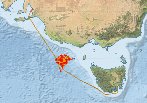
Voyage extents: 43° 47.9' S to 34° 46.6' S 138° 01.9' E to 147° 29.9' E Get voyage track shapefile Get CSV
Marlin Metadata:-
Metadata from OBIS Australia datasets:- biological data is published via the OBIS-AU IPT server and delivered to one or more of OBIS, ALA and GBIF
Download from OBIS Australia IPT View at - Ocean Biodiversity Information System (OBIS) Atlas of Living Australia (ALA) GBIF
Participants - on ship:-
| Name | Role | Organisation |
|---|---|---|
| Aneurin Henry-James | Flinders University | |
| Charles James | Flinders University | |
| Gary Critchley | Hydrochemistry | CSIRO Marine Research |
| Kevin Miller | Moorings | CSIRO Marine and Atmospheric Research |
| Lindsay Pender | Cruise Manager | CSIRO Marine Research |
| Matthias Tomczak | Chief Investigator | Flinders University |
| Phil Adams | Electronics | CSIRO Marine Research |
| Roger Matthews | Flinders University |
This list includes those that may have only been on part of the voyage. See voyage reports on 'Reports and Maps' tab for details.
Marine National Facility Reports - plans, summaries and data processing
-
FR200102 Voyage Summary
- includes preliminary results, voyage narrative, types of data collected with C77/ROSCOP codes.
-

Publications, reports and datasets from this voyage.
IPT Resource
- Seabird observations in Australian and adjacent seas from voyages of the RV Franklin, RV Southern Surveyor, Southern Supporter and RV Aurora Australis (1988-2012) (Darwin Core Archive) External link to reference
Search for publications, reports and datasets from this and other voyages
Data publishing
This is a list of online datasets hosted by CSIRO. Other processed datasets hosted by collaborating organisations may be found on the 'Metadata' or "Reports, Publications and Maps' tab.
Use the Get data link on the right to extract data using the NCMI Data Trawler.
| Data Stream | Data Summary | Get data | ||||||||||||||
|---|---|---|---|---|---|---|---|---|---|---|---|---|---|---|---|---|
| ADCP Data |
|
Get Data from Trawler Download NetCDF dataset fr0102adcpCDF.zip Download dataset 7.4 / 1.6 Mb in 14 files Processing report for this dataset |
||||||||||||||
| Marine biodiversity observations and/or samples |
|
Get Data from Trawler |
||||||||||||||
| CTD profile |
|
Get Data from Trawler |
||||||||||||||
| Hydrology |
|
Get Data from Trawler Processing report for this dataset |
||||||||||||||
| Towed CTD |
|
Get Data from Trawler Download FR200102 Seasoar data |
||||||||||||||
| Underway |
|
Get Data from Trawler |
Deployments by start time:- Click on column header to sort. Use link on 'Deployment' to see full details. Use the CSV button at the bottom to export data (tab delimited).
Search for deployments from this voyage and others
| Deployment | Operation | Station | Cast | Gear | Project | Start and end times | Start Location | End Location | Depth range | Max Depth | Description | |||
|---|---|---|---|---|---|---|---|---|---|---|---|---|---|---|
| Underway System [details] | Anemometer,Anemometer,Anemometer,Barometer,Gyro-MK 10,Humidity probe,Licor-UWQ 4653,RIMCO vane driving potentiometer,RIMCO vane driving potentiometer,Ships log,Simrad EA500 Echosounder,Temperature sensor-AD590J,ThermoSalinoGraph (TSG)-Franklin,ThermoSalinoGraph (TSG)-Franklin | 124 | 2001-02-15 00:00 | 2001-03-05 23:59 | -34.7762 | 138.4820 | -42.9452 | 147.3760 | ||||||
| ADCP Data [details] | RDI VM-150 Acoustic Doppler current profiler | 124 | 2001-02-16 01:00 | 2001-03-05 14:40 | -34.9610 | 138.3050 | -43.6850 | 147.1230 | 376.8 | |||||
| CTD Cast / Hydrology [details] | 1 | Cast 1 | CTD 20 - SN 0552,Conductivity CTD 20-SN 2312,Oxygen CTD 20-Becman 527,Pressure CTD 20-SN 75638,Temperature CTD 20-SN 2466 | 124 | 2001-02-17 13:36 | 2001-02-17 14:33 | -40.0030 | 140.9981 | -40.0053 | 140.9957 | 1502 | |||
| Towed CTD [details] | SeaSoar | 124 | 2001-02-17 15:15 | 2001-02-17 18:28 | -40.0153 | 141.0062 | -40.4458 | 141.1502 | 213 | Leg: 02 | ||||
| Towed CTD [details] | SeaSoar | 124 | 2001-02-17 18:32 | 2001-02-17 23:20 | -40.4543 | 141.1530 | -41.0607 | 141.3545 | 203.7 | Leg: 03 | ||||
| Towed CTD [details] | SeaSoar | 124 | 2001-02-17 23:21 | 2001-02-18 01:37 | -41.0638 | 141.3558 | -41.3403 | 141.4572 | 203 | Leg: 04 | ||||
| CTD Cast / Hydrology [details] | 1 | Cast 2 | CTD 20 - SN 0552,Conductivity CTD 20-SN 2312,Oxygen CTD 20-Becman 527,Pressure CTD 20-SN 75638,Temperature CTD 20-SN 2466 | 124 | 2001-02-18 02:28 | 2001-02-18 03:24 | -41.3335 | 141.4552 | -41.3305 | 141.4516 | 1502 | |||
| Towed CTD [details] | SeaSoar | 124 | 2001-02-18 04:03 | 2001-02-18 08:45 | -41.3285 | 141.4588 | -40.7272 | 141.7940 | 202 | Leg: 06 | ||||
| Towed CTD [details] | SeaSoar | 124 | 2001-02-18 08:50 | 2001-02-18 12:39 | -40.7158 | 141.8000 | -40.2560 | 142.0450 | 203 | Leg: 07 | ||||
| Towed CTD [details] | SeaSoar | 124 | 2001-02-18 12:43 | 2001-02-18 16:32 | -40.2482 | 142.0493 | -39.8158 | 142.2690 | 202 | Leg: 08 | ||||
| Towed CTD [details] | SeaSoar | 124 | 2001-02-18 16:37 | 2001-02-18 20:09 | -39.8160 | 142.2553 | -39.8170 | 141.6767 | 202 | Leg: 09 | ||||
| Towed CTD [details] | SeaSoar | 124 | 2001-02-18 20:13 | 2001-02-18 21:20 | -39.8185 | 141.6650 | -39.9695 | 141.6678 | 202 | Leg: 10 | ||||
| CTD Cast / Hydrology [details] | 1 | Cast 3 | CTD 20 - SN 0552,Conductivity CTD 20-SN 2312,Oxygen CTD 20-Becman 527,Pressure CTD 20-SN 75638,Temperature CTD 20-SN 2466 | 124 | 2001-02-19 02:33 | 2001-02-19 03:32 | -40.5015 | 141.6651 | -40.5032 | 141.6623 | 1502 | |||
| Towed CTD [details] | SeaSoar | 124 | 2001-02-19 05:30 | 2001-02-19 06:10 | -40.4958 | 141.6058 | -40.4967 | 141.5162 | 139 | Leg: 12 | ||||
| Towed CTD [details] | SeaSoar | 124 | 2001-02-19 06:18 | 2001-02-19 10:00 | -40.4968 | 141.4975 | -40.2773 | 141.5692 | 202 | Leg: 13 | ||||
| Towed CTD [details] | SeaSoar | 124 | 2001-02-19 10:06 | 2001-02-19 14:01 | -40.2687 | 141.5800 | -40.6120 | 141.6608 | 202 | Leg: 14 | ||||
| Towed CTD [details] | SeaSoar | 124 | 2001-02-19 14:04 | 2001-02-19 15:04 | -40.6190 | 141.6605 | -40.7453 | 141.6535 | 201 | Leg: 15 | ||||
| Towed CTD [details] | SeaSoar | 124 | 2001-02-19 15:15 | 2001-02-19 18:20 | -40.7680 | 141.6545 | -40.4870 | 142.0238 | 201 | Leg: 16 | ||||
| Towed CTD [details] | SeaSoar | 124 | 2001-02-19 18:28 | 2001-02-19 19:04 | -40.4748 | 142.0387 | -40.4675 | 141.9458 | 202 | Leg: 17 | ||||
| Towed CTD [details] | SeaSoar | 124 | 2001-02-19 19:16 | 2001-02-19 23:02 | -40.4682 | 141.9120 | -40.4510 | 141.2462 | 203 | Leg: 18 | ||||
| CTD Cast / Hydrology [details] | 1 | Cast 4 | CTD 20 - SN 0552,Conductivity CTD 20-SN 2312,Oxygen CTD 20-Becman 527,Pressure CTD 20-SN 75638,Temperature CTD 20-SN 2466 | 124 | 2001-02-20 00:01 | 2001-02-20 00:58 | -40.4533 | 141.2427 | 1502 | |||||
| Towed CTD [details] | SeaSoar | 124 | 2001-02-20 01:14 | 2001-02-20 03:54 | -40.4605 | 141.2443 | -40.7383 | 141.6207 | 201 | Leg: 19 | ||||
| Towed CTD [details] | SeaSoar | 124 | 2001-02-20 03:59 | 2001-02-20 08:28 | -40.7435 | 141.6352 | -40.1413 | 141.6288 | 202 | Leg: 20 | ||||
| Towed CTD [details] | SeaSoar | 124 | 2001-02-20 08:31 | 2001-02-20 11:50 | -40.1342 | 141.6292 | -40.4318 | 142.0225 | 202 | Leg: 21 | ||||
| CTD Cast / Hydrology [details] | 1 | Cast 5 | CTD 20 - SN 0552,Conductivity CTD 20-SN 2312,Oxygen CTD 20-Becman 527,Pressure CTD 20-SN 75638,Temperature CTD 20-SN 2466 | 124 | 2001-02-20 12:22 | 2001-02-20 13:18 | -40.4234 | 142.0094 | -40.4175 | 141.9975 | 1502 | |||
| Towed CTD [details] | SeaSoar | 124 | 2001-02-20 14:23 | 2001-02-20 19:18 | -40.4222 | 141.9032 | -40.4160 | 141.0523 | 202 | Leg: 23 | ||||
| Towed CTD [details] | SeaSoar | 124 | 2001-02-20 19:22 | 2001-02-20 23:50 | -40.4152 | 141.0423 | -39.9925 | 141.6007 | 201 | Leg: 24 | ||||
| Towed CTD [details] | SeaSoar | 124 | 2001-02-20 23:56 | 2001-02-21 06:08 | -39.9872 | 141.6142 | -40.7538 | 141.6107 | 202 | Leg: 25 | ||||
| Towed CTD [details] | SeaSoar | 124 | 2001-02-21 06:12 | 2001-02-21 06:55 | -40.7622 | 141.6112 | -40.8457 | 141.6118 | 202 | Leg: 26 | ||||
| Towed CTD [details] | SeaSoar | 124 | 2001-02-21 07:00 | 2001-02-21 11:42 | -40.8518 | 141.6198 | -40.4290 | 142.1682 | 201 | Leg: 27 | ||||
| Towed CTD [details] | SeaSoar | 124 | 2001-02-21 11:48 | 2001-02-21 17:46 | -40.4212 | 142.1790 | -40.4198 | 141.2068 | 202 | Leg: 28 | ||||
| Towed CTD [details] | SeaSoar | 124 | 2001-02-21 17:50 | 2001-02-21 18:50 | -40.4198 | 141.1965 | -40.4133 | 141.0433 | 231 | Leg: 29 | ||||
| CTD Cast / Hydrology [details] | 1 | Cast 6 | CTD 20 - SN 0552,Conductivity CTD 20-SN 2312,Oxygen CTD 20-Becman 527,Pressure CTD 20-SN 75638,Temperature CTD 20-SN 2466 | 124 | 2001-02-21 20:22 | 2001-02-21 21:21 | -40.4161 | 141.0459 | -40.4059 | 141.0553 | 1502 | |||
| Towed CTD [details] | SeaSoar | 124 | 2001-02-21 21:47 | 2001-02-22 02:38 | -40.3753 | 141.0535 | -40.8387 | 141.5985 | 202 | Leg: 31 | ||||
| Towed CTD [details] | SeaSoar | 124 | 2001-02-22 02:45 | 2001-02-22 07:03 | -40.8463 | 141.6123 | -40.2633 | 141.6243 | 201 | Leg: 32 | ||||
| Towed CTD [details] | SeaSoar | 124 | 2001-02-22 08:31 | 2001-02-22 11:44 | -40.1898 | 141.5440 | -39.7853 | 141.5520 | 201 | Leg: 34 | ||||
| Towed CTD [details] | SeaSoar | 124 | 2001-02-22 11:50 | 2001-02-22 16:42 | -39.7722 | 141.5532 | -40.1728 | 142.1273 | 201 | Leg: 35 | ||||
| Towed CTD [details] | SeaSoar | 124 | 2001-02-22 16:46 | 2001-02-22 21:25 | -40.1745 | 142.1158 | -40.1563 | 141.3445 | 201 | Leg: 36 | ||||
| Towed CTD [details] | SeaSoar | 124 | 2001-02-22 21:29 | 2001-02-22 23:15 | -40.1567 | 141.3295 | -40.1615 | 140.9887 | 201 | Leg: 37 | ||||
| Towed CTD [details] | SeaSoar | 124 | 2001-02-22 23:19 | 2001-02-23 04:28 | -40.1593 | 140.9783 | -39.7093 | 141.5772 | 202 | Leg: 38 | ||||
| CTD Cast / Hydrology [details] | 1 | Cast 7 | CTD 20 - SN 0552,Conductivity CTD 20-SN 2312,Oxygen CTD 20-Becman 527,Pressure CTD 20-SN 75638,Temperature CTD 20-SN 2466 | 124 | 2001-02-23 06:35 | 2001-02-23 07:28 | -39.7272 | 141.5562 | -39.7348 | 141.5607 | 1502 | |||
| Towed CTD [details] | SeaSoar | 124 | 2001-02-23 08:26 | 2001-02-23 14:38 | -39.7413 | 141.5557 | -40.5505 | 141.5408 | 201 | Leg: 40 | ||||
| Towed CTD [details] | SeaSoar | 124 | 2001-02-23 14:45 | 2001-02-23 16:54 | -40.5655 | 141.5410 | -40.3797 | 141.8058 | 201 | Leg: 41 | ||||
| Towed CTD [details] | SeaSoar | 124 | 2001-02-23 17:49 | 2001-02-23 20:41 | -40.4015 | 141.7947 | -40.1455 | 142.0993 | 201 | Leg: 42 | ||||
| Towed CTD [details] | SeaSoar | 124 | 2001-02-23 20:47 | 2001-02-24 01:46 | -40.1363 | 142.0970 | -40.1305 | 141.2345 | 201 | Leg: 43 | ||||
| Towed CTD [details] | SeaSoar | 124 | 2001-02-24 01:50 | 2001-02-24 02:53 | -40.1305 | 141.2235 | -40.1300 | 141.0355 | 201 | Leg: 44 | ||||
| Towed CTD [details] | SeaSoar | 124 | 2001-02-24 02:59 | 2001-02-24 08:33 | -40.1298 | 141.0178 | -40.5993 | 141.5313 | 202 | Leg: 45 | ||||
| CTD Cast / Hydrology [details] | 1 | Cast 8 | CTD 20 - SN 0552,Conductivity CTD 20-SN 2312,Oxygen CTD 20-Becman 527,Pressure CTD 20-SN 75638,Temperature CTD 20-SN 2466 | 124 | 2001-02-24 09:30 | 2001-02-24 10:24 | -40.5627 | 141.4932 | -40.5568 | 141.4923 | 1504 | |||
| Towed CTD [details] | SeaSoar | 124 | 2001-02-24 10:53 | 2001-02-24 15:45 | -40.5428 | 141.4918 | -39.9202 | 141.4783 | 202 | Leg: 47 | ||||
| Towed CTD [details] | SeaSoar | 124 | 2001-02-24 15:51 | 2001-02-24 17:47 | -39.9075 | 141.4782 | -39.6737 | 141.4712 | 202 | Leg: 48 | ||||
| Towed CTD [details] | SeaSoar | 124 | 2001-02-24 17:53 | 2001-02-24 22:12 | -39.6613 | 141.4728 | -40.0812 | 142.0350 | 201 | Leg: 49 | ||||
| CTD Cast / Hydrology [details] | 1 | Cast 9 | CTD 20 - SN 0552,Conductivity CTD 20-SN 2312,Oxygen CTD 20-Becman 527,Pressure CTD 20-SN 75638,Temperature CTD 20-SN 2466 | 124 | 2001-02-24 23:05 | 2001-02-25 00:01 | -40.0882 | 142.0439 | -40.0827 | 142.0546 | 1504 | |||
| Towed CTD [details] | SeaSoar | 124 | 2001-02-25 00:26 | 2001-02-25 05:38 | -40.0848 | 142.0475 | -40.0880 | 141.0940 | 201 | Leg: 51 | ||||
| Towed CTD [details] | SeaSoar | 124 | 2001-02-25 05:43 | 2001-02-25 06:27 | -40.0882 | 141.0757 | -40.0880 | 140.9287 | 202 | Leg: 52 | ||||
| Towed CTD [details] | SeaSoar | 124 | 2001-02-25 06:30 | 2001-02-25 09:13 | -40.0878 | 140.9173 | -39.8427 | 141.2322 | 202 | Leg: 53 | ||||
| Towed CTD [details] | SeaSoar | 124 | 2001-02-25 09:20 | 2001-02-25 11:10 | -39.8305 | 141.2482 | -39.6658 | 141.4708 | 201 | Leg: 54 | ||||
| Towed CTD [details] | SeaSoar | 124 | 2001-02-25 11:14 | 2001-02-25 15:26 | -39.6588 | 141.4797 | -40.2397 | 141.4537 | 202 | Leg: 55 | ||||
| Towed CTD [details] | SeaSoar | 124 | 2001-02-25 15:32 | 2001-02-25 18:22 | -40.2532 | 141.4537 | -40.5955 | 141.4535 | 203 | Leg: 56 | ||||
| CTD Cast / Hydrology [details] | 1 | Cast 10 | CTD 20 - SN 0552,Conductivity CTD 20-SN 2312,Oxygen CTD 20-Becman 527,Pressure CTD 20-SN 75638,Temperature CTD 20-SN 2466 | 124 | 2001-02-25 19:11 | 2001-02-25 20:05 | -40.5530 | 141.4536 | -40.5501 | 141.4498 | 1498 | |||
| Towed CTD [details] | SeaSoar | 124 | 2001-02-25 20:24 | 2001-02-26 00:49 | -40.5425 | 141.4653 | -40.1305 | 142.0095 | 202 | Leg: 58 | ||||
| Towed CTD [details] | SeaSoar | 124 | 2001-02-26 00:54 | 2001-02-26 04:37 | -40.1218 | 142.0192 | -40.1257 | 141.3808 | 202 | Leg: 59 | ||||
| Towed CTD [details] | SeaSoar | 124 | 2001-02-26 05:01 | 2001-02-26 07:14 | -40.1248 | 141.3115 | -40.1233 | 140.9210 | 203 | Leg: 60 | ||||
| Towed CTD [details] | SeaSoar | 124 | 2001-02-26 07:20 | 2001-02-26 11:59 | -40.1240 | 140.9023 | -40.5437 | 141.4588 | 203 | Leg: 61 | ||||
| Towed CTD [details] | SeaSoar | 124 | 2001-02-26 12:05 | 2001-02-26 14:57 | -40.5518 | 141.4720 | -40.1643 | 141.4792 | 204 | Leg: 62 | ||||
| Towed CTD [details] | SeaSoar | 124 | 2001-02-26 15:04 | 2001-02-26 18:47 | -40.1485 | 141.4830 | -39.6702 | 141.5455 | 203 | Leg: 63 | ||||
| CTD Cast / Hydrology [details] | 1 | Cast 11 | CTD 20 - SN 0552,Conductivity CTD 20-SN 2312,Oxygen CTD 20-Becman 527,Pressure CTD 20-SN 75638,Temperature CTD 20-SN 2466 | 124 | 2001-02-26 20:04 | 2001-02-26 20:58 | -39.6528 | 141.5446 | -39.6602 | 141.5415 | 1502 | |||
| Towed CTD [details] | SeaSoar | 124 | 2001-02-26 23:09 | 2001-02-27 03:12 | -39.6552 | 141.5427 | -40.0795 | 142.1022 | 201 | Leg: 66 | ||||
| Towed CTD [details] | SeaSoar | 124 | 2001-02-27 03:15 | 2001-02-27 07:50 | -40.0850 | 142.1090 | -40.0797 | 141.3407 | 201 | Leg: 67 | ||||
| Towed CTD [details] | SeaSoar | 124 | 2001-02-27 07:56 | 2001-02-27 10:15 | -40.0788 | 141.3252 | -39.8717 | 141.5895 | 201 | Leg: 68 | ||||
| Towed CTD [details] | SeaSoar | 124 | 2001-02-27 10:20 | 2001-02-27 11:49 | -39.8650 | 141.5990 | -40.0528 | 141.6015 | 201 | Leg: 69 | ||||
| Towed CTD [details] | SeaSoar | 124 | 2001-02-27 12:12 | 2001-02-27 13:39 | -40.1043 | 141.6018 | -40.2842 | 141.6093 | 202 | Leg: 70 | ||||
| Towed CTD [details] | SeaSoar | 124 | 2001-02-27 19:07 | 2001-02-27 22:56 | -40.2623 | 141.5833 | -40.7202 | 141.6487 | 203 | Leg: 72 | ||||
| Towed CTD [details] | SeaSoar | 124 | 2001-02-27 23:01 | 2001-02-28 05:12 | -40.7117 | 141.6603 | -40.1343 | 142.4115 | 202 | Leg: 73 | ||||
| Towed CTD [details] | SeaSoar | 124 | 2001-02-28 05:19 | 2001-02-28 05:56 | -40.1247 | 142.4250 | -40.0738 | 142.4977 | 201 | Leg: 74 | ||||
| Towed CTD [details] | SeaSoar | 124 | 2001-02-28 06:01 | 2001-02-28 12:16 | -40.0662 | 142.5093 | -40.0482 | 141.4558 | 202 | Leg: 75 | ||||
| CTD Cast / Hydrology [details] | 1 | Cast 12 | CTD 20 - SN 0552,Conductivity CTD 20-SN 2312,Oxygen CTD 20-Becman 527,Pressure CTD 20-SN 75638,Temperature CTD 20-SN 2466 | 124 | 2001-02-28 12:59 | 2001-02-28 13:52 | -40.0528 | 141.4610 | -40.0579 | 141.4679 | 1502 | |||
| Towed CTD [details] | SeaSoar | 124 | 2001-02-28 14:20 | 2001-02-28 16:56 | -40.0557 | 141.4608 | -39.8473 | 141.7615 | 201 | Leg: 77 | ||||
| Towed CTD [details] | SeaSoar | 124 | 2001-02-28 17:00 | 2001-02-28 21:29 | -39.8577 | 141.7592 | -40.4495 | 141.7552 | 202 | Leg: 78 | ||||
| Towed CTD [details] | SeaSoar | 124 | 2001-02-28 21:33 | 2001-02-28 23:43 | -40.4427 | 141.7633 | -40.2427 | 142.0242 | 202 | Leg: 79 | ||||
| Towed CTD [details] | SeaSoar | 124 | 2001-02-28 23:51 | 2001-03-01 01:37 | -40.2298 | 142.0407 | -40.0645 | 142.2557 | 202 | Leg: 80 | ||||
| Towed CTD [details] | SeaSoar | 124 | 2001-03-01 01:44 | 2001-03-01 07:29 | -40.0515 | 142.2608 | -40.0777 | 141.3045 | 201 | Leg: 81 | ||||
| Towed CTD [details] | SeaSoar | 124 | 2001-03-01 07:33 | 2001-03-01 11:29 | -40.0850 | 141.3148 | -40.4613 | 141.8292 | 202 | Leg: 82 | ||||
| CTD Cast / Hydrology [details] | 1 | Cast 13 | CTD 20 - SN 0552,Conductivity CTD 20-SN 2312,Oxygen CTD 20-Becman 527,Pressure CTD 20-SN 75638,Temperature CTD 20-SN 2466 | 124 | 2001-03-01 13:12 | 2001-03-01 14:05 | -40.4649 | 141.8384 | -40.4626 | 141.8431 | 1500 | |||
| Towed CTD [details] | SeaSoar | 124 | 2001-03-01 14:40 | 2001-03-01 18:26 | -40.4550 | 141.8347 | -39.9365 | 141.8337 | 202 | Leg: 84 | ||||
| Towed CTD [details] | SeaSoar | 124 | 2001-03-01 18:33 | 2001-03-01 20:52 | -39.9213 | 141.8340 | -39.6062 | 141.8357 | 201 | Leg: 85 | ||||
| Towed CTD [details] | SeaSoar | 124 | 2001-03-01 20:57 | 2001-03-02 01:16 | -39.5958 | 141.8392 | -40.0222 | 142.3877 | 201 | Leg: 86 | ||||
| CTD Cast / Hydrology [details] | 1 | Cast 14 | CTD 20 - SN 0552,Conductivity CTD 20-SN 2312,Oxygen CTD 20-Becman 527,Pressure CTD 20-SN 75638,Temperature CTD 20-SN 2466 | 124 | 2001-03-02 03:03 | 2001-03-02 03:56 | -40.0332 | 142.4029 | -40.0301 | 142.4028 | 1502 | |||
| Towed CTD [details] | SeaSoar | 124 | 2001-03-02 04:32 | 2001-03-02 04:45 | -40.0340 | 142.3883 | -40.0333 | 142.3507 | 201 | Leg: 88 | ||||
| Towed CTD [details] | SeaSoar | 124 | 2001-03-02 04:54 | 2001-03-02 07:00 | -40.0327 | 142.3223 | -40.0762 | 142.0167 | 201 | Leg: 89 | ||||
| Towed CTD [details] | SeaSoar | 124 | 2001-03-02 07:05 | 2001-03-02 10:04 | -40.0847 | 142.0248 | -40.0817 | 141.4758 | 201 | Leg: 90 | ||||
| Towed CTD [details] | SeaSoar | 124 | 2001-03-02 10:11 | 2001-03-02 14:13 | -40.0810 | 141.4557 | -39.6965 | 141.9608 | 201 | Leg: 91 | ||||
| Towed CTD [details] | SeaSoar | 124 | 2001-03-02 14:17 | 2001-03-02 14:40 | -39.6898 | 141.9697 | -39.6545 | 142.0162 | 201 | Leg: 92 | ||||
| Towed CTD [details] | SeaSoar | 124 | 2001-03-02 14:44 | 2001-03-02 20:55 | -39.6500 | 142.0233 | -40.4925 | 142.0363 | 202 | Leg: 93 | ||||
| Towed CTD [details] | SeaSoar | 124 | 2001-03-03 00:47 | 2001-03-03 03:40 | -40.0865 | 142.0772 | -40.0872 | 142.6113 | 201 | Leg: 95 | ||||
| Towed CTD [details] | SeaSoar | 124 | 2001-03-03 03:44 | 2001-03-03 07:53 | -40.0862 | 142.6250 | -39.6640 | 142.0740 | 201 | Leg: 96 | ||||
| Towed CTD [details] | SeaSoar | 124 | 2001-03-03 07:59 | 2001-03-03 13:47 | -39.6553 | 142.0592 | -40.4235 | 142.0528 | 202 | Leg: 97 | ||||
| Towed CTD [details] | SeaSoar | 124 | 2001-03-03 13:52 | 2001-03-03 14:28 | -40.4330 | 142.0530 | -40.5133 | 142.0555 | 201 | Leg: 98 | ||||
| Towed CTD [details] | SeaSoar | 124 | 2001-03-03 14:34 | 2001-03-03 20:42 | -40.5232 | 142.0480 | -39.9540 | 141.3148 | 202 | Leg: 99 | ||||
| Towed CTD [details] | SeaSoar | 124 | 2001-03-03 23:46 | 2001-03-04 03:22 | -39.6833 | 141.6675 | -40.1758 | 141.6640 | 201 | Leg: 100 | ||||
| Towed CTD [details] | SeaSoar | 124 | 2001-03-04 03:26 | 2001-03-04 09:01 | -40.1863 | 141.6640 | -40.9607 | 141.6650 | 201 | Leg: 101 | ||||
| Towed CTD [details] | SeaSoar | 124 | 2001-03-04 09:08 | 2001-03-04 10:04 | -40.9757 | 141.6648 | -41.0967 | 141.6630 | 201 | Leg: 102 | ||||