Voyage details and related metadata, reports, events and data.
FR 04/2000
(alternative identifier: FR200004)
- is a Marine National Facility ![]() voyage
voyage
Period: 2000-05-04 00:00 to 2000-05-23 00:00 Local
Duration: 19.00 days
From: Rabaul To: Darwin
Region: New Britain, Bougainville and Solomon Islands
Ship: Franklin [details]
Description: Investigation of Hydrothermally Active Submarine Island Arc Volcanoes in the Tabar-Lihir-Tanga-Feni Island and Solomon Island Chains.
Leader: B. McInnes (CSIRO Exploration & Mining)
Project: National Facility External Users: B. McInnes (CSIRO Exploration & Mining) [details]
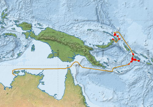
Voyage extents: 12° 18.1' S to 2° 34.4' S 129° 56.3' E to 158° 00.6' E Get voyage track shapefile Get CSV
Marlin Metadata:-
Metadata from OBIS Australia datasets:- biological data is published via the OBIS-AU IPT server and delivered to one or more of OBIS, ALA and GBIF
Download from OBIS Australia IPT View at - Ocean Biodiversity Information System (OBIS) Atlas of Living Australia (ALA) GBIF
Participants - on ship:-
| Name | Role | Organisation |
|---|---|---|
| A. Qopoto | Australian National University | |
| Brent McInnes | Chief Scientist | CSIRO Exploration and Mining |
| Cornel de Ronde | Institute of Geological and Nuclear Sciences, NZ | |
| Daniel Conwell | CSIRO Marine Research | |
| Des Patterson | CSIRO Exploration and Mining | |
| Edward T. Baker | National Oceanic and Atmospheric Administration | |
| Gary J. Massoth | Institute of Geological and Nuclear Sciences, NZ | |
| Pamela Brodie | CSIRO Marine Research | |
| Richard Arculus | Australian National University | |
| Ron Plaschke | Cruise Manager | CSIRO Marine Research |
This list includes those that may have only been on part of the voyage. See voyage reports on 'Reports and Maps' tab for details.
Marine National Facility Reports - plans, summaries and data processing
-
FR200004 Voyage Plan
- includes objectives, investigator details, proposed data collection, voyage track and equipment to be used.
-

Publications, reports and datasets from this voyage.
IPT Resource
- Seabird observations in Australian and adjacent seas from voyages of the RV Franklin, RV Southern Surveyor, Southern Supporter and RV Aurora Australis (1988-2012) (Darwin Core Archive) External link to reference
Journal Article
- Chadwick, John,Perfit, Michael,McInnes, Brent,Kamenov, George,Plank, Terry,Jonasson, Ian,Chadwick, Claire (2009) Arc lavas on both sides of a trench: Slab window effects at the Solomon Islands triple junction, SW Pacific. Earth and Planetary Science Letters 279 pp293-302. 10.1016/j.epsl.2009.01.001
- Cheshire, N. (2010) Procellariiformes observed around Papua New Guinea including the Bismarck Archipelago from 1985 to 2007. South Australian Ornithologist Vol 36, parts 1 &2 (p. 9-24)
- Liao, Renqiang,Zhu, Hongli,Li, Congying,Liu, He,Sun, Weidong (2023) Iron isotope heterogeneity in magmas of subduction zones and its origin. Lithos 458-459 pp107360-. 10.1016/j.lithos.2023.107360
Search for publications, reports and datasets from this and other voyages
Data publishing
This is a list of online datasets hosted by CSIRO. Other processed datasets hosted by collaborating organisations may be found on the 'Metadata' or "Reports, Publications and Maps' tab.
Use the Get data link on the right to extract data using the NCMI Data Trawler.
| Data Stream | Data Summary | Get data | ||||||||||||||
|---|---|---|---|---|---|---|---|---|---|---|---|---|---|---|---|---|
| ADCP Data |
|
Get Data from Trawler Download NetCDF dataset fr0004adcpCDF.zip Download dataset 7.2 Mb (1.7 Mb when compressed) Processing report for this dataset |
||||||||||||||
| Marine biodiversity observations and/or samples |
|
Get Data from Trawler |
||||||||||||||
| Underway |
|
Get Data from Trawler |
Deployments by start time:- Click on column header to sort. Use link on 'Deployment' to see full details. Use the CSV button at the bottom to export data (tab delimited).
Search for deployments from this voyage and others
| Deployment | Operation | Station | Cast | Gear | Project | Start and end times | Start Location | End Location | Depth range | Max Depth | Description | |||
|---|---|---|---|---|---|---|---|---|---|---|---|---|---|---|
| Underway System [details] | Anemometer,Barometer,Gyro-MK 10,Humidity probe,Licor-UWQ 4653,RIMCO vane driving potentiometer,Ships log,Simrad EA500 Echosounder,Temperature sensor-AD590J,ThermoSalinoGraph (TSG)-Franklin,ThermoSalinoGraph (TSG)-Franklin | 104 | 2000-05-04 00:00 | 2000-05-23 23:59 | -4.2023 | 152.1670 | -12.3007 | 130.6680 | ||||||
| ADCP Data [details] | RDI VM-150 Acoustic Doppler current profiler | 104 | 2000-05-05 00:00 | 2000-05-22 07:40 | -4.2760 | 152.2600 | -10.8170 | 134.9490 | 384.8 | |||||
| Sediment Sampling [details] | SHDR-03 | 104 | 2000-05-06 00:00 | -3.5212 | 153.2830 | |||||||||
| Sediment Sampling [details] | SHDR-02 | 104 | 2000-05-06 00:00 | -4.1343 | 153.5245 | |||||||||
| Sediment Sampling [details] | SHDR-01 | 104 | 2000-05-06 00:00 | -4.1820 | 153.6915 | |||||||||
| Sediment Sampling [details] | SHDR-04 | 104 | 2000-05-06 00:00 | -3.5272 | 153.2482 | |||||||||
| Sediment Sampling [details] | SHDR-05 | 104 | 2000-05-06 00:00 | -3.5363 | 153.2410 | |||||||||
| Sediment Sampling [details] | SHDR-06 | 104 | 2000-05-07 00:00 | -3.3172 | 152.5830 | |||||||||
| Sediment Sampling [details] | SHDR-07 | 104 | 2000-05-07 00:00 | -3.3143 | 152.5833 | |||||||||
| Sediment Sampling [details] | SHDR-08 | 104 | 2000-05-07 00:00 | -3.2557 | 152.5433 | |||||||||
| Sediment Sampling [details] | SHGR-01 | 104 | 2000-05-07 00:00 | -3.3157 | 152.5832 | |||||||||
| Sediment Sampling [details] | SHGR-02 | 104 | 2000-05-08 00:00 | -3.1072 | 152.6617 | |||||||||
| Sediment Sampling [details] | SHDR-09 | 104 | 2000-05-08 00:00 | -3.2557 | 152.5445 | |||||||||
| Sediment Sampling [details] | SHGR-03 | 104 | 2000-05-08 00:00 | -3.0915 | 152.7058 | |||||||||
| Sediment Sampling [details] | SHSC-04 | 104 | 2000-05-08 00:00 | -3.0918 | 152.7062 | |||||||||
| Sediment Sampling [details] | SHSC-03 | 104 | 2000-05-08 00:00 | -3.1062 | 152.6643 | |||||||||
| Sediment Sampling [details] | SHSC-02 | 104 | 2000-05-08 00:00 | -3.1663 | 152.6870 | |||||||||
| Sediment Sampling [details] | SHSC-01 | 104 | 2000-05-08 00:00 | -3.1043 | 152.7642 | |||||||||
| Sediment Sampling [details] | SHGR-04 | 104 | 2000-05-08 00:00 | -3.0698 | 152.6737 | |||||||||
| Sediment Sampling [details] | SHDR-10 | 104 | 2000-05-11 00:00 | -7.5145 | 156.6608 | |||||||||
| Sediment Sampling [details] | SHDR-11 | 104 | 2000-05-11 00:00 | -7.5130 | 156.6607 | |||||||||
| Sediment Sampling [details] | SHGR-06 | 104 | 2000-05-11 00:00 | -7.5867 | 156.7163 | |||||||||
| Sediment Sampling [details] | SHGR-05 | 104 | 2000-05-11 00:00 | -7.5142 | 156.6648 | |||||||||
| Sediment Sampling [details] | SHDR-14 | 104 | 2000-05-11 00:00 | -8.6782 | 156.6772 | |||||||||
| Sediment Sampling [details] | SHDR-13 | 104 | 2000-05-11 00:00 | -8.5420 | 156.5397 | |||||||||
| Sediment Sampling [details] | SHDR-12 | 104 | 2000-05-11 00:00 | -8.3677 | 156.5258 | |||||||||
| Sediment Sampling [details] | SHGR07R | 104 | 2000-05-11 00:00 | -8.3650 | 156.5217 | |||||||||
| Sediment Sampling [details] | SHDR-15 | 104 | 2000-05-12 00:00 | -8.7430 | 157.0122 | |||||||||
| Sediment Sampling [details] | SHDR-16 | 104 | 2000-05-12 00:00 | -8.7400 | 157.0083 | |||||||||
| Sediment Sampling [details] | SHDR-20 | 104 | 2000-05-12 00:00 | -8.7238 | 156.9720 | |||||||||
| Sediment Sampling [details] | SHDR-19 | 104 | 2000-05-12 00:00 | -8.7500 | 157.0290 | |||||||||
| Sediment Sampling [details] | SHDR-18 | 104 | 2000-05-12 00:00 | -8.7362 | 157.0088 | |||||||||
| Sediment Sampling [details] | SHDR-17 | 104 | 2000-05-12 00:00 | -8.7328 | 156.9910 | |||||||||
| Sediment Sampling [details] | SHDR-25 | 104 | 2000-05-13 00:00 | -8.8722 | 157.1408 | |||||||||
| Sediment Sampling [details] | SHDR-24 | 104 | 2000-05-13 00:00 | -8.7952 | 157.1717 | |||||||||
| Sediment Sampling [details] | SHDR-23 | 104 | 2000-05-13 00:00 | -8.6625 | 157.1572 | |||||||||
| Sediment Sampling [details] | SHDR-22 | 104 | 2000-05-13 00:00 | -8.8402 | 157.1892 | |||||||||
| Sediment Sampling [details] | SHDR-21 | 104 | 2000-05-13 00:00 | -8.8408 | 157.1585 | |||||||||
| Sediment Sampling [details] | SHGR-11 | 104 | 2000-05-14 00:00 | -8.9850 | 157.9800 | |||||||||
| Sediment Sampling [details] | SHGR-10 | 104 | 2000-05-14 00:00 | -9.0023 | 157.9595 | |||||||||
| Sediment Sampling [details] | SHGR-09 | 104 | 2000-05-14 00:00 | -9.0023 | 157.9568 | |||||||||
| Sediment Sampling [details] | SHGR-08 | 104 | 2000-05-14 00:00 | -9.0057 | 157.9802 | |||||||||
| Sediment Sampling [details] | SHGR-12 | 104 | 2000-05-14 00:00 | -8.9842 | 157.9637 | |||||||||
| Sediment Sampling [details] | SHDR-26 | 104 | 2000-05-14 00:00 | -9.0070 | 157.9168 | |||||||||
| Sediment Sampling [details] | SHDR-27 | 104 | 2000-05-15 00:00 | -8.7370 | 157.0013 | |||||||||
| Sediment Sampling [details] | SHDR-28 | 104 | 2000-05-15 00:00 | -8.7418 | 157.0055 | |||||||||
| Sediment Sampling [details] | SHSC-12 | 104 | 2000-05-15 00:00 | -9.0325 | 157.9302 | |||||||||
| Sediment Sampling [details] | SHDR-31 | 104 | 2000-05-15 00:00 | -8.5830 | 156.4978 | |||||||||
| Sediment Sampling [details] | SHDR-30 | 104 | 2000-05-15 00:00 | -8.6058 | 156.5457 | |||||||||
| Sediment Sampling [details] | SHDR-29 | 104 | 2000-05-15 00:00 | -8.8035 | 156.7928 | |||||||||
| Sediment Sampling [details] | SHDR-32 | 104 | 2000-05-16 00:00 | -8.6593 | 156.4810 | |||||||||
| Sediment Sampling [details] | SHDR-33 | 104 | 2000-05-16 00:00 | -8.6607 | 156.4810 | |||||||||
| Sediment Sampling [details] | SHDR-34 | 104 | 2000-05-16 00:00 | -8.9375 | 156.4925 | |||||||||
| Sediment Sampling [details] | SHGR-13 | 104 | 2000-05-16 00:00 | -9.2200 | 156.3172 | |||||||||
| Sediment Sampling [details] | SHGR-14 | 104 | 2000-05-16 00:00 | -9.1415 | 156.3867 | |||||||||
| Sediment Sampling [details] | SHDR-35 | 104 | 2000-05-17 00:00 | -9.7405 | 155.7717 | |||||||||
| Sediment Sampling [details] | SHGR-15 | 104 | 2000-05-17 00:00 | -9.1417 | 156.3330 | |||||||||
| Sediment Sampling [details] | SHGR-16 | 104 | 2000-05-17 00:00 | -9.2005 | 156.2327 | |||||||||