Voyage details and related metadata, reports, events and data.
FR 08/99
(alternative identifier: FR199908)
- is a Marine National Facility ![]() voyage
voyage
Period: 1999-11-24 00:00 to 1999-12-15 00:00 Local
Duration: 21.00 days
From: Darwin To: Cairns
Region: Gulf of Carpentaria
Ship: Franklin [details]
Description:
This information was taken from the Cruise Plan
Geophysical Experiment (Heinson/White)
The Carpentaria electrical conductivity anomaly is a major geological shear zone extending over a thousand kilometres in an approximately north-south orientation in northern Queensland. It has been mapped on land by various geomagnetic and magnetotelluric arrays, but the relationship between the conductivity anomaly and major tectonic boundaries is not straightforward. The offshore extent of the anomaly is unknown and poorly constrained by land measurements around the Gulf. The scientific objectives are therefore to:
1. Map the location of the Carpentaria anomaly and examine its spatial relationship with the tectonic structures in the region.
2. To determine the depth and length of the anomaly into the Gulf, and hence better understand the causes of high electrical conductance within the crust.
3. To relate the electrical properties to the tectonic evolution of northern Australia.
Oceanographic Experiment (Tomczak)
The purpose of the study is to develop a ship-borne rainfall measuring system based on the navigational radar. The method of measuring rain with the ship's radar was previously tried during the R/V Franklin voyage FR0796. It was shown that the radar can successfully monitor spatial rain distribution around the ship, which enables quantitative estimates of area-average precipitation using the thresholding technique. In the present proposal we attempt to substantially improve the accuracy of radar rainfall measurements by using advanced radar signal processing and thorough calibration and validation of rainfall measurements.
Instruments used include Sea floor magnetometers, Acoustic recall system, FURONO Navigational Radar, Thermosalinograph, Bouy mounted Rainguages, Thoroid Bouys, Acoustic deck unit, Towed SP instrument.
Leader: G. Heinson (Adelaide University)
Project: National Facility External Users: G. Heinson (Adelaide University) [details]
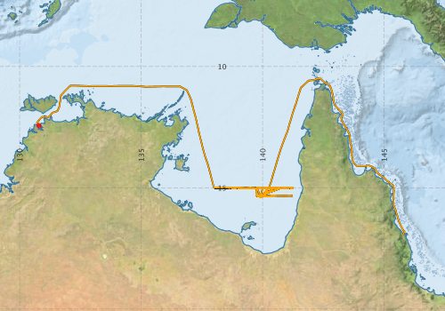
Voyage extents: 16° 56.2' S to 10° 28.0' S 130° 42.2' E to 145° 50.3' E Get voyage track shapefile Get CSV
Marlin Metadata:-
Metadata from OBIS Australia datasets:- biological data is published via the OBIS-AU IPT server and delivered to one or more of OBIS, ALA and GBIF
Download from OBIS Australia IPT View at - Ocean Biodiversity Information System (OBIS) Atlas of Living Australia (ALA) GBIF
Participants - on ship:-
| Name | Role | Organisation |
|---|---|---|
| Adrian Costar | Geophysics | Flinders University |
| Daniel Conwell | CSIRO Marine Research | |
| Graham Heinson | Chief Scientist | Flinders University |
| Ian Helmond | CSIRO Marine Research | |
| Igor Popkov | Geophysics | Flinders University |
| Ivan Lebedev | Flinders University | |
| Lindsay Pender | Cruise Manager | CSIRO Marine Research |
| Matthias Tomczak | Flinders University | |
| Wayne Peacock | Flinders University |
This list includes those that may have only been on part of the voyage. See voyage reports on 'Reports and Maps' tab for details.
Marine National Facility Reports - plans, summaries and data processing
-
FR199908 Voyage Plan
- includes objectives, investigator details, proposed data collection, voyage track and equipment to be used.
-
FR199908 Voyage Summary
- includes preliminary results, voyage narrative, types of data collected with C77/ROSCOP codes.
-

Publications, reports and datasets from this voyage.
IPT Resource
- Seabird observations in Australian and adjacent seas from voyages of the RV Franklin, RV Southern Surveyor, Southern Supporter and RV Aurora Australis (1988-2012) (Darwin Core Archive) External link to reference
Search for publications, reports and datasets from this and other voyages
Data publishing
This is a list of online datasets hosted by CSIRO. Other processed datasets hosted by collaborating organisations may be found on the 'Metadata' or "Reports, Publications and Maps' tab.
Use the Get data link on the right to extract data using the NCMI Data Trawler.
| Data Stream | Data Summary | Get data | ||||||||||||||
|---|---|---|---|---|---|---|---|---|---|---|---|---|---|---|---|---|
| ADCP Data |
|
Get Data from Trawler Download ASCII dataset - fr9908adcp.zip Download NetCDF dataset fr9908adcp.zip Processing report for this dataset |
||||||||||||||
| Marine biodiversity observations and/or samples |
|
Get Data from Trawler |
||||||||||||||
| Underway |
|
Get Data from Trawler |
Deployments by start time:- Click on column header to sort. Use link on 'Deployment' to see full details. Use the CSV button at the bottom to export data (tab delimited).
Search for deployments from this voyage and others
| Deployment | Operation | Station | Cast | Gear | Project | Start and end times | Start Location | End Location | Depth range | Max Depth | Description | |||
|---|---|---|---|---|---|---|---|---|---|---|---|---|---|---|
| Underway System [details] | Anemometer,Anemometer,Anemometer,Barometer,Gyro-MK 10,Humidity probe,Licor-UWQ 4653,RIMCO vane driving potentiometer,RIMCO vane driving potentiometer,Ships log,Simrad EA500 Echosounder,Temperature sensor-AD590J,ThermoSalinoGraph (TSG)-Franklin,ThermoSalinoGraph (TSG)-Franklin | 111 | 1999-11-24 00:00 | 1999-12-14 23:59 | -12.4255 | 130.7830 | -16.9365 | 145.7810 | ||||||
| ADCP Data [details] | RDI VM-150 Acoustic Doppler current profiler | 111 | 1999-11-24 00:40 | 1999-12-14 19:40 | -12.4560 | 130.8090 | -16.7680 | 145.8180 | 64.8 | |||||