Voyage details and related metadata, reports, events and data.
FR 02/98
(alternative identifier: FR199802)
- is a Marine National Facility ![]() voyage
voyage
Period: 1998-01-30 00:00 to 1998-02-17 00:00 Local
Duration: 18.00 days
From: Adelaide To: Hobart
Region: Southern Ocean and Tasman Sea
Ship: Franklin [details]
Description: Cruise FR 02/98 was undertaken for Subtropical Front temperature and transport studies (cruise 1 of 2). The aims of this first cruise of two (FR 10/98), being in the summer season is to: verify or refute the permanent existence and regional continuity of the Subtropical Front south of Australia; determine the seasonal variation in position and magnitude of the sea surface temperature gradient across the Subtropical Front south of Australia and in the Tasman Sea; estimate the velocity field and associated transport of the Subtropical Front; and determine the continuity of transport from the east Indian Ocean to the Tasman Sea. Survey methods included thermosalingraph and ADCP transect from Gulf St. Vincent to 40 degrees S, 118 degrees E, SeaSoar transects across the Subtropical Front, each on average 300 km long, CTDs and underway instrumentation. Recovery of two shallow current meter moorings from the shelf off western Tasmania was also conducted.
Leader: M. Tomczak (Flinders University)
Project: National Facility External Users: M. Tomczak (Flinders University) [details]
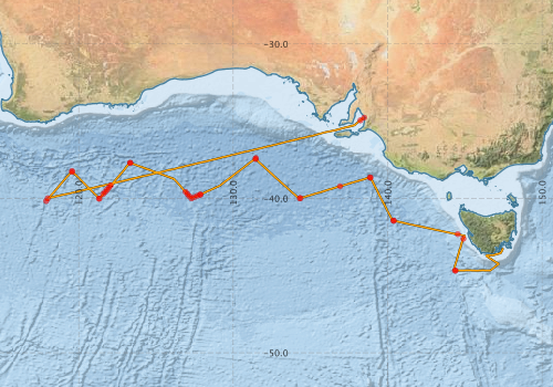
Voyage extents: 44° 41.6' S to 34° 46.5' S 117° 51.9' E to 147° 27.2' E Get voyage track shapefile Get CSV
Marlin Metadata:-
Participants - on ship:-
| Name | Role | Organisation |
|---|---|---|
| Charles James | FIAMS | |
| Dave Terhell | CSIRO ORV | |
| Duncan Tippins | FIAMS | |
| Ian Helmond | CSIRO ORV | |
| Lindsay Pender | Cruise Manager | CSIRO ORV |
| Matthias Tomczak | Chief Scientist | FIAMS |
| Maurico Mata | FIAMS | |
| Phil Adams | CSIRO ORV |
This list includes those that may have only been on part of the voyage. See voyage reports on 'Reports and Maps' tab for details.
Marine National Facility Reports - plans, summaries and data processing
-
FR199802 Voyage Summary
- includes preliminary results, voyage narrative, types of data collected with C77/ROSCOP codes.
-

Search for publications, reports and datasets from this and other voyages
Data publishing
This is a list of online datasets hosted by CSIRO. Other processed datasets hosted by collaborating organisations may be found on the 'Metadata' or "Reports, Publications and Maps' tab.
Use the Get data link on the right to extract data using the NCMI Data Trawler.
| Data Stream | Data Summary | Get data | ||||||||||||||
|---|---|---|---|---|---|---|---|---|---|---|---|---|---|---|---|---|
| ADCP Data |
|
Get Data from Trawler Download ASCII dataset - fr9802adcp.zip Download NetCDF dataset fr9802adcp.zip Processing report for this dataset |
||||||||||||||
| CTD profile |
|
Get Data from Trawler |
||||||||||||||
| Hydrology |
|
Get Data from Trawler Processing report for this dataset |
||||||||||||||
| Towed CTD |
|
Get Data from Trawler Download FR199802 Seasoar data |
||||||||||||||
| Underway |
|
Get Data from Trawler |
Deployments by start time:- Click on column header to sort. Use link on 'Deployment' to see full details. Use the CSV button at the bottom to export data (tab delimited).
Search for deployments from this voyage and others
| Deployment | Operation | Station | Cast | Gear | Project | Start and end times | Start Location | End Location | Depth range | Max Depth | Description | |||
|---|---|---|---|---|---|---|---|---|---|---|---|---|---|---|
| Underway System [details] | Anemometer,Anemometer,Anemometer,Barometer,Gyro-MK 10,Humidity probe,Licor-UWQ 4653,RIMCO vane driving potentiometer,RIMCO vane driving potentiometer,Ships log,Simrad EA500 Echosounder,Temperature sensor-AD590J,ThermoSalinoGraph (TSG),ThermoSalinoGraph (TSG) | 124 | 1998-01-30 02:35 | 1998-02-17 02:05 | -34.7752 | 138.4840 | -43.2223 | 147.4500 | ||||||
| ADCP Data [details] | RDI VM-150 Acoustic Doppler current profiler | 124 | 1998-01-30 04:00 | 1998-02-17 01:40 | -34.9420 | 138.2400 | -43.2830 | 147.4480 | 408.8 | |||||
| CTD Cast / Hydrology [details] | 1 | Cast 1 | 124 | 1998-02-03 20:09 | 1998-02-03 23:32 | -40.0003 | 118.0037 | -40.0210 | 117.9997 | 0 | ||||
| Towed CTD [details] | SeaSoar | 124 | 1998-02-04 06:28 | 1998-02-04 14:03 | -40.1660 | 117.8925 | -39.2942 | 118.6550 | 220 | Leg: 1 | ||||
| CTD Cast / Hydrology [details] | 1 | Cast 2 | 124 | 1998-02-05 00:16 | 1998-02-05 01:29 | -38.2242 | 119.5713 | -38.2383 | 119.5778 | 0 | ||||
| Towed CTD [details] | SeaSoar | 124 | 1998-02-05 03:25 | 1998-02-05 10:15 | -38.2865 | 119.5738 | -38.9503 | 120.2752 | 204 | Leg: 2 | ||||
| CTD Cast / Hydrology [details] | 1 | Cast 3 | 124 | 1998-02-05 22:43 | 1998-02-05 23:58 | -40.0177 | 121.3085 | -40.0312 | 121.3293 | 0 | ||||
| Towed CTD [details] | SeaSoar | 124 | 1998-02-06 00:19 | 1998-02-07 03:58 | -40.0115 | 121.3490 | -38.5215 | 122.6272 | 202 | Leg: 3 | ||||
| CTD Cast / Hydrology [details] | 1 | Cast 4 | 124 | 1998-02-06 04:04 | 1998-02-06 04:14 | -39.7222 | 121.5820 | -39.7237 | 121.5827 | 0 | ||||
| CTD Cast / Hydrology [details] | 1 | Cast 5 | 124 | 1998-02-06 05:23 | 1998-02-06 05:34 | -39.5850 | 121.7067 | -39.5855 | 121.7055 | 0 | ||||
| CTD Cast / Hydrology [details] | 1 | Cast 6 | 124 | 1998-02-06 06:48 | 1998-02-06 07:01 | -39.4450 | 121.8345 | -39.4443 | 121.8322 | 0 | ||||
| CTD Cast / Hydrology [details] | 1 | Cast 7 | 124 | 1998-02-06 08:18 | 1998-02-06 08:29 | -39.3035 | 121.9542 | -39.3032 | 121.9523 | 0 | ||||
| CTD Cast / Hydrology [details] | 1 | Cast 8 | 124 | 1998-02-06 09:43 | 1998-02-06 09:54 | -39.1673 | 122.0743 | -39.1678 | 122.0745 | 0 | ||||
| CTD Cast / Hydrology [details] | 1 | Cast 9 | 124 | 1998-02-07 11:33 | 1998-02-07 12:46 | -37.6937 | 123.3280 | -37.6910 | 123.3262 | 0 | ||||
| Towed CTD [details] | SeaSoar | 124 | 1998-02-07 13:20 | 1998-02-07 19:59 | -37.7038 | 123.3402 | -38.0723 | 124.3530 | 198 | Leg: 4 | ||||
| CTD Cast / Hydrology [details] | 1 | Cast 10 | 124 | 1998-02-08 20:03 | 1998-02-08 20:14 | -39.5808 | 126.9157 | -39.5803 | 126.9138 | 0 | ||||
| CTD Cast / Hydrology [details] | 1 | Cast 11 | 124 | 1998-02-08 21:25 | 1998-02-08 21:37 | -39.7218 | 127.0452 | -39.7213 | 127.0428 | 0 | ||||
| CTD Cast / Hydrology [details] | 1 | Cast 12 | 124 | 1998-02-08 22:42 | 1998-02-08 23:53 | -39.8623 | 127.1690 | -39.8702 | 127.1763 | 0 | ||||
| CTD Cast / Hydrology [details] | 1 | Cast 13 | 124 | 1998-02-09 00:51 | 1998-02-09 01:03 | -39.9995 | 127.2998 | -40.0017 | 127.3033 | 0 | ||||
| CTD Cast / Hydrology [details] | 1 | Cast 14 | 124 | 1998-02-09 02:12 | 1998-02-09 02:23 | -39.9232 | 127.4858 | -39.9257 | 127.4873 | 0 | ||||
| CTD Cast / Hydrology [details] | 1 | Cast 15 | 124 | 1998-02-09 03:29 | 1998-02-09 03:40 | -39.8383 | 127.6765 | -39.8400 | 127.6755 | 0 | ||||
| CTD Cast / Hydrology [details] | 1 | Cast 16 | 124 | 1998-02-09 04:42 | 1998-02-09 04:53 | -39.7540 | 127.8635 | -39.7562 | 127.8648 | 0 | ||||
| Towed CTD [details] | SeaSoar | 124 | 1998-02-09 05:17 | 1998-02-09 11:50 | -39.7530 | 127.8880 | -39.3205 | 128.8253 | 196 | Leg: 5 | ||||
| CTD Cast / Hydrology [details] | 1 | Cast 17 | 124 | 1998-02-10 09:58 | 1998-02-10 11:07 | -37.3952 | 131.4693 | -37.4012 | 131.4647 | 0 | ||||
| Towed CTD [details] | SeaSoar | 124 | 1998-02-10 11:46 | 1998-02-10 18:18 | -37.4475 | 131.4445 | -38.1050 | 132.1613 | 198 | Leg: 6 | ||||
| CTD Cast / Hydrology [details] | 1 | Cast 18 | 124 | 1998-02-11 13:18 | 1998-02-11 14:28 | -39.9957 | 134.3058 | -39.9948 | 134.3033 | 0 | ||||
| Towed CTD [details] | SeaSoar | 124 | 1998-02-11 15:01 | 1998-02-11 21:40 | -39.9902 | 134.3558 | -39.6630 | 135.4298 | 198 | Leg: 7 | ||||
| CTD Cast / Hydrology [details] | 1 | Cast 19 | 124 | 1998-02-12 06:46 | 1998-02-12 06:58 | -39.2158 | 136.9235 | -39.2170 | 136.9250 | 0 | ||||
| CTD Cast / Hydrology [details] | 1 | Cast 20 | 124 | 1998-02-12 19:23 | 1998-02-12 20:34 | -38.6452 | 138.8568 | -38.6458 | 138.8648 | 0 | ||||
| Towed CTD [details] | SeaSoar | 124 | 1998-02-12 20:53 | 1998-02-13 03:33 | -38.6518 | 138.8887 | -39.4690 | 139.3087 | 198 | Leg: 8 | ||||
| CTD Cast / Hydrology [details] | 1 | Cast 21 | 124 | 1998-02-13 20:19 | 1998-02-13 21:36 | -41.4375 | 140.3725 | -41.4453 | 140.3823 | 0 | ||||
| Towed CTD [details] | SeaSoar | 124 | 1998-02-13 21:46 | 1998-02-14 04:31 | -41.4500 | 140.4073 | -41.7093 | 141.5820 | 202 | Leg: 9 | ||||
| CTD Cast / Hydrology [details] | 1 | Cast 22 | 124 | 1998-02-14 21:34 | 1998-02-14 22:44 | -42.3135 | 144.5440 | -42.3103 | 144.5503 | 0 | ||||
| Towed CTD [details] | SeaSoar | 124 | 1998-02-15 04:29 | 1998-02-15 11:17 | -42.6097 | 144.9073 | -43.5045 | 144.6130 | 202 | Leg: 10 | ||||
| CTD Cast / Hydrology [details] | 1 | Cast 23 | 124 | 1998-02-15 21:11 | 1998-02-15 22:21 | -44.6735 | 144.3618 | -44.6783 | 144.3618 | 0 | ||||
| Towed CTD [details] | SeaSoar | 124 | 1998-02-15 22:41 | 1998-02-16 05:24 | -44.6798 | 144.3970 | -44.6740 | 145.6740 | 202 | Leg: 11 | ||||