Voyage details and related metadata, reports, events and data.
FR 05/97
(alternative identifier: FR199705)
- is a Marine National Facility ![]() voyage
voyage
Period: 1997-05-24 00:00 to 1997-06-11 00:00 Local
Duration: 18.00 days
From: Madang To: Townsville
Region: Papua New Guinea coast
Ship: Franklin [details]
Description: Cruise FR 05/97 (cruise 2 in a series of 4 for TROPICS97 - Tropical River-Ocean Processes in Coastal Settings) was undertaken to collect sediment samples and to survey the continental shelf, slope and rise between Manam Island and Wewak on the north coast of PNG in the Bismarck Sea and the Gulf of Papua. Survey methods included cores, grabs, seismic lines, sidescan sonar fish tows, CTD, and underway instrumentation. Data, water and sediment samples were collected for on board and laboratory analyses. Sub-samples from grabs were collected for radio chemistry, bulk chemistry and grain size analysis. Two sediment trap arrays were also deployed and one recovered (previously deployed on cruise FR 04/97). Related cruises are FR 04/97, FR 06/97 and FR 07/97.
Leader: K. Woolfe (James Cook University)
Project: National Facility External Users: K. Woolfe (James Cook University) [details]
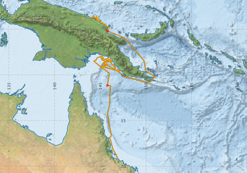
Voyage extents: 19° 10.4' S to 3° 31.7' S 144° 03.1' E to 150° 58.5' E Get voyage track shapefile Get CSV
Marlin Metadata:-
Participants - on ship:-
| Name | Role | Organisation |
|---|---|---|
| Andy Revill | CSIRO Marine Research | |
| Bob Beattie | CSIRO ORV | |
| Charles Nittrouer | State University of New York | |
| David Mucciarone | Rice University | |
| David Smith | University of Melbourne | |
| Erik Madsen | CSIRO ORV | |
| Greg Brunskill | Australian Institute of Marine Science (AIMS) | |
| Irena Zagorskis | Australian Institute of Marine Science (AIMS) | |
| JP Walsh | State University of New York | |
| John Milliman | Virginia Institute of Marine Science | |
| John Soles | Australian Institute of Marine Science (AIMS) | |
| Katie Farnsworth | Virginia Institute of Marine Science | |
| Ken Woolfe | James Cook University | |
| Kevin Hooper | James Cook University | |
| Megan Bolin | Virginia Institute of Marine Science | |
| Richard Purdon | James Cook University | |
| Tim Dellapenna | College of William and Mary |
This list includes those that may have only been on part of the voyage. See voyage reports on 'Reports and Maps' tab for details.
Marine National Facility Reports - plans, summaries and data processing
-
FR199705 Voyage Summary
- includes preliminary results, voyage narrative, types of data collected with C77/ROSCOP codes.
-
FR199705 Voyage Plan
- includes objectives, investigator details, proposed data collection, voyage track and equipment to be used.
-

Search for publications, reports and datasets from this and other voyages
Data publishing
This is a list of online datasets hosted by CSIRO. Other processed datasets hosted by collaborating organisations may be found on the 'Metadata' or "Reports, Publications and Maps' tab.
Use the Get data link on the right to extract data using the NCMI Data Trawler.
| Data Stream | Data Summary | Get data | ||||||||||||
|---|---|---|---|---|---|---|---|---|---|---|---|---|---|---|
| Underway |
|
Get Data from Trawler |
Deployments by start time:- Click on column header to sort. Use link on 'Deployment' to see full details. Use the CSV button at the bottom to export data (tab delimited).
Search for deployments from this voyage and others
| Deployment | Operation | Station | Cast | Gear | Project | Start and end times | Start Location | End Location | Depth range | Max Depth | Description | |||
|---|---|---|---|---|---|---|---|---|---|---|---|---|---|---|
| Underway System [details] | Anemometer,Anemometer,Anemometer,Barometer,Gyro-MK 10,Humidity probe,Licor-UWQ 4653,RIMCO vane driving potentiometer,RIMCO vane driving potentiometer,Ships log,Simrad EA500 Echosounder,Temperature sensor-AD590J,ThermoSalinoGraph (TSG),ThermoSalinoGraph (TSG) | 121 | 1997-05-24 00:00 | 1997-06-10 22:00 | -5.2187 | 145.8300 | -19.1735 | 146.8780 | ||||||
| CTD Cast [details] | 1 | Cast 1 | 121 | 1997-06-08 07:54 | 1997-06-08 08:18 | -11.1545 | 145.7837 | -11.1568 | 145.7867 | 0 | ||||