Voyage details and related metadata, reports, events and data.
FR 09/96
(alternative identifier: FR199609)
- is a Marine National Facility ![]() voyage
voyage
Period: 1996-10-30 00:00 to 1996-11-22 00:00 Local
Duration: 23.00 days
From: Fremantle To: Darwin
Region: Exmouth Gulf/WA north coast waters
Ship: Franklin [details]
Description:
Cruise FR 09/96 was undertaken to study hydrocarbons in the region of Exmouth Gulf, shelf, slope and Exmouth Plateau. Survey methods included grab and core sampling, sediment trap and current meter arrays, SeaStar rigs, primary production profiles, large volume water sampling, ADCP, CTDs and underway instrumentation. Surface sediment sampling for microbiological experiments were also conducted. Data, sediment and water samples were collected for on board and laboratory analyses.
Moorings previously deployed in June 96 from AIMS ships were retrieved, serviced and redeployed successfully with the exception of the Scott Reef mooring.
Leader: G. Brunskill (AIMS) including other PIs
Project: National Facility External Users: G. Brunskill (AIMS) [details]
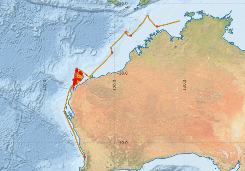
Voyage extents: 32° 03.3' S to 11° 44.4' S 112° 45.6' E to 129° 23.6' E Get voyage track shapefile Get CSV
Marlin Metadata:-
Metadata from OBIS Australia datasets:- biological data is published via the OBIS-AU IPT server and delivered to one or more of OBIS, ALA and GBIF
Download from OBIS Australia IPT View at - Ocean Biodiversity Information System (OBIS) Atlas of Living Australia (ALA) GBIF
Participants - on ship:-
| Name | Role | Organisation |
|---|---|---|
| Bradley Opdyke | Australian National University | |
| Cary McLean | Australian Institute of Marine Science (AIMS) | |
| Dave Vaudrey | Cruise Manager | CSIRO Division of Oceanography |
| Gregg Brunskill | Chief Investigator | Australian Institute of Marine Science (AIMS) |
| Irena Zagorskis | Australian Institute of Marine Science (AIMS) | |
| Jo Johnston | Australian Institute of Marine Science (AIMS) | |
| Jo-Anne Cavanagh | Australian Institute of Marine Science (AIMS) | |
| John Soles | Australian Institute of Marine Science (AIMS) | |
| Phil Adams | CSIRO Division of Oceanography | |
| Ron Plaschke | CSIRO Division of Oceanography | |
| Russel Hill | Australian Institute of Marine Science (AIMS) | |
| Sue Codi | Australian Institute of Marine Science (AIMS) | |
| Tenshi Ayukai | Australian Institute of Marine Science (AIMS) |
This list includes those that may have only been on part of the voyage. See voyage reports on 'Reports and Maps' tab for details.
Marine National Facility Reports - plans, summaries and data processing
-
FR199609 Voyage Summary
- includes preliminary results, voyage narrative, types of data collected with C77/ROSCOP codes.
-
FR199609 Voyage Plan
- includes objectives, investigator details, proposed data collection, voyage track and equipment to be used.
-

Publications, reports and datasets from this voyage.
IPT Resource
- Seabird observations in Australian and adjacent seas from voyages of the RV Franklin, RV Southern Surveyor, Southern Supporter and RV Aurora Australis (1988-2012) (Darwin Core Archive) External link to reference
Search for publications, reports and datasets from this and other voyages
Data publishing
This is a list of online datasets hosted by CSIRO. Other processed datasets hosted by collaborating organisations may be found on the 'Metadata' or "Reports, Publications and Maps' tab.
Use the Get data link on the right to extract data using the NCMI Data Trawler.
| Data Stream | Data Summary | Get data | ||||||||||||||
|---|---|---|---|---|---|---|---|---|---|---|---|---|---|---|---|---|
| ADCP Data |
|
Get Data from Trawler Download ASCII dataset - fr9609adcp.zip Download NetCDF dataset fr9609adcp.zip Processing report for this dataset |
||||||||||||||
| Marine biodiversity observations and/or samples |
|
Get Data from Trawler |
||||||||||||||
| CTD profile |
|
Get Data from Trawler Processing report for this dataset |
||||||||||||||
| Hydrology |
|
Get Data from Trawler Processing report for this dataset |
||||||||||||||
| Underway |
|
Get Data from Trawler |
Deployments by start time:- Click on column header to sort. Use link on 'Deployment' to see full details. Use the CSV button at the bottom to export data (tab delimited).
Search for deployments from this voyage and others
| Deployment | Operation | Station | Cast | Gear | Project | Start and end times | Start Location | End Location | Depth range | Max Depth | Description | |||
|---|---|---|---|---|---|---|---|---|---|---|---|---|---|---|
| Underway System [details] | Anemometer,Anemometer,Anemometer,Barometer,Gyro-MK 10,Humidity probe,Licor-UWQ 4653,RIMCO vane driving potentiometer,RIMCO vane driving potentiometer,Ships log,Simrad EA500 Echosounder,Temperature sensor-AD590J,ThermoSalinoGraph (TSG),ThermoSalinoGraph (TSG) | 113 | 1996-10-30 05:30 | 1996-11-21 22:00 | -32.0518 | 115.7430 | -12.4943 | 129.3930 | ||||||
| CTD Cast / Hydrology [details] | 1 | Cast 1 | 113 | 1996-11-02 01:44 | 1996-11-02 01:55 | -22.1142 | 114.1505 | 0 | ||||||
| CTD Cast / Hydrology [details] | 1 | Cast 2 | 113 | 1996-11-02 06:27 | 1996-11-02 06:38 | -21.6640 | 114.2387 | -21.6612 | 114.2440 | 0 | ||||
| CTD Cast / Hydrology [details] | 1 | Cast 3 | 113 | 1996-11-02 07:40 | 1996-11-02 07:57 | -21.5167 | 114.2667 | -21.5152 | 114.2738 | 0 | ||||
| CTD Cast / Hydrology [details] | 1 | Cast 4 | 113 | 1996-11-02 09:44 | 1996-11-02 10:05 | -21.2313 | 114.3097 | -21.2342 | 114.3100 | 0 | ||||
| CTD Cast / Hydrology [details] | 1 | Cast 5 | 113 | 1996-11-02 11:59 | 1996-11-02 12:27 | -20.9355 | 114.3575 | -20.9375 | 114.3613 | 0 | ||||
| CTD Cast / Hydrology [details] | 1 | Cast 6 | 113 | 1996-11-02 14:20 | 1996-11-02 14:44 | -20.6353 | 114.4023 | -20.6342 | 114.4033 | 0 | ||||
| CTD Cast / Hydrology [details] | 1 | Cast 7 | 113 | 1996-11-02 16:40 | 1996-11-02 17:03 | -20.3388 | 114.4487 | -20.3415 | 114.4480 | 0 | ||||
| CTD Cast / Hydrology [details] | 1 | Cast 8 | 113 | 1996-11-02 19:09 | 1996-11-02 19:34 | -20.0372 | 114.4913 | -20.0425 | 114.4913 | 0 | ||||
| CTD Cast / Hydrology [details] | 1 | Cast 9 | 113 | 1996-11-02 21:35 | 1996-11-02 22:03 | -19.7488 | 114.5383 | -19.7543 | 114.5443 | 0 | ||||
| ADCP Data [details] | RDI VM-150 Acoustic Doppler current profiler | 113 | 1996-11-03 04:20 | 1996-11-21 12:20 | -19.5860 | 114.6040 | -12.5110 | 129.3300 | 408.8 | |||||
| CTD Cast / Hydrology [details] | 1 | Cast 10 | 113 | 1996-11-03 04:28 | 1996-11-03 05:38 | -19.5857 | 114.6033 | -19.5903 | 114.6127 | 0 | ||||
| CTD Cast [details] | 1 | Cast 11 | 113 | 1996-11-04 02:16 | 1996-11-04 02:33 | -19.6905 | 114.5937 | -19.6897 | 114.5958 | 0 | ||||
| CTD Cast [details] | 1 | Cast 12 | 113 | 1996-11-04 08:41 | 1996-11-04 08:45 | -19.7280 | 114.6013 | -19.7283 | 114.6023 | 0 | ||||
| CTD Cast / Hydrology [details] | 1 | Cast 13 | 113 | 1996-11-05 03:20 | 1996-11-05 03:49 | -21.0225 | 114.3328 | -21.0202 | 114.3412 | 0 | ||||
| CTD Cast / Hydrology [details] | 1 | Cast 14 | 113 | 1996-11-06 02:04 | 1996-11-06 02:28 | -21.1043 | 114.4453 | -21.1042 | 114.4490 | 0 | ||||
| CTD Cast / Hydrology [details] | 1 | Cast 15 | 113 | 1996-11-07 04:54 | 1996-11-07 05:11 | -21.5947 | 114.2118 | -21.5885 | 114.2127 | 0 | ||||
| CTD Cast / Hydrology [details] | 1 | Cast 16 | 113 | 1996-11-07 12:55 | 1996-11-07 13:11 | -21.3847 | 114.4973 | -21.3850 | 114.5022 | 0 | ||||
| CTD Cast / Hydrology [details] | 1 | Cast 17 | 113 | 1996-11-07 20:50 | 1996-11-07 20:58 | -21.5020 | 114.5042 | -21.5030 | 114.5080 | 0 | ||||
| CTD Cast / Hydrology [details] | 1 | Cast 18 | 113 | 1996-11-08 02:20 | 1996-11-08 02:52 | -20.9897 | 114.1122 | -20.9888 | 114.1098 | 0 | ||||
| CTD Cast [details] | 1 | Cast 19 | 113 | 1996-11-08 04:54 | 1996-11-08 05:08 | -21.0162 | 114.3450 | -21.0115 | 114.3413 | 0 | ||||
| CTD Cast [details] | 1 | Cast 20 | 113 | 1996-11-08 06:44 | 1996-11-08 06:57 | -21.1067 | 114.4152 | -21.1032 | 114.4118 | 0 | ||||
| CTD Cast / Hydrology [details] | 1 | Cast 21 | 113 | 1996-11-09 01:30 | 1996-11-09 01:36 | -21.0155 | 115.1457 | -21.0153 | 115.1447 | 0 | ||||
| CTD Cast / Hydrology [details] | 1 | Cast 22 | 113 | 1996-11-09 02:39 | 1996-11-09 02:46 | -20.9687 | 115.0343 | -20.9673 | 115.0345 | 0 | ||||
| CTD Cast / Hydrology [details] | 1 | Cast 23 | 113 | 1996-11-09 04:06 | 1996-11-09 04:15 | -20.9180 | 114.9002 | -20.9182 | 114.9017 | 0 | ||||
| CTD Cast / Hydrology [details] | 1 | Cast 24 | 113 | 1996-11-09 05:31 | 1996-11-09 05:43 | -20.8677 | 114.7662 | -20.8672 | 114.7657 | 0 | ||||
| CTD Cast / Hydrology [details] | 1 | Cast 25 | 113 | 1996-11-09 07:22 | 1996-11-09 07:44 | -20.8165 | 114.6325 | -20.8183 | 114.6307 | 0 | ||||
| CTD Cast / Hydrology [details] | 1 | Cast 26 | 113 | 1996-11-10 01:54 | 1996-11-10 02:00 | -20.1817 | 115.3217 | -20.1800 | 115.3228 | 0 | ||||
| CTD Cast / Hydrology [details] | 1 | Cast 27 | 113 | 1996-11-10 03:00 | 1996-11-10 03:08 | -20.1155 | 115.2508 | -20.1140 | 115.2512 | 0 | ||||
| CTD Cast / Hydrology [details] | 1 | Cast 28 | 113 | 1996-11-10 04:15 | 1996-11-10 04:27 | -20.0508 | 115.1835 | -20.0507 | 115.1857 | 0 | ||||
| CTD Cast / Hydrology [details] | 1 | Cast 29 | 113 | 1996-11-10 05:30 | 1996-11-10 05:50 | -19.9835 | 115.1157 | -19.9847 | 115.1163 | 0 | ||||
| CTD Cast / Hydrology [details] | 1 | Cast 30 | 113 | 1996-11-10 07:13 | 1996-11-10 08:06 | -19.9170 | 115.0485 | -19.9138 | 115.0500 | 0 | ||||
| CTD Cast [details] | 1 | Cast 31 | 113 | 1996-11-10 12:10 | 1996-11-10 12:38 | -20.1340 | 115.0523 | -20.1292 | 115.0563 | 0 | ||||
| CTD Cast [details] | 1 | Cast 32 | 113 | 1996-11-11 02:24 | 1996-11-11 02:40 | -19.9247 | 115.0443 | -19.9240 | 115.0398 | 0 | ||||
| CTD Cast [details] | 1 | Cast 33 | 113 | 1996-11-11 04:29 | 1996-11-11 04:45 | -19.9368 | 115.0297 | -19.9388 | 115.0242 | 0 | ||||
| CTD Cast [details] | 1 | Cast 34 | 113 | 1996-11-11 06:16 | 1996-11-11 06:29 | -19.9507 | 115.0208 | -19.9535 | 115.0167 | 0 | ||||
| CTD Cast / Hydrology [details] | 1 | Cast 35 | 113 | 1996-11-12 01:36 | 1996-11-12 01:57 | -21.2815 | 114.3513 | -21.2755 | 114.3537 | 0 | ||||
| CTD Cast / Hydrology [details] | 1 | Cast 36 | 113 | 1996-11-12 03:24 | 1996-11-12 03:40 | -21.4347 | 114.2847 | -21.4310 | 114.2843 | 0 | ||||
| CTD Cast / Hydrology [details] | 1 | Cast 37 | 113 | 1996-11-12 05:58 | 1996-11-12 06:10 | -21.6990 | 114.1995 | -21.6952 | 114.2002 | 0 | ||||
| CTD Cast [details] | 1 | Cast 38 | 113 | 1996-11-15 04:20 | 1996-11-15 04:36 | -19.4082 | 114.6115 | -19.4042 | 114.6113 | 0 | ||||
| CTD Cast [details] | 1 | Cast 39 | 113 | 1996-11-17 01:26 | 1996-11-17 01:34 | -17.0332 | 119.6530 | -17.0318 | 119.6533 | 0 | ||||
| CTD Cast / Hydrology [details] | 1 | Cast 40 | 113 | 1996-11-18 03:58 | 1996-11-18 04:19 | -14.0895 | 121.7058 | -14.0877 | 121.7073 | 0 | ||||
| CTD Cast / Hydrology [details] | 1 | Cast 41 | 113 | 1996-11-19 00:44 | 1996-11-19 01:00 | -14.6447 | 122.3313 | -14.6448 | 122.3303 | 0 | ||||
| CTD Cast / Hydrology [details] | 1 | Cast 42 | 113 | 1996-11-20 18:26 | 1996-11-20 18:40 | -13.3092 | 126.1198 | -13.3090 | 126.1162 | 0 | ||||